This item has been sold, but you can get on the Waitlist to be notified if another example becomes available, or purchase a digital scan.
1690 Visscher Map of Ireland
HiberniaeRegnum-visscher-1690$437.50

Title
Hiberniae Regnum tam in praecipuas Ultoniae, Connaciae, Lageniae, et Momoniae, quam in minores earundem Provincias, et Ditiones subjacentes peraccurate divisum.
1690 (undated) 23 x 19.5 in (58.42 x 49.53 cm) 1 : 900000
1690 (undated) 23 x 19.5 in (58.42 x 49.53 cm) 1 : 900000
Description
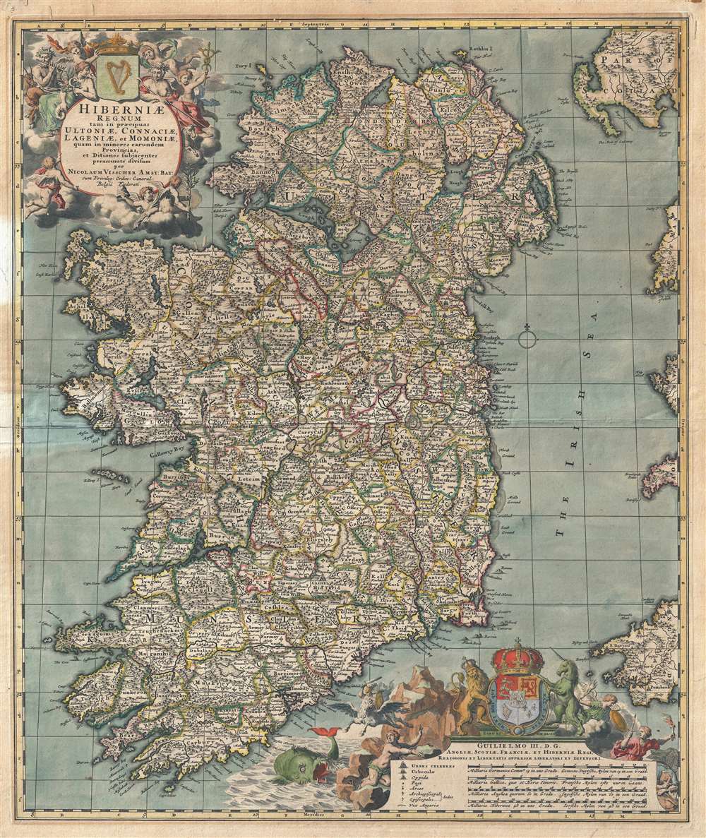
A beautiful example of Nicolas Visscher's c. 1690 map of Ireland in original old color. The map covers the entirety of Ireland and is subdivided into counties. Two impressive cartouches are rife with allegorical imagery, one appearing in the upper left, and a second in the lower right, surrounding the map's dedication, key, and scales. The map is dedicated to William III (1650 - 1702), also known as William of Orange, who became King of England Ireland and Scotland in 1689.
The elaborate title cartouche in the upper right is rich with Gaelic iconography, including the Gaelic Harp and allegorical representations of Pan, a Celtic adaptation of the Roman god Bacchus, and Brigit, the Celtic goddess of poetry, healing, and agriculture. The lower cartouche features the royal crest of England, Scotland and Ireland. It also includes an impressive sea monster.
The cartography follows on Frederick de Wit's map of 1662. Although several updates were implemented over the years, first by de Wit then by Visscher, most of the major changes were limited to the cartouche work. The map was later copied with minor revisions and changes by Petrus Schenk, Gerard Valk, and Johann Baptiste Homann.
Cartographer
Claes Jansz Visscher (1587 - 1652) established the Visscher family publishing firm, which were prominent Dutch map publishers for nearly a century. The Visscher cartographic story beings with Claes Jansz Visscher who established the firm in Amsterdam near the offices of Pieter van den Keer and Jadocus Hondius. Many hypothesize that Visscher may have been one of Hondius's pupils and, under examination, this seems logical. The first Visscher maps appear around 1620 and include numerous individual maps as well as an atlas compiled of maps by various cartographers including Visscher himself. Upon the death of Claes, the firm fell into the hands of his son Nicholas Visscher I (1618 - 1679), who in 1677 received a privilege to publish from the States of Holland and West Friesland. The firm would in turn be passed on to his son, Nicholas Visscher II (1649 - 1702). Visscher II applied for his own privilege, receiving it in 1682. Most of the maps bearing the Visscher imprint were produced by these two men. Many Visscher maps also bear the imprint Piscator (a Latinized version of Visscher) and often feature the image of an elderly fisherman - an allusion to the family name. Upon the death of Nicholas Visscher II, the business was carried on by the widowed Elizabeth Verseyl Visscher (16?? - 1726). After her death, the firm and all of its plates was liquidated to Peter Schenk. More by this mapmaker...
Condition
Good. A few minor verso repairs and reinforcements. Old color.
References
OCLC 635065334.