1949 Washington State Department of Highways Pictorial Highway Map of Washington
HighwaysWashington-depthighways-1949$450.00


Title
Highways of the State of Washington.
1949 (dated) 21.25 x 34.25 in (53.975 x 86.995 cm) 1 : 900000
1949 (dated) 21.25 x 34.25 in (53.975 x 86.995 cm) 1 : 900000
Description
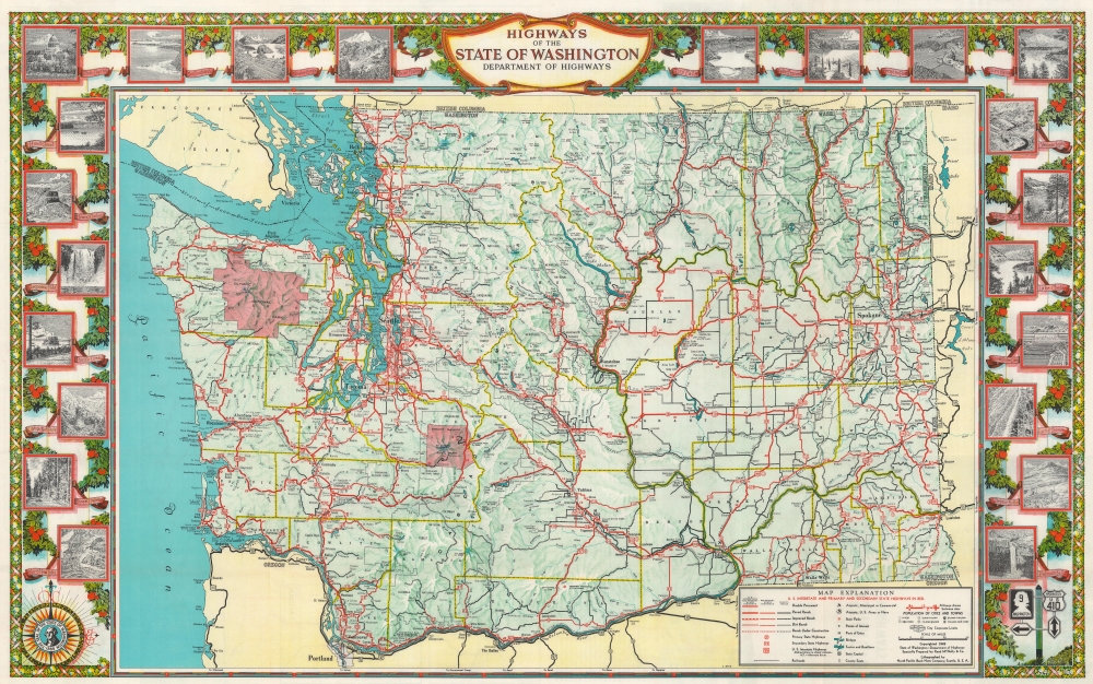
This is a striking 1949 State of Washington Department of Highways pictorial road map of Washington.
A Closer Look
Bright red highlights state highways, with notations indicating road grades (double pavement, paved, improved, and dirt roads). Cities and towns are labeled throughout the state, with Spokane, Seattle, and Tacoma appearing in large bold lettering. Bright red areas highlight Mount Rainier National Park and Olympic National Park. Counties are divided by yellow lines, to allow for differentiation. The whole is surrounded by a pictorial border featuring images of Olympic National Park, Grand Coulee, Mount Rainier, Yakima Canyon, and the Grand Coulee Dam, along with others.Verso Content
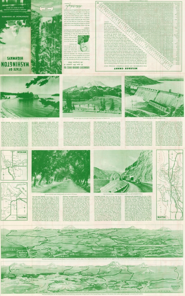
Photographs of Columbia Gorge, Mount Rainier, and Grand Coulee Dam immediately draw the viewer's attention. Small city plans of Spokane, Tacoma, and Seattle also merit a look. However, the panoramas in the bottom quarter of the sheet are exceptional and present Washington as it appears looking both east over the Olympic Peninsula and west over central Washington to Mount Rainier.Publication History and Census
This map was prepared by Rand McNally and Company, lithographed by the North Pacific Bank Note Company, and published in 1949 by the State of Washington Department of Highways. We note nine examples cataloged in OCLC, however, due to cataloging inconsistencies, it is evident that all nine examples present in the OCLC record for this map do not represent the 1949 edition. Editions were published in 1939, 1941, 1942, 1944, and 1949 (all of which have been digitized by the Washington State Department of Transportation Library) and the map appears to be unchanged while the verso content differs. Nonetheless, the map is scarce on the market.Cartographer
Rand, McNally and Co. (fl. 1856 - present) is an American publisher of maps, atlases and globes. The company was founded in 1856 when William H. Rand, a native of Quincy, Massachusetts, opened a print shop in Chicago. Rand hired the recent Irish immigrant Andrew McNally to assist in the shop giving him a wage of 9 USD per week. The duo landed several important contracts, including the Tribune's (later renamed the Chicago Tribune) printing operation. In 1872, Rand McNally produced its first map, a railroad guide, using a new cost effective printing technique known as wax process engraving. As Chicago developed as a railway hub, the Rand firm, now incorporated as Rand McNally, began producing a wide array of railroad maps and guides. Over time, the firm expanded into atlases, globes, educational material, and general literature. By embracing the wax engraving process, Rand McNally was able to dominate the map and atlas market, pushing more traditional American lithographic publishers like Colton, Johnson, and Mitchell out of business. Eventually Rand McNally opened an annex office in New York City headed by Caleb S. Hammond, whose name is today synonymous with maps and atlases, and who later started his own map company, C. S. Hammond & Co. Both firms remain in business. More by this mapmaker...
Condition
Very good. Light wear along original fold lines. Text and printed images on verso.
References
Washington State Department of Transportation Library WA 388 H531hm 1949. OCLC 865003607.