This item has been sold, but you can get on the Waitlist to be notified if another example becomes available, or purchase a digital scan.
1933 Karl Smith Pictorial Map of Kentucky
HistoricalKentucky-karlsmith-1933$175.00

Title
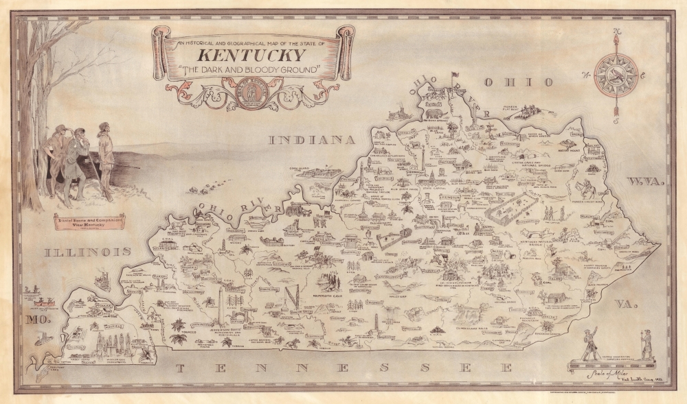
An Historical and Geographical Map of the State of Kentucky 'The Dark and Bloody Ground'.
1933 (dated) 13 x 22.25 in (33.02 x 56.515 cm) 1 : 1267200
1933 (dated) 13 x 22.25 in (33.02 x 56.515 cm) 1 : 1267200
Description
This is Karl Smith's 1933 Depression Era pictorial map of Kentucky. Issued at the height the Great Depression, the map offers a much needed boost to state and national morale.
A Closer Look
The map highlights important locations across Kentucky and promotes state heritage through pictorial vignettes. Historic birthplaces, gravesites, and monuments appear alongside illustrations of Kentucky's universities, cathedrals, and Churchill Downs. Mammoth Cave merits special attention, as does Corn Island, the first settlement of what became Louisville. Banners label towns. A vignette of Daniel Boone and his companions appears along the left border.Historical Context
When this map was issued, Kentucky, like much of the United States, was deeply entrenched in the throes of the Great Depression, a period marked by economic hardship, widespread unemployment, and social unrest. The state's economy, heavily reliant on agriculture and coal mining, suffered as crop prices plummeted and industrial demand waned, leading to significant job losses and poverty among its populace. The hardships faced by Kentuckians during this era were compounded by environmental challenges, including devastating floods that damaged property and agricultural lands, further straining the struggling communities. It was a time of significant adversity, prompting both state and federal government intervention aimed at providing relief and support through various New Deal programs, which sought to alleviate the economic distress and rebuild the state's infrastructure, laying the groundwork for recovery and future growth.Publication History and Census
This map was drawn and published by Karl Smith in 1933. We note three examples cataloged in OCLC: Ball State University, the University of Kentucky, and the Allen County Public Library in Fort Wayne, Indiana. A later edition published in 1939 features an illustration of racehorses below the bottom border.Cartographer
Karl J. Smith (August 28, 1895 - August 7, 1986) was an American cartographer and illustrator best known for his pictorial maps. Smith was born in Louisville, Kentucky. His first job was at Louisville Paper Company - where he apparently fell into a barrel of ink. He served in World War I (1914 - 1918). His earliest work dates to about 1934, when he was commissioned by the Speed Art Museum of Louisville, Kentucky to make pictorial maps of the states. It is unclear if he completed this project, but known maps include Kentucky, Indiana, Illinois, Ohio, Michigan, North Carolina, Arkansas, Mississippi, Florida, and California. There are likely others. Around 1950, he relocated to Greensboro, North Carolina, where he worked as advertising director for the Dillard Paper Company. Later, in the late 1950s, he issued a series of historical maps of the United States for Linweave Paper Company. Smith's style resembles that of Ernest Dudley Chase but is more playful and humorous. In addition to cartographic work, he was also considered an expert on heraldic painting. He was also an amateur historian and well-known expert on Benjamin Franklin. Smith died in Louisville, Kentucky, at 90. More by this mapmaker...
Condition
Good. Dampstaining to left margin entering printed image in bottom left corner and along left border. Overall toning.
References
OCLC 8102112.