This item has been sold, but you can get on the Waitlist to be notified if another example becomes available, or purchase a digital scan.
1950 Rand McNally Pictorial Map of Florida
HistoricalScenicFlorida-randmcnally-1950$87.50


Title
Historical Scenic Map of Florida.
1950 (undated) 14 x 22 in (35.56 x 55.88 cm) 1 : 3065040
1950 (undated) 14 x 22 in (35.56 x 55.88 cm) 1 : 3065040
Description
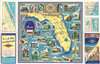
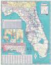
This is a c. 1950 Rand McNally pictorial map of Florida. Pictorial vignettes highlight twenty-four historic sites across Florida from Pensacola to the Overseas Highway. These sites include the first schoolhouse in the United States in St. Augustine, the Fountain of Youth reportedly visited by Ponce de Leon, the Ringling Art Museum, Fort Barrancas, and old Fort San Carlos in Pensacola, and the State Capitol Building in Tallahassee. Small city plans accompany the central pictorial map along the left and right sides and detail Daytona Beach, Miami, and West Palm Beach. A highway road map of Florida occupies the verso and includes a mileage chart and insets of Tampa and St. Petersburg, Jacksonville, and the Florida Panhandle.
Dating the Map
This particular example bears a faded ink stamp from the Carl Eagerton Garage in Orlando, Florida. We have found one reference to the Carl Eagerton Garage, in the July 2, 1950 edition of the Tampa Tribune. We also located an earlier example of the Historical Scenic Map of Florida in the Touchton Map Library at the Tampa Bay History Center. By combining these two pieces of information, we arrived at the c. 1950 publication date.Publication History and Census
This map was created by Rand McNally 'especially for the Sun Oil Company'. As stated above, we have located an earlier edition from 1948 that is part of the Touchton Map Collection at the Tampa Bay Historical Society, and the OCLC catalogs three examples of a 1941 edition. We have not located any other examples of the present edition.Cartographer
Rand, McNally and Co. (fl. 1856 - present) is an American publisher of maps, atlases and globes. The company was founded in 1856 when William H. Rand, a native of Quincy, Massachusetts, opened a print shop in Chicago. Rand hired the recent Irish immigrant Andrew McNally to assist in the shop giving him a wage of 9 USD per week. The duo landed several important contracts, including the Tribune's (later renamed the Chicago Tribune) printing operation. In 1872, Rand McNally produced its first map, a railroad guide, using a new cost effective printing technique known as wax process engraving. As Chicago developed as a railway hub, the Rand firm, now incorporated as Rand McNally, began producing a wide array of railroad maps and guides. Over time, the firm expanded into atlases, globes, educational material, and general literature. By embracing the wax engraving process, Rand McNally was able to dominate the map and atlas market, pushing more traditional American lithographic publishers like Colton, Johnson, and Mitchell out of business. Eventually Rand McNally opened an annex office in New York City headed by Caleb S. Hammond, whose name is today synonymous with maps and atlases, and who later started his own map company, C. S. Hammond & Co. Both firms remain in business. More by this mapmaker...
Condition
Very good. Exhibits light wear along original fold lines. Folds out to road map of Florida on verso.