This item has been sold, but you can get on the Waitlist to be notified if another example becomes available, or purchase a digital scan.
1887 Depot de la Marine Map or Nautical Chart of Belgium and Holland
HollandBelgium-depot-1887$87.50

Title
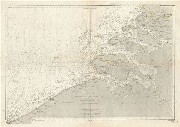
Mer du Nord Cotes de Belgique et de Hollande (Entre la Frontiere Francaise et Hoek van Holland).
1887 (dated) 26 x 37 in (66.04 x 93.98 cm) 1 : 169000
1887 (dated) 26 x 37 in (66.04 x 93.98 cm) 1 : 169000
Description
This is a rare and beautiful nautical chart or map of Holland and Belgium issued in 1887 by the Depot de la Marine. It covers the coast of Holland and Belgium from Dunkirk on the French border to Hoek van Holland. The chart offers extraordinary detail both inland and at sea. In the harbor there are countless depth soundings in meters, references to lights and undersea features such as banks and shoals. Inland there is a wealth of information regarding important cities, canals, roads and topography. This map was originally prepared by the French Depot des Cartes et Plans de la Marine in 1872, the present having been updated by subsequent surveys and corrections to 1887.
Cartographer
Dépôt des Cartes et Plans de la Marine (fl. 1720 - present), often called the Dépôt de Marine, was a French hydrographic mapping organization founded in 1720 under Charles-Hercule of Albert de Luynes (1674 - 1734). Much like the U.S. Coast Survey, the British Admiralty, and the Spanish Deposito Hydrografico, the Dépôt was initiated as a storehouse and distribution center of existing nautical and marine charts. Eventually the Dépôt initiated its own mapping activities in an attempt to improve and expand upon existing material. Some of the more prominent cartographers and hydrographers associated with the of Dépôt des Cartes were, Philippe Buache, Jacques-Nicholas Bellin, Giovanni Rizzi-Zannoni, Rigobert Bonne, and Jean Nicolas Buache. More by this mapmaker...
Condition
Good. Minor wear and toning with verso repair along original fold lines. Blank on verso. Minor spotting here and there. Few pencil marks in lower left quadrant near border.