This item has been sold, but you can get on the Waitlist to be notified if another example becomes available, or purchase a digital scan.
1687 Jan van den Avelen Map of Israel, Palestine, or the Holy Land
HolyLand-avelen-1687$425.00

Title
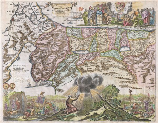
Perigrinatie oste Veertigh-Iarige Reyse der Kinderen Israels, Uyt Egypten door de Roode Zee endede Woestyne tot in't Beloof de Lande Canaan.
1687 (undated) 14.5 x 18.5 in (36.83 x 46.99 cm)
1687 (undated) 14.5 x 18.5 in (36.83 x 46.99 cm)
Description
An absolutely stunning c. 1687 map of the Holy Land, Israel, or Palestine by N. Visscher and Jan van den Avelen. This map, from a Dutch Bible, is oriented to west and covers from the Nile Delta, Cairo and Memphis, egypt, across the Red Sea and along the Mediterranean Coast as far north as Sidon and Tyre (Lebanon), and further inland, Palmyra. Cartographically this map hails from the Nicholas Visscher map of 1650, but it does exhibit some modifications including completely revised topical imagery in the lower quadrants and additional decorative work in the upper right quadrant. Like Visscher's map, our map shows the course of the Israelites as they fled out of egypt, across the Red Sea, and subsequently spent the next forty years wandering in the Sinai before migrating into the Promised Land by crossing the Jordan River just north of the Dead Sea. Mt. Sinai, Mt. Horeb, Sodom, Gomorra, Jerusalem, and countless other importable Biblical locals are noted. In the Mediterranean a fleet of ships is transporting cedar from Sidon to Jaffa for the construction of Solomon's Temple. Also in the Mediterranean, there is an illustration Jonah being swallowed by the whale. These are the only two decorative elements that are inherited directly from Visscher's map of 1650. The elaborate decorative engraving work lower quadrants and in the upper right is the work of Jan van den Avelen, a Dutch engraver active in Amsterdam during the late 17th century. Van den Avelen elaborate illustrations depicts various scenes from exodus including Moses receiving the Tables of Law, the encampments of the Israelites, Moses producing water from a stone, etc. A truly beautiful map and one of the finest maps to appear in a 17th century Bible.
CartographerS
Jan van den Aveelen (1655- May 18, 1727), also called Aveele, was a Dutch sketch artist and engraver active in the late 17th and early 18th centuries. Aveelen was born in Leiden or Amsterdam around 1655. He is known to have worked as an engraver in Utrecht, Leiden, and Amsterdam with various Dutch publishers including Nicholas Visscher. In 1698 Visscher recommended Aveelen to quarter-master general of Sweden Erik Dahlbergh, who hired him to replace the deceased Willem Swiddle, another of Visscher's prodigies. Relocating to Sweden, Aveelen worked on the completing the engravings for Suecia Antiqua et Hodierna, his most significant collection of work. Aveelen died in Stockholm Sweden on May 18, 1727. More by this mapmaker...
Claes Jansz Visscher (1587 - 1652) established the Visscher family publishing firm, which were prominent Dutch map publishers for nearly a century. The Visscher cartographic story beings with Claes Jansz Visscher who established the firm in Amsterdam near the offices of Pieter van den Keer and Jadocus Hondius. Many hypothesize that Visscher may have been one of Hondius's pupils and, under examination, this seems logical. The first Visscher maps appear around 1620 and include numerous individual maps as well as an atlas compiled of maps by various cartographers including Visscher himself. Upon the death of Claes, the firm fell into the hands of his son Nicholas Visscher I (1618 - 1679), who in 1677 received a privilege to publish from the States of Holland and West Friesland. The firm would in turn be passed on to his son, Nicholas Visscher II (1649 - 1702). Visscher II applied for his own privilege, receiving it in 1682. Most of the maps bearing the Visscher imprint were produced by these two men. Many Visscher maps also bear the imprint Piscator (a Latinized version of Visscher) and often feature the image of an elderly fisherman - an allusion to the family name. Upon the death of Nicholas Visscher II, the business was carried on by the widowed Elizabeth Verseyl Visscher (16?? - 1726). After her death, the firm and all of its plates was liquidated to Peter Schenk. Learn More...
Condition
Very good. Even overall toning. A few minor verso repairs. Dutch text on verso.
References
Poorman, W. C. and Augusteijn, J., Kaarten in Bijbels (16e-18e eeuw), #140 (K-II-1). Laor, E., Maps of the Holy Land: Cartobibliography of Printed Maps, 1475-1900, #807.