This item has been sold, but you can get on the Waitlist to be notified if another example becomes available, or purchase a digital scan.
1939 Ho Woo Map of Hong Kong and the New Territories, China
HongKong-howoo-1939$475.00

Title
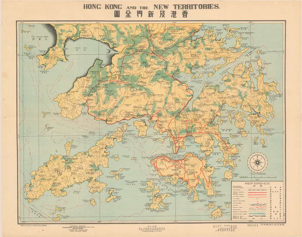
Hong Kong and the New Territories. 香港及新界全圖
1939 (dated) 20.5 x 26.5 in (52.07 x 67.31 cm) 1 : 100000
1939 (dated) 20.5 x 26.5 in (52.07 x 67.31 cm) 1 : 100000
Description
A scarce and well executed bi-lingual map of Hong Kong and the New Territories issued in 1939, or Minguo 28. Centered on Kowloon and Hong Kong Island, coverage extends from the border with mainland China and Tai Chan Wan, south to include all of Lan Tao and Lamma. The cartographer, Kong San (江山), has introduced a sophisticated coding system to illustrate population density, railways, boundaries, motor and military roads, topography, and more. While most text is in English, Chinese content at bottom center advertises a real-estate firm.
Hong Kong in 1939 - on the Cusp of War
Hong Kong in March of 1939 remains an oasis of peace in a sea of war. During the Imperial Japanese military's full-scale invasion of China in 1937, Hong Kong as part of the British Empire, was not targeted for attack. It nonetheless felt the effets of the war as a factor of proximity. Anyone with the ability to do so fled the Japanese invasion, generally to international settlements, extraterritorial possessions, or colonies - among them the still prosperous Hong Kong. Nonetheless, early March 1939, during an Imperial Japanese bombing raid on Shenzhen, a few bombs fell accidentally on Hong Kong territory, destroying a bridge and a train station. When Imperial Japan entered World War II as an Axis power, in December of 1941, one of its first major acts was to launch an invasion of Hong Kong. The Japanese launched an assault on Hong Kong on the morning of 8 December 8, 1941. Facing overwhelming odds, on December 1941, British colonial officials surrendered at the Japanese headquarters, an event known as 'Black Christmas.' Hong Kong remained occupied and under Japanese martial law until the Japanese surrender in 1945.Publication History and Census
This map was drawn by Kong San (江山) and printed in April of 1939 by the Hung Fat Printing Press (香港鸿發印務) in Hong Kong. It was published by Ho Woo Company (厚和公司 / Houhe) of Fung Hoi, Hong Kong. This is the first edition. One example is cataloged in the collections of the Hong Kong University of Science and Technology. No others are known.CartographerS
Kong San (江山; fl. c. 1930 - 1940) was a Chinese draughtsman and cartographer active in Hong Kong in the years prior to World War II (1939 - 1945). He is an elusive figure whose name appears on only a few maps. More by this mapmaker...
Ho Woo Company (厚和公司; fl. c. 1930 - 1940), properly Houhe, was a Chinese publisher based in Hong Kong in the years prior to World War II (1939 - 1945). Learn More...
Hung Fat Printing Company (鴻發印務; fl. c. 1930 - 1940), properly Hongfa, was a Chinese owned and operated printing concern based in Hong Kong at 19 Luard Road during the years prior to World War II (1939 - 1945). Learn More...
Condition
Very good. Minor wear on old fold lines. Edge wear.
References
OCLC 8159875330. Hong Kong University of Science and Technology, G7823.H45 1939 K65.