This item has been sold, but you can get on the Waitlist to be notified if another example becomes available, or purchase a digital scan.
1757 Bellin Map of South Africa and the Cape of Good Hope
Hottentoten-bellin-1757$162.50

Title
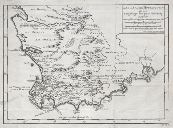
Das Land der Hottentoten an dem Vorgebrige der guten Hoffnung.
c. 1747 (undated) 9.5 x 13.5 in (24.13 x 34.29 cm)
c. 1747 (undated) 9.5 x 13.5 in (24.13 x 34.29 cm)
Description
A very scarce example of Bellin's 1747 map of southern Africa and the Cape of Good Hope. Covers from the Bay of St. Helena to Mussel Bay. Dutch settlements appear along the coast line with African tribal regions dominating the interior. Features excellent geographical detail, referencing swamps, mountains, forests and rivers. While the French edition of this map appears with some regularity, this, the German edition, is extremely rare. Compared to the French and Italian editions it is printed on much heavier stock and has a much darker impression. From the German edition of Provost's Voyages, edited and published by Johann Joachim Schwabe, Allgemeine Historie der Reisen zu Wasser und zu Lande (General History of Travel over Water and Land) .
Cartographer
Jacques-Nicolas Bellin (1703 - March 21, 1772) was one of the most important cartographers of the 18th century. With a career spanning some 50 years, Bellin is best understood as geographe de cabinet and transitional mapmaker spanning the gap between 18th and early-19th century cartographic styles. His long career as Hydrographer and Ingénieur Hydrographe at the French Dépôt des cartes et plans de la Marine resulted in hundreds of high quality nautical charts of practically everywhere in the world. A true child of the Enlightenment Era, Bellin's work focuses on function and accuracy tending in the process to be less decorative than the earlier 17th and 18th century cartographic work. Unlike many of his contemporaries, Bellin was always careful to cite his references and his scholarly corpus consists of over 1400 articles on geography prepared for Diderot's Encyclopedie. Bellin, despite his extraordinary success, may not have enjoyed his work, which is described as "long, unpleasant, and hard." In addition to numerous maps and charts published during his lifetime, many of Bellin's maps were updated (or not) and published posthumously. He was succeeded as Ingénieur Hydrographe by his student, also a prolific and influential cartographer, Rigobert Bonne. More by this mapmaker...
Source
Johann Joachim Schwabe, Allgemeine Historie der Reisen zu Wasser und zu Lande, c. 1747.
Condition
Good conditon. Original folds. Minor old verso repair on the left margin in extending slightly into the map, lower left quadrant. Older verso reinforcemtn on original fold line in lower right quadrant.