This item has been sold, but you can get on the Waitlist to be notified if another example becomes available, or purchase a digital scan.
1904 Kisaburō Ohara Satirical Octopus Map of Asia and Europe
HumorousDiplomaticAtlas4-ohara-1904$2,750.00

Title
A Humorous Diplomatic Atlas of Europe and Asia. / 滑稽欧亜外交地図 / Kokkei Ō-A Gaikō Chizu.
1904 (dated) 16.5 x 22.5 in (41.91 x 57.15 cm) 1 : 21710000
1904 (dated) 16.5 x 22.5 in (41.91 x 57.15 cm) 1 : 21710000
Description
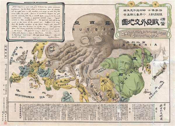
A wonderful example of the rare 1904 Kisaburō Ohara / Shingo Nakamura satirical 'Octopus Map' of Europe. Composed at the outbreak of the Russo-Japanese War (1904 - 1905), Ohara here follows the conventions established by J. J. van Brederode ( Humoristische-Oorlogskaart, 1870) and Fred Rose (Serio-Comic War Map, 1877). These two maps established the convention of satirizing Russian expansionism as a menacing Kraken-like 'Black Octopus.' Whereas Brederode and Rose confine their images to Russia, Ohara has here expanded the idea to encompass all of Eurasia. Russia's eight grasping tentacles extend across Europe and Asia; on many countries they already have a firm grip. Finland, Poland, Crimea, and the Balkan nations are represented as skulls, while tentacles grasp Turkey around the foot and waist, Persia about the neck, and Tibet by the arm. The Trans-Siberian Railway and the South Manchuria Railway, represented by the rightmost tentacle, had by this time extended Russian influence into Manchuria as far as the valuable ice-free Russian stronghold of Port Arthur. As this map was issued in March of 1904, the struggle between Russian and Japan over control of Port Arthur was ongoing. Port Arthur was surrendered to the Japanese, who defeated the Russian Fleet in December of 1905, several months after this map was printed. Ohara sums up the situation in his English language descriptions of the map, printed in the upper left,
The map is also known to have spread to the Japanese community in the United States. Copies of the map that made their way to Honolulu were being promoted in the April 30th, 1904 Pacific Commercial Advertiser.
Moreover, the map also clearly expresses Japanese Imperial intentions. The English content boldly suggests that the Japanese may well advance as far as St. Petersburg. Taiwan/Formosa is a cannon aimed towards Southeast Asia. In terms of the geographical representation of central Asia, it is noteworthy that China's borders are not that of Qing China, but rather are severely limited, excluding Chinese claims to Tibet and Turkestan.
There was initially some attempt at negotiation between the imperialist powers, but Tsar Nicholas II arrogantly believed it impossible that Japan could challenge a major European power. Japan proved him wrong, launching a surprise attack on the Russian Eastern Fleet stationed at Port Arthur. Throughout the course of the war, the Russians were defeated again and again, humiliating the Tsar and forcing U.S. President Theodore Roosevelt to arbitrate a peace, confirmed by the Treaty of Portsmouth. The treaty recognized Japan's claims on Korea and called for the evacuation of Russian forces from Manchuria, including from Port Arthur.
The overwhelming victory of Imperial Japan came as a surprise to international observers, being the first major military victory in the modern era of an Asian over European power. The consequences transformed the balance of power, confirmed Japan as the pre-eminent power in East Asia.
Black Octopus is a name newly given to Russia by a certain prominent Englishman. For the black octopus is so avaricious, that he stretches out his eight arms in all directions, and seizes up every thing that comes within his reach. But as it sometimes happens he gets wounded seriously even by a small fish, owing to his too much covetousness. Indeed, a Japanese proverb says: 'Great avarice is like unselfishness.' We Japanese need not to say much on the cause of the present war. Suffice it to say that the further existence of the Black Octopus will depend entirely upon how he comes out of this war. The Japanese fleet has already practically annihilated Russia's naval powers in the Orient. The Japanese army is about to win a signal victory over Russia in Corea and Manchuria. And when ... St. Petersburg? Wait and see! The ugly Black Octopus! Hurrah! Hurrah! for Japan.Certainly the map had a strong message, but who saw it?
International Influence
It has been argued by New York collector P. J. Mode, and others, that this map was probably intended for an English as much as a Japanese audience. He reminds us that the Russo-Japanese war was primarily a naval engagement. The map served as a warning to the British – stay out of the war. By April of 2004, one month before Ohara printed this map, the Japanese had already defeated the Russian Navy. Only foreign influence, potentially in the form of the powerful British navy, could have prevented them from taking Port Arthur.The map is also known to have spread to the Japanese community in the United States. Copies of the map that made their way to Honolulu were being promoted in the April 30th, 1904 Pacific Commercial Advertiser.
Moreover, the map also clearly expresses Japanese Imperial intentions. The English content boldly suggests that the Japanese may well advance as far as St. Petersburg. Taiwan/Formosa is a cannon aimed towards Southeast Asia. In terms of the geographical representation of central Asia, it is noteworthy that China's borders are not that of Qing China, but rather are severely limited, excluding Chinese claims to Tibet and Turkestan.
Russo-Japanese War
The Russo-Japanese War, fought from February 8, 1904 - September 5, 1905, pitted Imperial Japan against Tsarist Russia over rival imperial ambitions in Manchuria and Korea. Both Russia and Japan had grand visions for the region. Russia traditionally had only one Pacific port, Vladivostok, which was operational only during the warm summer months. In 1898, Russia coerced China, then weakened after the First Sino-Japanese War (1894 - 1895), to lease Port Arthur, a warm water port on the Liaodang Peninsula. They also negotiated a right-of-way to connect Port Arthur to the China Eastern Railway, which ran from nearby Dalian (Dalny) to Harbin, a stop on the Siberian Railway. Russia, eager to expand southwards from Siberia, considered Port Arthur the cornerstone of a sphere of influence covering China, Manchuria, and Korea. Japan had its own Imperial ambitions and saw itself as the natural overlord in East Asia. Korea and Manchuria in particular were important as steppingstones into China, with its seemly unlimited resources.There was initially some attempt at negotiation between the imperialist powers, but Tsar Nicholas II arrogantly believed it impossible that Japan could challenge a major European power. Japan proved him wrong, launching a surprise attack on the Russian Eastern Fleet stationed at Port Arthur. Throughout the course of the war, the Russians were defeated again and again, humiliating the Tsar and forcing U.S. President Theodore Roosevelt to arbitrate a peace, confirmed by the Treaty of Portsmouth. The treaty recognized Japan's claims on Korea and called for the evacuation of Russian forces from Manchuria, including from Port Arthur.
The overwhelming victory of Imperial Japan came as a surprise to international observers, being the first major military victory in the modern era of an Asian over European power. The consequences transformed the balance of power, confirmed Japan as the pre-eminent power in East Asia.
The Shingo Nakamura Connection
The map is generally attributed to Kisaburō Ohara, but the publisher, Shingo Nakamura (中村進午; 1870 - 1939) is a far better known. He was a professor of law at the Tokyo Gakushuin (學習院)and later at Hôsei (法政大學)University. Nakamura was a polarizing figure who studied in both England and France before teaching in Tokyo. As a member of the nationalist anti-Russian Tomizu Group, he strongly advocated for a no-tolerance Russia policy. His strongly vocalized opinions led him to lose his position as a professor. It seems possible, even likely, that it was Nakamura, with a background in England, who introduced the serio-comic map to Ohara and orchestrated its production / publication. Certainly, it seems likely that either student or professor would have had the financial wherewithal to publish this lavish chromolithograph map. More likely publication was financed by fellow Tomizu Group members, among them a Duke Konoe Atsumaro (近衛 篤麿, 1863 - 1904), founder in 1903 of the Anti-Russia Society (対露同志会; Tairo Dōshikai).Chromolithography
Chromolithography is a color lithographic technique developed in the mid-19th century. The process involved using multiple lithographic stones, one for each color, to yield a rich composite effect. Oftentimes, the process would start with a black basecoat upon which subsequent colors were layered. Some chromolithographs used 30 or more separate lithographic stones to achieve the desired effect. Chromolithograph color could also be effectively blended for even more dramatic results. The process became extremely popular in the late 19th and early 20th centuries, when it emerged as the dominate method of color printing. The vivid color chromolithography produced made it exceptionally effective for advertising and propaganda imagery.Japanese Serio Comic Maps of the Russo-Japanese War
Although Serio-Comic maps were common in Europe from at least the 1860s, they were first discovered by Japanese artists and printers during the Russo-Japanese War, when they became popular tools for both internal propaganda and communicating Japanese solidarity with European powers, specifically England. Five Japanese Serio-Comic maps were issued to illustrate the Russo-Japanese War at different points. They are issued by different artists and publishers, but appear sequentially, by month, suggesting central planning - possibly the Tomizu Group or Anti-Russian Society (対露同志会). All are rare, but the first map in the series, by Kisaburō Ohara and Shingo Nakamura, is the most common. The others are exceedingly scarce. We offer a breakdown of known maps from this series,- April 1904 - Kisaburō Ohara / 小原喜三郎 - A Humorous Diplomatic Atlas of Europe and Asia / 滑稽欧亜外交地圖.
- May 3, 1904 - Nakayama Kyūshirō / 中山久四郎 - New Commemorative Print of Various Countries Sympathies in the Russo Japanese War. / 崭新纪念画 日露戰爭列國义同情.
- May 1904 - Unknown - Humor Reproach Candition Map of Europe and Asia. / 滑稽諷刺歐亞形勢圖
- June 1904 - Kamijo Yomotaro - New Comical Atlas / 滑稽万国形勢新地圖.
- July 1904 - Haru EiDō / 春榮堂- New Funny Map of Europe and Asia / 亞細亞歐羅巴嶄新滑稽地圖.
Publication History and Census
This map was drawn by Kisaburō Ohara while a student at Keiō Gijuku University. It was published by Shingo Nakamura and engraved by the Tokyo printer Yabuki Yoshijiro. The map is rare by any standard with only two institutional collection examples identified by the OCLC. Although there has been no known study of the various editions of this map, at least 5 are known, this being the 3rd. Cartographically all states are identical.CartographerS
Ohara Kisaburō (小原喜三郎; c. 1885 - 1949) was a prominent Japanese legal scholar active during the late Meiji, Taishō, and early Shōwa periods, known for his expertise in commercial law, particularly in negotiable instruments (手形, tegata) and banking practices (銀行実務, ginkō jitsumu). He is associated with one map, A Humorous Diplomatic Atlas of Europe and Asia (滑稽欧亜外交地図 / Kokkei Ō-A Gaikō Chizu), likely produced when he was a student at Keio University (慶應義塾大學) or a graduate student or junior professor at Tokyo Gakushuin (學習院). He later became a professor at Tokyo Imperial University (東京帝国大学, Tōkyō Teikoku Daigaku). He played a key role in modernizing Japan's financial legal system by integrating Western legal theory with Japanese practice. One of his best-known works, 『手形及銀行實務: 英語對照』 (Tegata oyobi Ginkō Jitsumu: Eigo Taishō, Bills and Banking Practices: With English Translation), provided a bilingual reference for legal and financial professionals during Japan's period of internationalization. His work contributed significantly to the development of Japan's legal infrastructure for banking and finance, influencing the standardization of laws concerning promissory notes (約束手形, yakusoku tegata) and bills of exchange (為替手形, kawase tegata). More by this mapmaker...
Nakamura Shingo (中村進午, なかむら しんご; August 17, 1870 - October 31, 1939) was a Japanese lawyer, academic, and publisher active in Japan. Nakamura was born in Takada, Niigata Prefecture, Japan. He studied law at the Tokyo Imperial University. He traveled widely, studying international law and policy in Germany, England, and France before returning to Japan to take a professor of law position at the Tokyo Gakushuin (學習院). He was a member of the nationalist anti-Russian Tomizu Group and publicly advocated for a no-tolerance policy toward Russia - a controversial position that led him to lose his Gakushuin professorship. and later at Hôsei (法政大學) University. In 1906 (Meiji 39), after the Russo-Japanese War (1904 - 1905), he became a professor at Tokyo Higher School of Commerce (Hitotsubashi University), where he remained, later as a Professor Emeritus, until 1938, the year before his death. Learn More...
Condition
Good. Some damage and loss near Japan, at bottom margin, and slight repaired loss to text block below Siam. Backed on archival tissue.
References
Persuasive Maps: PJ Mode Collection, 1145. Boston Public Library, Leventhal Center, G5690 1904 .O33. Baynton-Williams, A., The Curious Map Book, page 196. OCLC 498191044.