1725 Seutter Map of Hungary
Hungary-seutter-1725$650.00

Title
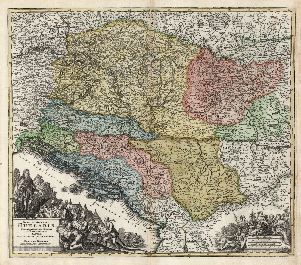
Nova et Accurata Hungariae cum Adiacentibus Regnis et Principatibus Tabula, Aeri Incisa et Venum Exposita À Matthaeo Seütter, Chalcographo Augustano.
1725 (undated) 19.25 x 22.5 in (48.895 x 57.15 cm) 1 : 2100000
1725 (undated) 19.25 x 22.5 in (48.895 x 57.15 cm) 1 : 2100000
Description
This is an early 18th century Matthias Seütter map of Hungary and its borderlands. The map follows Habsburg victories over the Ottoman Empire, resulting in the absorption of Ottoman lands by Hungary. It is among Seütter early corpus, prior to his becoming official cartographer for the Holy Roman Emperor - though likely no earlier than 1718, at which point most of the territorial acquisitions mapped here had been set by treaty.
Scope
The map, centered on Belgrade, embraces the territories on both banks of the Danube well above Vienna, and just below Nicopolis. The Dalmatian coast is covered, from Croatia down to the coast of Albania. The map thus includes Hungary, Sclavonia, Bosnia, Serbia, Bulgaria, Transylvania, Wallachia, and the southern parts of Moravia and Poland.A Martial Cartouche
Rogg's dramatic cartouche celebrates the Habsburg Empire's triumphs over the Ottoman Empire at the end of the 17th and the beginning of the 18th centuries. A Habsburg Emperor - either Charles VI or his brother Joseph I - stands armored, scepter in hand, to receive the tribute of his new possessions: these are represented by seven figures, each submitting the arms of their respective kingdoms: Dalmatia, Hungary, Croatia, Bosnia, Transylvania, Serbia, and Sclavonia. In the background, a battle still rages. To the lower right, a scale cartouche illustrates fertility with a happy cluster of allegorical figures: an elderly man with a flowing jug represents the Danube itself; a central figure possibly representing Europe sits demurely with a sailing ship on her lap, surrounded by a lively pack of maenads (signified by abundant grape vines).Publication History and Census
This map was engraved for Matthias Seutter by Gottfried Rogg, certainly prior to the 1727 production of Seutter's Atlas Novus. We are aware of two states of this map, which after 1732 was entirely reengraved without Rogg's imprint, but including of Seutter's new title as Imperial Geographer in the cartouche. The map appears on the market in its various iterations, and is listed in various institutional collections; however, it is difficult to determine specific editions due to imprecise cataloging.CartographerS
Matthäus Seutter (1678 - 1757) was one of the most important and prolific German map publishers of the 18th century. Seutter was born the son of a goldsmith but apprenticed as a brewer. Apparently uninspired by the beer business, Seutter abandoned his apprenticeship and moved to Nuremberg where he apprenticed as an engraver under the tutelage of the prominent J. B. Homann. Sometime in the early 1700s Seutter left Homann to return to Augsburg, where he worked for the prominent art publisher Jeremiad Wolff (1663 - 1724), for whom he engraved maps and other prints. Sometime around 1717 he established his own independent cartographic publishing firm in Augsburg. Though he struggled in the early years of his independence, Seutter's engraving skill and commitment to diversified map production eventually attracted a substantial following. Most of Seutter's maps are heavily based upon, if not copies of, earlier work done by the Homann and De L'Isle firms. Nonetheless, by 1731/32 Seutter was one of the most prolific publishers of his time and was honored by the German Emperor Karl VI who gave him the title of Imperial Geographer, after which most subsequent maps included the Avec Privilege designation. Seutter continued to publish until his death, at the height of his career, in 1757. Seutter had two engraver sons, Georg Matthäus Seutter (1710 - 173?) and Albrecht Carl Seutter (1722 - 1762). Georg Matthäus quit the business and relocated to Woehrdt in 1729 (and probably died shortly thereafter), leaving the family inheritance to his wastrel brother Albrecht Carl Seutter, who did little to advance the firm until in own death in 1762. Following Albrecht's death, the firm was divided between the established Johann Michael Probst (1727 - 1776) firm and the emerging firm of Tobias Conrad Lotter. Lotter, Matthäus Seutter's son-in-law, was a master engraver and worked tirelessly on behalf of the Suetter firm. It is Lotter, who would eventually become one of the most prominent cartographers of his day, and his descendants, who are generally regarded as the true successors to Matthäus Seutter. (Ritter, M. Seutter, Probst and Lotter: An Eighteenth-Century Map Publishing House in Germany., "Imago Mundi", Vol. 53, (2001), pp. 130-135.) More by this mapmaker...
Gottfried Rogg (1669-1742) was an Augsburg goldsmith, engraver and publisher. He was known for his decorative engraving, in particular having engraved a large number of the maps for Matthias Seutter’s atlases. Learn More...
Source
Seutter, M., Atlas Geographicus, (Augsburg: Suetter) 1725.
Condition
Good. Centerfold mended with some scuffing; few areas of faint soiling. Else very good.
References
OCLC 159888343. Rumsey 12041.062 (1727, same plate but subsequent state with coordinate grid).