This item has been sold, but you can get on the Waitlist to be notified if another example becomes available, or purchase a digital scan.
1747 Bowen Map of Hungary and Transylvania (Romania)
HungaryRomania-bowen-1747$100.00

Title
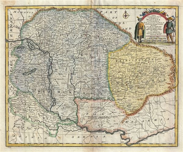
A New and Accurate Map of the Kingdom of Hungary and Principality of Transilvania with the Bordering Countries.
1747 (undated) 14 x 17 in (35.56 x 43.18 cm) 1 : 650000
1747 (undated) 14 x 17 in (35.56 x 43.18 cm) 1 : 650000
Description
An attractive 1747 map of Hungary and Transylvania (part of modern day Romania) by the British cartographer Emanuel Bowen. The map covers the region from the Carpathian Mountains south as far as the Danube River, including parts of modern day Hungary, Romania, Slovakia, and Serbia. Several towns, rivers, mountains, roads and other topographic features are noted. Color coded according to territories and regions, mountains are beautifully rendered in profile. The map identifies a 'Roman Camp' northwest of Belgrade. The region of Temeswar is noted to be 'Ceded to the House of Austria by the Treaty of Belgrade 1739.' The Treat of Belgrade, a peace treaty between the Hasburg Monarchy and the Ottoman Empire, was signed post the Austro-Russian-Turkish War of 1735-1739. A title cartouche is included in the upper right quadrant of the map that includes a beautiful illustration of two noblemen. This map was prepared by Emanuel Bowen as plate no. 30 for the 1747 issue of A Complete System of Geography.
Cartographer
Emanuel Bowen (1694 - May 8, 1767) had the high distinction to be named Royal Mapmaker to both to King George II of England and Louis XV of France. Bowen was born in Talley, Carmarthen, Wales, to a distinguished but not noble family. He apprenticed to Charles Price, Merchant Taylor, from 1709. He was admitted to the Merchant Taylors Livery Company on October 3, 1716, but had been active in London from about 1714. A early as 1726 he was noted as one of the leading London engravers. Bowen is highly regarded for producing some of the largest, most detailed, most accurate and most attractive maps of his era. He is known to have worked with most British cartographic figures of the period including Herman Moll and John Owen. Among his multiple apprentices, the most notable were Thomas Kitchin, Thomas Jeffreys, and John Lodge. Another apprentice, John Oakman (1748 - 1793) who had an affair with and eventually married, Bowen's daughter. Other Bowen apprentices include Thomas Buss, John Pryer, Samuel Lyne, his son Thomas Bowen, and William Fowler. Despite achieving peer respect, renown, and royal patronage, Bowen, like many cartographers, died in poverty. Upon Emanuel Bowen's death, his cartographic work was taken over by his son, Thomas Bowen (1733 - 1790) who also died in poverty. More by this mapmaker...
Source
Bowen, E., A Complete System of Geography. Being a description of all the countries, islands, cities, chief towns, harbours, lakes, and rivers, mountains, mines, etc., of the known world …, (London) 1747.
Condition
Very good. Minor wear along original fold lines. Original platemark visible. Blank on verso. Overall age toning.
References
Rumsey 3733.029. Philips (atlases) 614 (1752 edition).