This item has been sold, but you can get on the Waitlist to be notified if another example becomes available, or purchase a digital scan.
1910 Rand McNally Pocket Map of Idaho
Idaho-randmcnally-1910$150.00

Title
Idaho.
1910 (dated) 19.5 x 13.25 in (49.53 x 33.655 cm) 1 : 1647360
1910 (dated) 19.5 x 13.25 in (49.53 x 33.655 cm) 1 : 1647360
Description
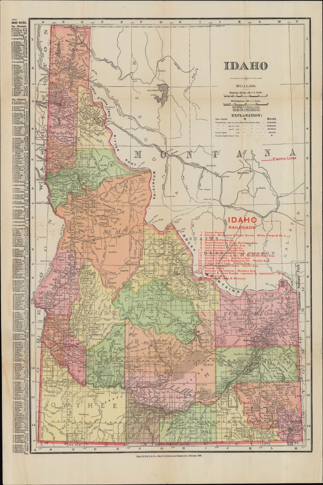
A colorful folding pocket map of Idaho, published in 1910 by Rand McNally and Co.
A Closer Look
The entire state of Idaho is displayed with counties color-shaded and township lines drawn, as are lines along full latitudes and longitudes. Counties, cities, towns, Indians Reservations, railroads, waterways, and notable physical features are labelled throughout. An alphanumeric grid surrounds the map, corresponding to an index of cities and towns at left. A red overprint table at right lists railroad lines, with the Spokane and Inland Empire Railroad, reaching Moscow and Coeur d'Alene being noted for operating on electricity. Two other electric lines appear further south, representing the Boise Valley Electric Railroad and the Nez Perce and Idaho Railroad.Historical Context
Around the time of this map's publication, Idaho's economy was undergoing a partial transition from mining to agriculture. Mining towns, such as Cottonwood, Mount Idaho, and Rockybar indicated here, which had been founded following the discovery of gold in the 1860s, were already well on their way to becoming ghost towns. Meanwhile, the Milner Dam east of Twin Falls aided agricultural development in the state's south, as did the proposed Twin Falls Canal System west of the namesake city, which was built beginning in 1909 and has been operated by the Twin Falls Canal Company ever since.Publication History and Census
This map is dated 1910 and appeared in Rand McNally and Co's indexed county and township pocket map and shippers' guide of Idaho. It is well-represented in institutional collections but scarce to the market.Cartographer
Rand, McNally and Co. (fl. 1856 - present) is an American publisher of maps, atlases and globes. The company was founded in 1856 when William H. Rand, a native of Quincy, Massachusetts, opened a print shop in Chicago. Rand hired the recent Irish immigrant Andrew McNally to assist in the shop giving him a wage of 9 USD per week. The duo landed several important contracts, including the Tribune's (later renamed the Chicago Tribune) printing operation. In 1872, Rand McNally produced its first map, a railroad guide, using a new cost effective printing technique known as wax process engraving. As Chicago developed as a railway hub, the Rand firm, now incorporated as Rand McNally, began producing a wide array of railroad maps and guides. Over time, the firm expanded into atlases, globes, educational material, and general literature. By embracing the wax engraving process, Rand McNally was able to dominate the map and atlas market, pushing more traditional American lithographic publishers like Colton, Johnson, and Mitchell out of business. Eventually Rand McNally opened an annex office in New York City headed by Caleb S. Hammond, whose name is today synonymous with maps and atlases, and who later started his own map company, C. S. Hammond & Co. Both firms remain in business. More by this mapmaker...
Source
Rand McNally and Co's indexed county and township pocket map and shippers' guide of Idaho: accompanied by a new and original compilation and ready reference index, showing in detail the entire railroad system, the express company doing business over each road, and accurately locating all cities, towns, post offices, railroad stations, villages, counties, islands, lakes, rivers, etc., (Chicago) 1910.
Condition
Good. Wear along original fold lines. Verso repairs at fold intersections.
References
OCLC 818644442.