This item has been sold, but you can get on the Waitlist to be notified if another example becomes available, or purchase a digital scan.
1634 Blaeu Map of the Île-de-France
IleDeFrance-blaeu-1634$200.00

Title
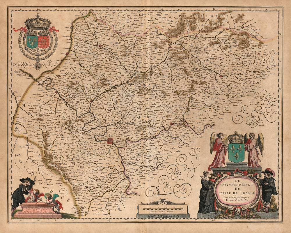
Le Gouvernement de L'Isle de France Par Damien de Templeux Escuyer Sr. du Frestoy.
1634 (undated) 16 x 20.5 in (40.64 x 52.07 cm) 1 : 360000
1634 (undated) 16 x 20.5 in (40.64 x 52.07 cm) 1 : 360000
Description
This is Willem Blaeu's 1634 map of the Île-de-France, surrounding Paris.
A Closer Look
The map is oriented to the north and is loosely centered on Paris. The River Seine and its tributaries and surrounding forested regions are indicated pictorially. Vernon and Pacy-sur-Eure appear at the northwest limit of the map, and Noyon, La Fère, and Laon can be found to the northeast. Étampes and Melun are at the southern part of the map.A Beautiful Engraving
The map is richly decorative. The Grand Royal Coat of Arms of France and Navarre is displayed in the upper left. The title cartouche at lower right - overflowing with fruit - is topped with the arms of France, flanked by two robed angels (robed in fleurs de lís) and attended by a French Cavalier and noblewoman. At the lower left, another cavalier with a surveyors' rod appears to be instructing a pair of putti in the use of a compass.Source
Blaeu's map is credited to Damien de Templeux, a French cartographer who produced many of the maps for Jean Le Clerc's 1619 Thêatre Gêogr. du Royaume de France, the first atlas of France to include detailed maps of all provinces, and consequently the authoritative document from which later cartographers would derive their maps.Publication History and Census
This map was engraved for inclusion in Willem Blaeu's 1634 Atlas Novus. This example is typographically consistent with examples found in the 1641 German edition of that work. We find five examples of the separate map in institutional collections, but it ran in many editions of the Blaeu atlas and appears on the market from time to time.CartographerS
Willem Janszoon Blaeu (1571 - October 18, 1638), also known as Guillaume Blaeu and Guiljelmus Janssonius Caesius, was a Dutch cartographer, globemaker, and astronomer active in Amsterdam during the late 16th and early 17th centuries. Blaeu was born 'Willem Janszoon' in Alkmaar, North Holland to a prosperous herring packing and trading family of Dutch Reformist faith. As a young man, he was sent to Amsterdam to apprentice in the family business, but he found the herring trade dull and instead worked for his cousin 'Hooft' as a carpenter and clerk. In 1595, he traveled to the small Swedish island of Hven to study astronomy under the Danish Enlightenment polymath Tycho Brahe. For six months he studied astronomy, cartography, instrument making, globe making, and geodesy. He returned to Alkmaar in 1596 to marry and for the birth of his first son, Johannes (Joan) Blaeu (1596 – 1673). Shortly thereafter, in 1598 or 1599, he relocated his family to Amsterdam where he founded the a firm as globe and instrument makers. Many of his earliest imprints, from roughly form 1599 - 1633, bear the imprint 'Guiljelmus Janssonius Caesius' or simply 'G: Jansonius'. In 1613, Johannes Janssonius, also a mapmaker, married Elizabeth Hondius, the daughter of Willem's primary competitor Jodocus Hondius the Elder, and moved to the same neighborhood. This led to considerable confusion and may have spurred Willam Janszoon to adopt the 'Blaeu' patronym. All maps after 1633 bear the Guiljelmus Blaeu imprint. Around this time, he also began issuing separate issue nautical charts and wall maps – which as we see from Vermeer's paintings were popular with Dutch merchants as decorative items – and invented the Dutch Printing Press. As a non-Calvinist Blaeu was a persona non grata to the ruling elite and so he partnered with Hessel Gerritsz to develop his business. In 1619, Blaeu arranged for Gerritsz to be appointed official cartographer to the VOC, an extremely lucrative position that that, in the slightly more liberal environment of the 1630s, he managed to see passed to his eldest son, Johannes. In 1633, he was also appointed official cartographer of the Dutch Republic. Blaeu's most significant work is his 1635 publication of the Theatrum orbis terrarum, sive, Atlas Novus, one of the greatest atlases of all time. He died three years later, in 1638, passing the Blaeu firm on to his two sons, Cornelius (1616 - 1648) and Johannes Blaeu (September 23, 1596 - December 21, 1673). Under his sons, the firm continued to prosper until the 1672 Great Fire of Amsterdam destroyed their offices and most of their printing plates. Willem's most enduring legacy was most likely the VOC contract, which ultimately passed to Johannes' son, Johannes II, who held the position until 1617. As a hobbyist astronomer, Blaeu discovered the star now known as P. Cygni. More by this mapmaker...
Damien de Templeux (? - 1620) was a French cartographer. His maps appeared posthumously in Jean Le Clerc's Theatre geographique du Royaume de France which would provided the basis for the mapping of France for at least the first half of the seventeenth century. Nothing is known of him beyond his works, which were copied by Blaeu, Hondius, and later mapmakers. Learn More...
Source
Blaeu, W., Théâtre du Monde ou Nouvel Atlas, (Amsterdam: Blaeu) 1641.
The classic Dutch atlas, whose publication ushered in the Dutch golden age of cartography. Willem Jansz Blaeu had been, since 1604, producing engraved maps for sale; these were separate issues (and all consequently extremely rare) until the publishing of Blaeu's Appendix in 1630 and 1631, which also included a number of maps purchased from the widow of Jodocus Hondius, (for example his famous iteration of John Smith's map of Virginia.) In 1634, he announced his intention to produce a new world atlas in two volumes, entitled Theatrum Orbis Terrarum, sive Atlas Novus (Théâtre du Monde ou Nouvel Atlas) (in an effort to invoke the successful work of the same title produced by Ortelius the previous century, while reinforcing the notion of it being a new work.) This work was published first in German in 1634, followed by Latin, Dutch and French editions in 1635. Blaeu's maps have always been noted for the quality of their paper, engraving and fine coloring, and this was the intent from the very start. The 1634 announcement of the upcoming work described it: 'All editions on very fine paper, completely renewed with newly engraved copperplates and new, comprehensive descriptions.' (van der Krogt, p,43) Many of the most beautiful and desirable maps available to the modern collector were printed and bound in Blaeu's atlases. Willem's son, Joan, would go on to add further volumes to the Atlas Novus, concurrently printing new editions of the first two volumes with additional maps, in effect making these new editions an entirely new book. Under Joan there would be nine Latin editions, twelve French, at least seven Dutch, and two German. This exceedingly successful work would be the mainstay of the Blaeu firm until 1661, at which point the work was supplanted by Joan Blaeu's masterwork Atlas Maior in 1662.
Condition
Very good. Few filled wormholes. Evenly toned; superb original color.
References
OCLC 956286655.