1846 Mitchell Map of Illinois
Illinois-mitchell-1846$250.00
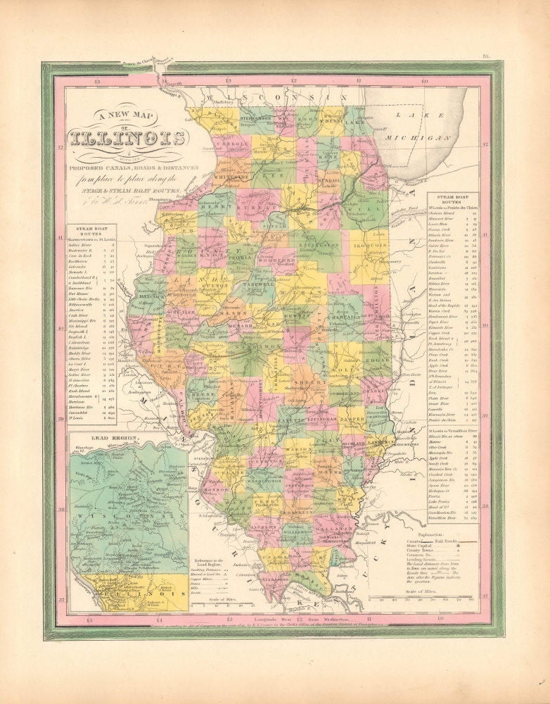

Title
A New Map of Illinois with its Proposed Canals, Roads and Distances from Place to Place along the Stage and Steam Boat Routes.
1846 (dated) 15 x 12 in (38.1 x 30.48 cm) 1 : 2000000
1846 (dated) 15 x 12 in (38.1 x 30.48 cm) 1 : 2000000
Description
This is an uncommon 1846 map of Illinois by S. Augustus Mitchell. It highlights the early 19th-century Lead Boom around Galena.
The bottom left highlights the Illinois lead region, which includes much of southwest Wisconsin, including smelting furnaces, mineral and lead ore deposits, copper mines, mills, and access roads (see below). The Lead Region inset was removed from this map when it was re-engraved in 1850.
The map features the Carey and Hart borders, which were replaced in 1847-48 with new Mitchell borders.
A Closer Look
It covers the state of Illinois, noting canals, railroads, steamboat routes, towns, rivers, roads, and other topographical features. Steamboat routes are listed along the left and right border. The map notes the Illinois and Michigan Canal, then under construction, running from the Illinois River at LaSalle to the Chicago River at Bridgeport, linking the Mississippi River with the Great Lakes. It also notes Illinois' first railroad, the Springfield and Meredosia Railroad, chartered in 1837 and operational from 1841.The bottom left highlights the Illinois lead region, which includes much of southwest Wisconsin, including smelting furnaces, mineral and lead ore deposits, copper mines, mills, and access roads (see below). The Lead Region inset was removed from this map when it was re-engraved in 1850.
The map features the Carey and Hart borders, which were replaced in 1847-48 with new Mitchell borders.
Lead Boom
The early 19th-century lead boom in southwestern Wisconsin and northwestern Illinois was driven by abundant lead deposits in the Upper Mississippi Valley. Beginning in 1823 with the discovery of lead near Galena, large-scale mining operations drew settlers and entrepreneurs seeking to capitalize on the high demand for lead, which was used for bullets, pipes, and industrial applications. Towns like Galena, Illinois, and Mineral Point, Wisconsin, became thriving centers, with Galena briefly rivaling Chicago in economic importance. The boom also drew thousands of European immigrants, especially from Ireland and Germany. By the 1840s, as surface deposits dwindled and easier-to-mine areas were depleted, the region's prominence in lead production declined, giving way to deeper mining operations and other industries.Publication History and Census
This map was published in 1846 in the first edition of Samuel Augustus Mitchell's New Universal Atlas. The map is based on the work of Henry S. Tanner, c. 1836, which Mitchell acquired from Carey and Hart in 1846, who had acquired them from Tanner in 1843. Importantly, in the course of changing hands, the atlas was converted from engraved steel or copper plates to lithographic stones. Mitchell issued the atlas in early 1846 with Tanner's name still on the maps.Cartographer
Samuel Augustus Mitchell (March 20, 1792 - December 20, 1868) began his map publishing career in the early 1830s. Mitchell was born in Bristol, Connecticut. He relocated to Philadelphia in 1821. Having worked as a school teacher and a geographical writer, Mitchell was frustrated with the low quality and inaccuracy of school texts of the period. His first maps were an attempt to rectify this problem. In the next 20 years Mitchell would become the most prominent American map publisher of the mid-19th century. Mitchell worked with prominent engravers J. H. Young, H. S. Tanner, and H. N. Burroughs before attaining the full copyright on his maps in 1847. In 1849 Mitchell either partnered with or sold his plates to Thomas, Cowperthwait and Company who continued to publish the Mitchell's Universal Atlas. By about 1856 most of the Mitchell plates and copyrights were acquired by Charles Desilver who continued to publish the maps, many with modified borders and color schemes, until Mitchell's son, Samuel Augustus Mitchell Junior, entered the picture. In 1859, S.A. Mitchell Jr. purchased most of the plates back from Desilver and introduced his own floral motif border. From 1860 on, he published his own editions of the New General Atlas. The younger Mitchell became as prominent as his father, publishing maps and atlases until 1887, when most of the copyrights were again sold and the Mitchell firm closed its doors for the final time. More by this mapmaker...
Source
Mitchell, S. Augustus, New Universal Atlas Containing Maps of the various Empires, Kingdoms, States and Republics of the World, (Philadelphia: S. Augustus Mitchell) 1846.
The New Universal Atlas is one of the great American atlases of the mid-19th century. Samuel Augustus Mitchell first issued the atlas in 1846 when he acquired the map plates and copyright for Tanner's New Universal Atlas from its publisher, Carey and Hart. The first transitional 1846 edition was published jointly with Carey and Hart, but a second edition was published in the same year with the Tanner imprint erased. This edition of the atlas also introduced the signature S. A. Mitchell green and pink color scheme. Most of the maps from the early editions of the atlas were engraved by H. N. Burroughs or C. S. Williams, often bearing their copyright. Burroughs maps also tended to have what map collector David Rumsey refers to as the 'Cary and Hart' borders, which featured a narrow vine motif. These borders were replaced, along with the Burroughs imprint, with the more traditional Mitchell strap work border used in the atlases until 1856. Mitchell published editions until late in 1850, when he sold the rights to Thomas, Cowperthwait and Company of Philadelphia. Under Cowperthwait, the atlases continued to be published and bear the Mitchell name until 1856, when the plates were again sold, this time to Charles Desilver. Desilver reworked the plates with new border art and a revised color scheme in the style of J. H. Colton. Desilver issued editions from 1857 to 1860, when the atlas was phased out in favor of Samuel Augustus Mitchell Jr.'s New General Atlas.
Condition
Excellent. Slight marginal soiling.
References
Rumsey 0537.032.