1824 Schoolgirl Manuscript Map of Illinois
Illinois-schoolgirl-1824$1,000.00

Title
Illinois.
1824 (undated) 11.5 x 8.5 in (29.21 x 21.59 cm) 1 : 2200000
1824 (undated) 11.5 x 8.5 in (29.21 x 21.59 cm) 1 : 2200000
Description
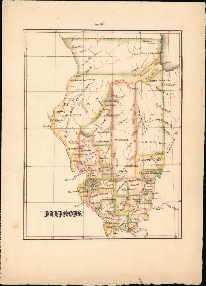
An engrossing example of an early 19th century schoolgirl map, this manuscript work presents 1824 Illinois. It is based on Anthony Finley's map of the state, which demonstrates its rapid territorial evolution in the early years of statehood.
Especially notable are the 'Military Bounty Lands' in the state's northwest, which were set aside for veterans of the War of 1812. Also significant is the early appearance of Chicago along Lake Michigan towards top-right, along with its predecessor Fort Dearborn. The remnant lands of the Ottawa, Winnebago, and the Sac and Fox peoples, including several 'Indian Villages' are also noted.
Though highly reminiscent of Finley's 1824 map of Illinois, not every detail has been retained from the original. For instance, Finley's map displays roads running between the larger towns in the southern part of the state, which are excluded here.
The goals of these exercises were more far-reaching than teaching geography. Girls learned penmanship, each map often using three or more lettering styles. Mapmaking sharpened the retention and recall of factual information. Students were encouraged to take pains in their draftsmanship, and often achieved beautiful flourishes of artistic expression in their maps. But most peculiar to the American iterations of educational mapping was the goal of instilling a sense of civic pride and responsibility. Indeed, the key desired result of the education of girls in the post-Revolutionary-War United States was to prepare for the education of the next generation of American citizens, a patriotic duty which would primarily fall on the shoulders of these young women.
For a good overview of the topic, see Betty Mason's article, '19th Century Schoolgirls Were Incredibly Good at Drawing Maps,' published July 27, 2016 by National Geographic.
A Closer Look
Depicting Illinois, this map displays counties, cities and towns, waterways, hills, and other features. It reflects the state's internal divisions in 1824, only six years after statehood. It was being rapidly settled by migrants from further east and within the state from south to north. As settlers moved northwards, the state capital shifted in tandem. Illinois' first capital, Kaskaskia, can be seen towards bottom-left. By the time this map was produced, it had moved to Vandalia, in the southern part of the tall Fayette County illustrated here. By 1839, the capital moved again to Springfield, in Sangamon County. Within a handful of years, the northern part of the state, including Native American lands, would be parceled out to settlers and formed as new counties.Especially notable are the 'Military Bounty Lands' in the state's northwest, which were set aside for veterans of the War of 1812. Also significant is the early appearance of Chicago along Lake Michigan towards top-right, along with its predecessor Fort Dearborn. The remnant lands of the Ottawa, Winnebago, and the Sac and Fox peoples, including several 'Indian Villages' are also noted.
Though highly reminiscent of Finley's 1824 map of Illinois, not every detail has been retained from the original. For instance, Finley's map displays roads running between the larger towns in the southern part of the state, which are excluded here.
Schoolgirl Maps
While the use of mapmaking in teaching is first seen in Europe, mainly England, the schoolgirl map became a peculiarly American pedagogical tool in the first part of the 19th century, a period in which standards and purposes in women's education were changing. While boys were frequently taught the practical execution of surveys and charts, the production of attractive and informative maps appears to have been primarily the domain of young women. Such maps can be found of the World, the United States, or more specific maps of individual states. These were usually based on generally available reference maps, such as those found in the atlases produced by Carey and Lea, Finley, and Mitchell.The goals of these exercises were more far-reaching than teaching geography. Girls learned penmanship, each map often using three or more lettering styles. Mapmaking sharpened the retention and recall of factual information. Students were encouraged to take pains in their draftsmanship, and often achieved beautiful flourishes of artistic expression in their maps. But most peculiar to the American iterations of educational mapping was the goal of instilling a sense of civic pride and responsibility. Indeed, the key desired result of the education of girls in the post-Revolutionary-War United States was to prepare for the education of the next generation of American citizens, a patriotic duty which would primarily fall on the shoulders of these young women.
For a good overview of the topic, see Betty Mason's article, '19th Century Schoolgirls Were Incredibly Good at Drawing Maps,' published July 27, 2016 by National Geographic.
Publication History and Census
This manuscript map was drawn by an unnamed author and is based on Anthony Finley's map of Illinois that appeared in the 1824 (first) edition of his New General Atlas. As a manuscript map, it is an entirely unique production.Cartographer
Anthony Finley (August 25, 1784 - June 9, 1836) was an American book and map publisher based in Philadelphia, Pennsylvania. Finley was born in Philadelphia in 1784. He opened a bookshop and publishing house at the Northeast corner of Fourth and Chestnut Street, Philadelphia in 1809. His earliest known catalog, listing botanical, medical and other scientific works, appeared in 1811. His first maps, engraved for Daniel Edward Clarke’s Travels in Various Countries of Europe, Asia, and Africa also appear in 1811. His first atlas, the Atlas Classica, was published in 1818. He soon thereafter published the more significant A New American Atlas and the New General Atlas…, both going through several editions from 1824 to 1834. Although most of Finley's cartographic material was borrowed from European sources, his atlases were much admired and favorably reviewed. In addition to his work as a printer, Finley ran unsuccessfully on the 1818 Democratic ticket for Philadelphia Common Council. He was a founding officer of the Philadelphia Apprentices’ Library, and a member of both the American Sunday-School Union and the Franklin Institute. He was also an ardent supporter of the American Colonization Society, an organization dedication to returning free people of color to Africa - which led to the founding of Liberia. Much of his wealth was dedicated to supporting this cause. Finley was active as a publisher until his 1836 death, apparently of a 'lingering illness.' Shortly thereafter advertisements began appearing for his map business and plates, most of which were acquired by Samuel Augustus Mitchell. More by this mapmaker...
Condition
Very good. Manuscript. Minor staining in margins.