This item has been sold, but you can get on the Waitlist to be notified if another example becomes available, or purchase a digital scan.
1891 Rand McNally Map of the United States and the Illinois Central R.R.
IllinoisCentral-randmcnally-1891$175.00

Title
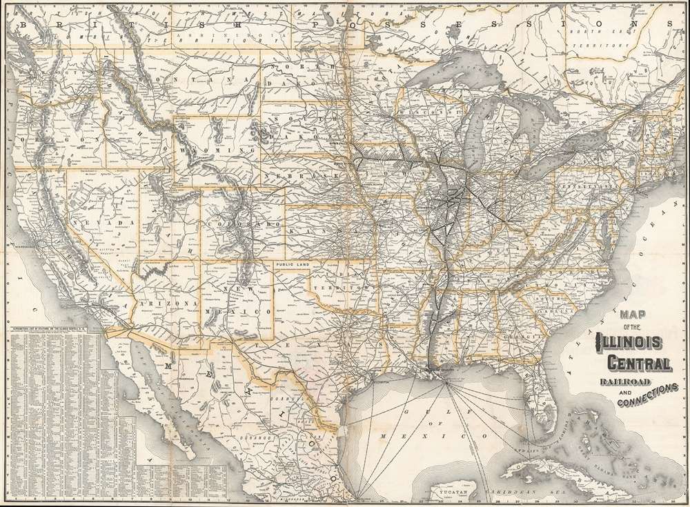
Map of the Illinois Central Railroad and Connections.
1891 (undated) 23.25 x 33.625 in (59.055 x 85.4075 cm) 1 : 6000000
1891 (undated) 23.25 x 33.625 in (59.055 x 85.4075 cm) 1 : 6000000
Description
This is a c. 1891 Rand McNally and Company map of the United States illustrating the Illinois Central Railroad and the rail network throughout the United States. The map depicts the continental United States from the Pacific Ocean to the Atlantic Ocean and from Canada to the Yucatan Peninsula and Cuba. The routes of the Illinois Central are highlighted by bold black lines bisected by white dots, which identify every stop along its lines from Sioux Falls, South Dakota to Cincinnati, Ohio and from Madison, Wisconsin, to New Orleans, Louisiana. Major cities are marked by larger dots, with the largest at Sioux City, Iowa; Chicago, Illinois; St. Louis, Missouri; Cincinnati, Ohio; and Memphis, Tennessee.
The rest of the rail network crossing the United States from coast to coast and winding its way almost everywhere in between branches out from the bolded Illinois Central, as if the entire organization started from its routes. Nearly all the lines are labeled. Major cities and towns throughout the country are identified and state capitals are marked by a special symbol, such as Springfield, Illinois, for example. The country's mountain ranges are illustrated and labeled, as are its major lakes. An alphabetical list of stations on the Illinois Central Railroad is situated in the lower left corner and provides the name of the station and its location on the map's grid.
The rest of the rail network crossing the United States from coast to coast and winding its way almost everywhere in between branches out from the bolded Illinois Central, as if the entire organization started from its routes. Nearly all the lines are labeled. Major cities and towns throughout the country are identified and state capitals are marked by a special symbol, such as Springfield, Illinois, for example. The country's mountain ranges are illustrated and labeled, as are its major lakes. An alphabetical list of stations on the Illinois Central Railroad is situated in the lower left corner and provides the name of the station and its location on the map's grid.
Publication History and Census
This map was created and published by Rand McNally and Company for the Illinois Central Railroad c. 1891. We are aware of no other surviving examples.Cartographer
Rand, McNally and Co. (fl. 1856 - present) is an American publisher of maps, atlases and globes. The company was founded in 1856 when William H. Rand, a native of Quincy, Massachusetts, opened a print shop in Chicago. Rand hired the recent Irish immigrant Andrew McNally to assist in the shop giving him a wage of 9 USD per week. The duo landed several important contracts, including the Tribune's (later renamed the Chicago Tribune) printing operation. In 1872, Rand McNally produced its first map, a railroad guide, using a new cost effective printing technique known as wax process engraving. As Chicago developed as a railway hub, the Rand firm, now incorporated as Rand McNally, began producing a wide array of railroad maps and guides. Over time, the firm expanded into atlases, globes, educational material, and general literature. By embracing the wax engraving process, Rand McNally was able to dominate the map and atlas market, pushing more traditional American lithographic publishers like Colton, Johnson, and Mitchell out of business. Eventually Rand McNally opened an annex office in New York City headed by Caleb S. Hammond, whose name is today synonymous with maps and atlases, and who later started his own map company, C. S. Hammond & Co. Both firms remain in business. More by this mapmaker...
Condition
Good. Backed on archival tissue for stability. Areas of infill at fold intersections. Area of discoloration in top left quadrant. Blank on verso.