This item has been sold, but you can get on the Waitlist to be notified if another example becomes available, or purchase a digital scan.
1872 Beers Map of Cook, Du Page, Kane, Kendall and Will Counties of Illinois
IllinoisCounties-beers-1872$87.50

Title
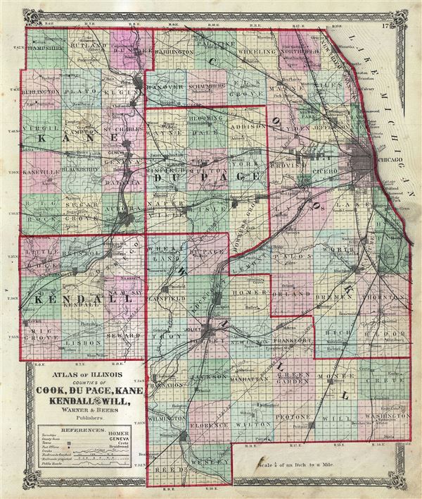
Atlas of Illinois Counties of Cook, Du Page, Kane Kendall and Will.
1872 (undated) 17.5 x 15 in (44.45 x 38.1 cm) 1 : 253440
1872 (undated) 17.5 x 15 in (44.45 x 38.1 cm) 1 : 253440
Description
This is a scarce hand colored map of the counties of Cook, Du Page, Kane, Kendall and Will of the state of Illinois issued by Warner and Beers. Depicts the counties in the northern part of the state of Illinois in great detail, noting towns, finished and projected railroads, public roads, post offices and other topography. The city of Chicago is also depicted. This map was published as plate no. 17 in Warner and Beers Atlas of Whiteside Co. and the State of Illinois.
Cartographer
The Beers family (Fredrick, Silas, James and Daniel) (fl. c. 1850 - 1886), along with Charles and Augustus Warner, were prominent map publishers working from the 1850s to the late 1880s. Often publishing under the Warner & Beers designation, the combined firms produced a series of important state and county atlases and map of much of the northeastern United States. Many of their regional maps are among the most detailed and well laid out maps ever produced of their respective regions. Because Warner & Beers county maps were often detailed down to the individual homes and landowners, they have become highly sought after by general and family historians. In additional to producing maps of surpassing detail, Warner & Beers also maintained an earlier generation's attention to detail and quality while publishing in an era ever increasingly dominated by the low cost printing methods used by the publishing empires of Rand McNally and George Cram. More by this mapmaker...
Source
Warner and Beers, Atlas of Whiteside Co. and the State of Illinois, Chicago, 1872.
Condition
Very good. Overall age toning. Minor spotting here and there. Minor discoloration across map left of center.
References
Rumsey 2585.046. Phillips (Atlases) 1576.