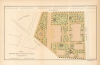
1871 Kellogg and Pilat Map of City Hall Park, New York City
ImprovementsCityHallPark-kellogg-1871-2$350.00


Title
Plan of Improvements of City Hall Park.
1871 (dated) 7 x 11.5 in (17.78 x 29.21 cm) 1 : 1440
1871 (dated) 7 x 11.5 in (17.78 x 29.21 cm) 1 : 1440
Description
A scarce 1871 map of City Hall Park in New York City by Kellogg and Pilat.
This plan also notes the location of the Post Office (demolished 1939), built in 1867 on the southern tip of the park.
City Hall Park
The plan covers City Hall Park, the seat of the city government, located in downtown Manhattan. In the late 17th century, the area was a pasture outside city limits known as the Commons, with a Native American trail running along its western boundary (now Broadway). Several buildings, including an almshouse dating to the late 18th century (archeological evidence of which was unearthed in 1989), a prison, a parade ground, a public execution site, a museum, a post office, and a city hall have been built on this site over the years, with the city hall being the only building remaining to this day.Improving the Park
The park has since been massively redesigned, but some of the elements of this 1871 plan can still be recognized. This plan, by Parks Engineer in Chief M. A. Kellogg and Chief Landscape Gardener I. A. Pilat, illustrates various improvements, including the Mould Fountain. In 1871, the Croton Fountain, built in 1842, was replaced with a new fountain designed by Jacob Wrey Mould. The Mould Fountain was temporarily relocated but returned to City Hall Park in 1999.This plan also notes the location of the Post Office (demolished 1939), built in 1867 on the southern tip of the park.
Publication History and Census
This plan was created by M. A. Kellogg and I. A. Pilat for the First Annual Report of the Board of Commissioners of the Department of Public Parks for the Year Ending May 1, 1871. Specific maps of City Hall Park are scarce, making this a rare find and an interesting addition to any serious collection focusing on New York City.Cartographer
Charles Spangenberg(fl. c. 1862 - 1872) was a topographical draftsman active in the mid to late 19th century. Spangenberg served with the Union Army during the American Civil War (1861 - 1865). His name is attached to at least one important Civil War manuscript maps, of the Battle of Vicksburg, as well as published maps of multiple other battles. After the war, he was active in New York City, where he drew several maps for the New York Parks Commission. More by this mapmaker...
Source
Bryant, William C., First Annual Report of the Board of Commissioners of the Department of Public Parks for the Year Ending May 1, 1871, (New York) 1871.
Condition
Very good. Minor wear along original fold lines. Stabilized on archival tissue.