1780 Bellin Map of India
India-bellin-1780$200.00

Title
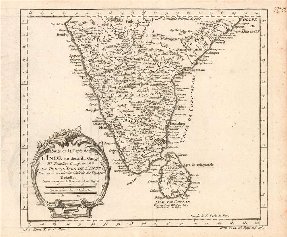
Suite de la carte de l'Inde en deçà du Gange IIe. feuille, comprenant la Presqu' Isle de l'Ind pour servir à l'Histoire générale des voyages.
1780 (undated) 8.5 x 9.5 in (21.59 x 24.13 cm) 1 : 3000000
1780 (undated) 8.5 x 9.5 in (21.59 x 24.13 cm) 1 : 3000000
Description
This is a 1780 Bellin map of India and Sri Lanka. Unlike many of Bellin's smaller works, this is strictly a map, as opposed to a nautical chart: the focus of the map is on the interior, particularly between areas of French influence on the Coromandel Coast such as Pondicheri, and the old Mogul Empire to the northwest.
Source of India's Diamonds
The map shows the fortress city of Golkonda, which was renowned as the world's largest diamond-cutting and diamond-trading center. Although Golconda was not in reality close to diamond mines, it was a key location on a major trade route with actual mines located to the south and east, along the Krishna River. (One such Mine de Diamant is labeled on the map. Until the discovery of diamonds in Brazil, India was the source for most diamonds. These became known as Golconda Diamonds, and in Europe, the word 'Golconda' became a byword for great wealth. Such was the reputation of Indian diamonds that the Portuguese would ship Brazilian diamonds to Goa, in order to export them to Europe as genuine 'Golconda' diamonds.Publication History and Census
This map appears on the market from time to time. Although OCLC only lists copies of the separate map at Princeton, the Universitatsbibliothek LMU Munchen, Bayerische Staatsbibliothek, and the University of Minnesota. Prévost's Histoire and Harpe's abridged version of it are well represented in institutional collections.Cartographer
Jacques-Nicolas Bellin (1703 - March 21, 1772) was one of the most important cartographers of the 18th century. With a career spanning some 50 years, Bellin is best understood as geographe de cabinet and transitional mapmaker spanning the gap between 18th and early-19th century cartographic styles. His long career as Hydrographer and Ingénieur Hydrographe at the French Dépôt des cartes et plans de la Marine resulted in hundreds of high quality nautical charts of practically everywhere in the world. A true child of the Enlightenment Era, Bellin's work focuses on function and accuracy tending in the process to be less decorative than the earlier 17th and 18th century cartographic work. Unlike many of his contemporaries, Bellin was always careful to cite his references and his scholarly corpus consists of over 1400 articles on geography prepared for Diderot's Encyclopedie. Bellin, despite his extraordinary success, may not have enjoyed his work, which is described as "long, unpleasant, and hard." In addition to numerous maps and charts published during his lifetime, many of Bellin's maps were updated (or not) and published posthumously. He was succeeded as Ingénieur Hydrographe by his student, also a prolific and influential cartographer, Rigobert Bonne. More by this mapmaker...
Source
De la Harpe, Abrégé de l'histoire générale des voyages, (Paris), 1780.
Condition
Excellent condition. Full margins.
References
OCLC 830512316.