This item has been sold, but you can get on the Waitlist to be notified if another example becomes available, or purchase a digital scan.
1803 German Manuscript Map of India
India-germanstudent-1803$750.00

Title
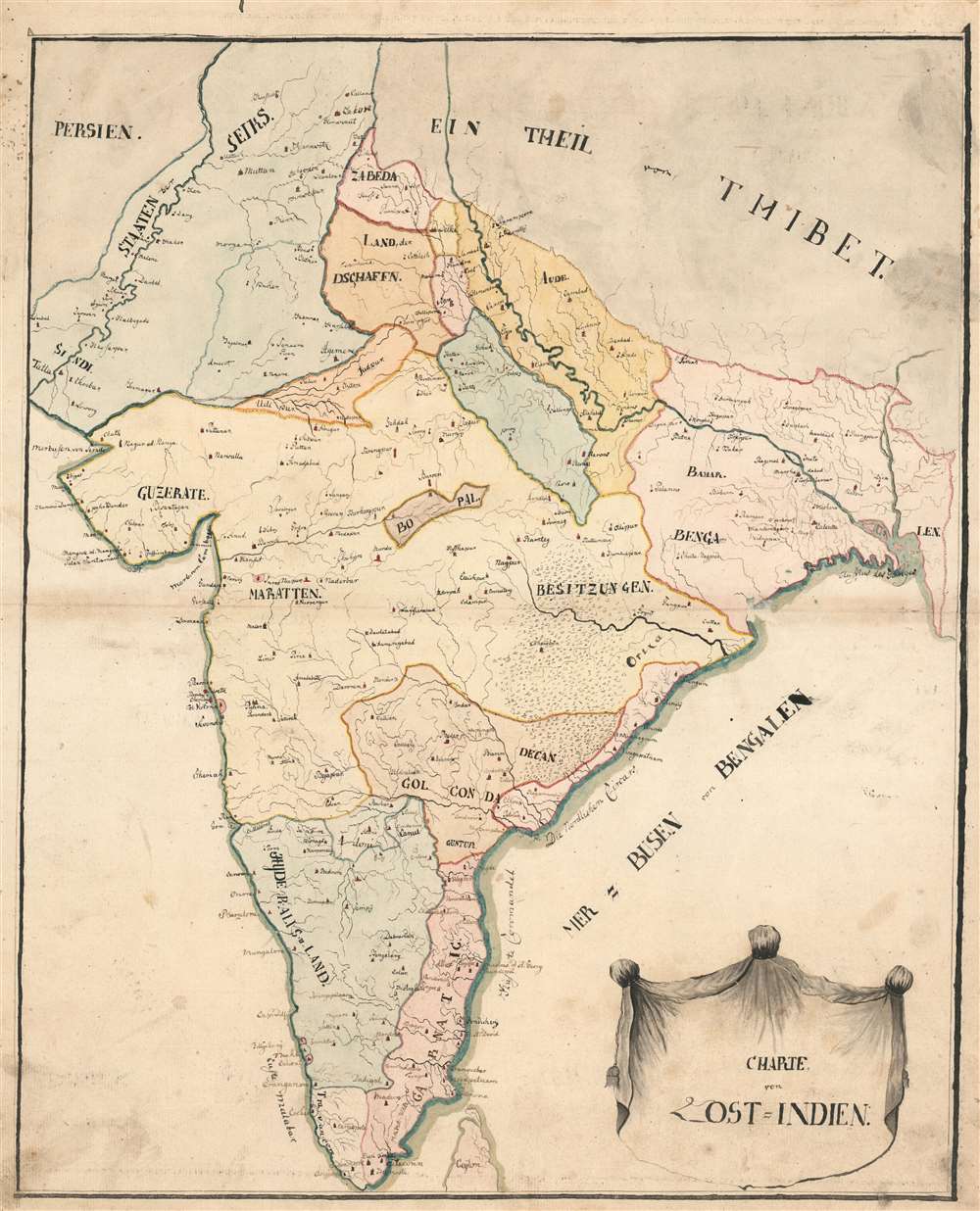
Charte von Ost=Indien.
1803 (undated) 21.5 x 17.5 in (54.61 x 44.45 cm) 1 : 5225000
1803 (undated) 21.5 x 17.5 in (54.61 x 44.45 cm) 1 : 5225000
Description
This remarkable, early 19th century manuscript map of the Indian Peninsula captures the region during the fracture and turmoil of the turn of that century. In particular, it focuses most strongly on two theatres of conflict: those of the Anglo-Maratha Wars (1775 - 1782) in the north, and the Anglo-Mysore Wars (1767 - 1799) in the south, fought between those empires and the British East India Company.
The goals of these exercises were more far-reaching than teaching geography. Girls learned penmanship, each map often using three or more lettering styles. Mapmaking sharpened the retention and recall of factual information. Students were encouraged to take pains in their draftsmanship, and often achieved beautiful flourishes of artistic expression in their maps. But most peculiar to the American iterations of educational mapping was the goal of instilling a sense of civic pride and responsibility. Indeed, the key desired result of the education of girls in the post-Revolutionary-War United States was to prepare for the education of the next generation of American citizens, a patriotic duty which would primarily fall on the shoulders of these young women.
For a good overview, see Betty Mason's '19th Century Schoolgirls Were Incredibly Good at Drawing Maps.' Published July 27, 2016 by National Geographic.
Understanding the Map
The details of this map correspond closely to those found on the 1788 Schräembl/ Rennell Neueste Karte von Hindostan Bengalen etc. etc. but the areas highlighted on the map are consistent with the territorial divisions in place during the course of the Second Maratha War (1803 - 1805). In particular, the region neighboring Bengal in western Orissa is marked 'Besitzungen,' or 'possessions' which would correspond with areas occupied by the British during that war - although the region of Uttar Pradesh south of the Ganges - Bundelkhand, though unnamed on this map - is shown neither as a British territory nor part of the Maratha Empire. The southern part of India reflects the territorial divisions at the close of the Third Anglo-Mysore War (1872), although Mysore is marked 'Hyder Ali's Land' despite the leadership of Mysore having passed to Tipu Sultan, who himself was killed during the Fourth Anglo-Mysore War (1799).Sikh States
The northwestern portion of the map is dominated by the 'Staaten der Seiks,' spanning from the Indus River to absorb Lahore, extending southwards almost to Jodhpur. On the map, the Sikh States abut on the lands of 'Zabeda' (Zabita Khan), a survival from the 1788 Schräembl despite Zabita Khan having been defeated in the 1770s (and dead since 1785.) South of the land of 'Zabeda' is a 'Land Der Dschaffn,' an unfortunate misspelling of 'Dschatten,' which in turn was an unfortunate Germanization of 'Jat,' referring to the traditionally agricultural people who by the 18th century had migrated into the Punjab region, Delhi Territory, northeastern Rajputana, and the western Gangetic Plain. Despite these holdovers from the 1788 map, the dominance in this region of the Sikh States reflects the situation there after 1799.'Schoolgirl' Maps
While the use of mapmaking in teaching most often survives to the market in English and American maps, this early exemplar of the form is from the hand of a German student. As the work is unsigned, we do not know whether this was the work of a boy or a girl. While boys were frequently taught the practical execution of surveys and charts, the production of attractive and informative maps appears to have been primarily the domain of young women in Anglo-American examples. Such maps can be found of the World, England, the United States, or more specific maps of states. These were usually based on generally available reference maps, such as those found in the atlases produced by Carey and Lea, Finley, and Mitchell. As mentioned above, the framework of this map appears to have been based on the 1788 Schräembl edition of the Rennell map of India.The goals of these exercises were more far-reaching than teaching geography. Girls learned penmanship, each map often using three or more lettering styles. Mapmaking sharpened the retention and recall of factual information. Students were encouraged to take pains in their draftsmanship, and often achieved beautiful flourishes of artistic expression in their maps. But most peculiar to the American iterations of educational mapping was the goal of instilling a sense of civic pride and responsibility. Indeed, the key desired result of the education of girls in the post-Revolutionary-War United States was to prepare for the education of the next generation of American citizens, a patriotic duty which would primarily fall on the shoulders of these young women.
For a good overview, see Betty Mason's '19th Century Schoolgirls Were Incredibly Good at Drawing Maps.' Published July 27, 2016 by National Geographic.
Condition
Very good. Some areas of staining; manuscript pen and ink with wash color; overall excellent for this kind.