This item has been sold, but you can get on the Waitlist to be notified if another example becomes available, or purchase a digital scan.
1835 Hall Map of India
India-hall-1835$150.00

Title
Hindoostan.
1835 (undated) 21 x 17 in (53.34 x 43.18 cm) 1 : 6912000
1835 (undated) 21 x 17 in (53.34 x 43.18 cm) 1 : 6912000
Description
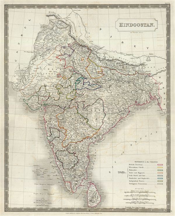
This is a beautiful map of India from Sidney Hall's extremely scarce 1835 New General Atlas. It covers the subcontinent from the Hindoo Khoo (Hindu Kush) Mountain range to Ceylon (Sri Lanka) and from the mouth of the Indus to Birmah (Burma or Myanmar). The modern day countries of India, Sri Lanka, Pakistan, Nepal, Bhutan, Bangladesh and Burma are included. This stunning map offers excellent detail throughout with color coding indicating various political divisions and princely states. Countless important cities including Delhi, Agra, Luknow, Cathmandoo, Goa, Bombay, Calcutta, Colombo, and others are noted. Hall identifies battlegrounds and railway routes. He also notes the elevation several mountains. The region near Gundwana in modern day Chhattisgarh is curiously marked 'unexplored.' A legend in the lower right quadrant lists the reference to the colors identifying the British Territories, Portuguese Possessions, Independent Powers and the various British Allies and Tributaries.
Most of India had, at this juncture, had fallen under the control of the British East India Company. India, long an exporter of manufactured goods, instead became supply house for raw materials to the British Empire. The Empire by this time had also started initiating the non-economic programs for education, culture, and social reform throughout the Subcontinent. Most historians consider this to be the true beginning of India's colonial period. The East India Company ruled India until 1858, after which it was governed by the British Raj until it finally gained independence in 1947.
Sidney Hall's New General Atlas was published from 1830 to 1857, the first edition being the most common, with all subsequent editions appearing only rarely. Most of the maps included in the first edition of this atlas were drawn between 1827 and 1828 and are most likely steel plate engravings, making it among the first cartographic work to employ this technique. Each of the maps in this large and impressive atlas feature elegant engraving and an elaborate keyboard style border. Though this is hardly the first map to employ this type of border, it is possibly the earliest to use it on such a large scale. Both the choice to use steel plate engraving and the addition of the attractive keyboard boarder are evolutions of anti-forgery efforts. Copper plates, which were commonly used for printing bank notes in the early 19th century, proved largely unsuitable due to their overall fragility and the ease with which they could be duplicated. In 1819 the Bank of England introduced a £20,000 prize for anyone who could devise a means to print unforgeable notes. The American inventors Jacob Perkins and Asa Spencer responded to the call. Perkins discovered a process for economically softening and engraving steel plates while Spencer invented an engraving lathe capable of producing complex patters repetitively - such as this keyboard border. Though Perkins and Spenser did not win the prize, their steel plate engraving technique was quickly adopted by map publishers in England, who immediately recognized its value. Among early steel plate cartographic productions, this atlas, published in 1830 by Longman Rees, Orme, Brown & Green stands out as perhaps the finest. This map was issued by Sidney Hall and published by Longman Rees, Orme, Brown & Green of Paternoster Row, London, in the 1835 edition of the Sidney Hall New General Atlas.
Cartographer
Sidney Hall (1788 - 1831) was an English engraver and map publisher active in London during the late 18th and early 19th centuries. His earliest imprints, dating to about 1814, suggest a partnership with Michael Thomson, another prominent English map engraver. Hall engraved for most of the prominent London map publishers of his day, including Aaron Arrowsmith, William Faden, William Harwood, and John Thomson, among others. Hall is credited as being one of the earliest adopters of steel plate engraving, a technique that allowed for finer detail and larger print runs due to the exceptional hardness of the medium. Upon his early death - he was only in his 40s - Hall's business was inherited by his wife, Selina Hall, who continued to publish under the imprint, "S. Hall", presumably for continuity. The business eventually passed to Sidney and Selina's nephew Edward Weller, who became extremely prominent in his own right. More by this mapmaker...
Source
Hall, S., A New General Atlas, with the Divisions and Boundaries, 1835.
Condition
Very good. Original platemark visible. Minor wear along original centerfold. Some offsetting. Blank on verso.
References
Rumsey 4224.028 (1830 edition). Philips (Atlases) 758. Ristow, W., American Maps and Mapmakers: Commercial Cartography in the Nineteenth Century, p. 303-09.