1780 Bellin Map of Northern India, Afghanistan, and Pakistan
IndiaIndoustan-bellin-1780$257.00

Title
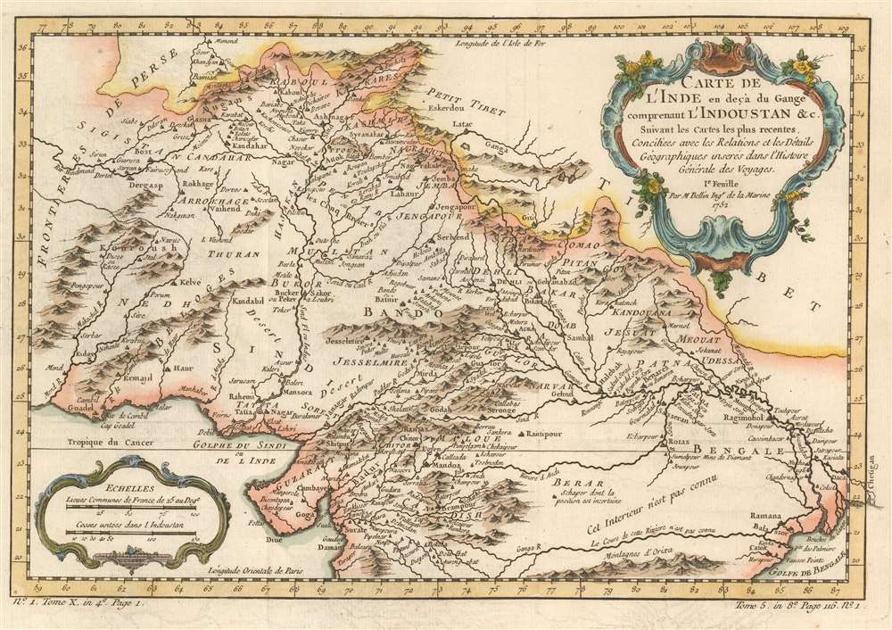
Carte de L'Inde en deçà du Gange comprenant l'Indoustan etc. Suivant les cartes les plus recentes.
1780 (dated) 9.75 x 14 in (24.765 x 35.56 cm) 1 : 9100000
1780 (dated) 9.75 x 14 in (24.765 x 35.56 cm) 1 : 9100000
Description
This is a 1780 Jacques-Nicolas Bellin map of northern India, Afghanistan, and Pakistan. Depicting the region from the Persian frontier to the mouth of the Ganges River, myriad cities, towns, and villages appear on this gorgeously detailed piece, with Kabul, Kandahar, Lahore, and Delhi among them. The area's extensive river system is detailed, and both the Indus and Ganges rivers are labeled. Kashmir, the territory continually in dispute between Pakistan and India today, is also marked.
Publication History and Census
Originally created for of Abbé Prévost's Histoire Générale des Voyages by Jacques-Nicolas Bellin, this map was published by Jean François de La Harpe's in his Abrégé de l'Histoire Générale des Voyages in 1780. Four examples of the 1780 edition of this map are cataloged in OCLC. They are part of the institutional collections at the University of Minnesota Minneapolis, the Universiteitsbibliotheek Leiden in the Netherlands, Universitätsbibliothek München in Munich, and Bayerische Staatsbibliothek, also in Munich. The works by Prévost and de la Harpe are well represented institutionally.Cartographer
Jacques-Nicolas Bellin (1703 - March 21, 1772) was one of the most important cartographers of the 18th century. With a career spanning some 50 years, Bellin is best understood as geographe de cabinet and transitional mapmaker spanning the gap between 18th and early-19th century cartographic styles. His long career as Hydrographer and Ingénieur Hydrographe at the French Dépôt des cartes et plans de la Marine resulted in hundreds of high quality nautical charts of practically everywhere in the world. A true child of the Enlightenment Era, Bellin's work focuses on function and accuracy tending in the process to be less decorative than the earlier 17th and 18th century cartographic work. Unlike many of his contemporaries, Bellin was always careful to cite his references and his scholarly corpus consists of over 1400 articles on geography prepared for Diderot's Encyclopedie. Bellin, despite his extraordinary success, may not have enjoyed his work, which is described as "long, unpleasant, and hard." In addition to numerous maps and charts published during his lifetime, many of Bellin's maps were updated (or not) and published posthumously. He was succeeded as Ingénieur Hydrographe by his student, also a prolific and influential cartographer, Rigobert Bonne. More by this mapmaker...
Source
De la Harpe, Abrégé de l'histoire générale des voyages. (Paris) 1780.
Condition
Very good. Exhibits light offsetting.
References
OCLC 163339581.