This item has been sold, but you can get on the Waitlist to be notified if another example becomes available, or purchase a digital scan.
1895 Rand McNally Map of China, Southeast Asia, and the Philippines
IndochinaMalay-randmcnally-1895$50.00

Title
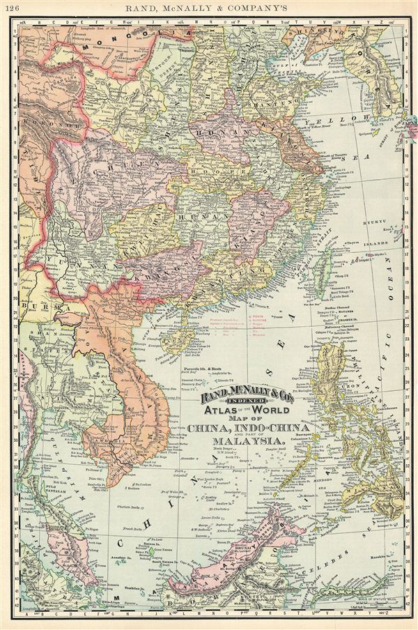
Map of China, Indo-China and part of Malaysia.
1895 (undated) 21 x 13.5 in (53.34 x 34.29 cm) 1 : 9500000
1895 (undated) 21 x 13.5 in (53.34 x 34.29 cm) 1 : 9500000
Description
This is a beautiful example of Rand McNally and Company's 1895 map of China, Southeast Asia, and the Philippines. It covers from Korea south as far as Borneo and from Burma to the western tip of Japan. The Malay Archipelago (or east Indies) is here referred to as Malaysia, not to be confused with the modern day country of Malaysia on the Malay Peninsula, which is included here, but not named. Both the Great Wall and the Grand Canal in China are identified. Taiwan or Formosa is mapped vaguely, representing the poor knowledge of the region prior to the Japanese invasion and subsequent survey work in 1895. As this map was drawn, Imperial China wilted under the weak Qing Dynasty while in 1893, the Franco-Siamese War was about to break out between the Kingdom of Siam and the French Republic. This would ultimately result in the secession of Laos to the French. Color coded according to provinces and regions, the map notes several towns, cities, rivers, mountains and various other topographical details with relief shown by hachure. This map was issued as plate no. 529 in the 1895 issue of Rand McNally and Company's Indexed Atlas of the World - possibly the finest atlas Rand McNally ever issued.
Cartographer
Rand, McNally and Co. (fl. 1856 - present) is an American publisher of maps, atlases and globes. The company was founded in 1856 when William H. Rand, a native of Quincy, Massachusetts, opened a print shop in Chicago. Rand hired the recent Irish immigrant Andrew McNally to assist in the shop giving him a wage of 9 USD per week. The duo landed several important contracts, including the Tribune's (later renamed the Chicago Tribune) printing operation. In 1872, Rand McNally produced its first map, a railroad guide, using a new cost effective printing technique known as wax process engraving. As Chicago developed as a railway hub, the Rand firm, now incorporated as Rand McNally, began producing a wide array of railroad maps and guides. Over time, the firm expanded into atlases, globes, educational material, and general literature. By embracing the wax engraving process, Rand McNally was able to dominate the map and atlas market, pushing more traditional American lithographic publishers like Colton, Johnson, and Mitchell out of business. Eventually Rand McNally opened an annex office in New York City headed by Caleb S. Hammond, whose name is today synonymous with maps and atlases, and who later started his own map company, C. S. Hammond & Co. Both firms remain in business. More by this mapmaker...
Source
Rand McNally & Co., Foreign Countries. Rand, McNally & Co's Indexed Atlas of the World (Complete in Two Volumes)…, (Chicago) 1895.
Condition
Very good. Text on verso.
References
Rumsey 3565.033 (1897 edition). Philip (atlases) 1026 (1898 edition).