This item has been sold, but you can get on the Waitlist to be notified if another example becomes available, or purchase a digital scan.
1849 Mitchell Map of Iowa
Iowa2-mitchell-1849$125.00

Title
Iowa.
1849 (undated) 16.5 x 13.5 in (41.91 x 34.29 cm) 1 : 1400000
1849 (undated) 16.5 x 13.5 in (41.91 x 34.29 cm) 1 : 1400000
Description
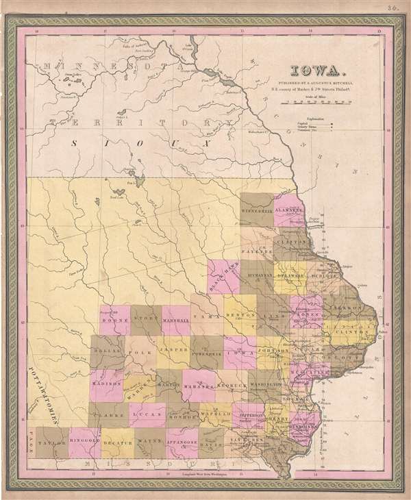
This is a Samuel Augustus Mitchell’s 1849 map of Iowa. The map covers the eastern parts of modern day Iowa with county platting limited to the southeastern quadrants. The remainder of the state depicted is devoted to American Indian Nations. The map identifies towns, rivers, roads and other topographical features.
Iowa was admitted to the Union on December 28 of 1846 and around the same time the Sac and Fox largely withdrew from Iowa - a legacy of the 1832 Black Hawk War. The Sioux meanwhile ranged far and wide in northern Iowa, including deep into Sac and Fox territory. The U.S. Government subsequently established a Neutral Ground roughly 40 miles wide and enforced from Fort Atkinson, as a buffer zone between the two tribes. That regions is shown here as two parallel lines extending across the map from the Mississippi to the Lizard River.
The whole is engraved and colored in Mitchell's distinctive style with green border work and vivid pastels. This map was issued in the 1849 edition of the S. A. Mitchell's New Universal Atlas. This was the last edition of that atlas to be published by Mitchell prior to selling the plates and rights to Thomas Cowperthwait late in 1850.
Cartographer
Samuel Augustus Mitchell (March 20, 1792 - December 20, 1868) began his map publishing career in the early 1830s. Mitchell was born in Bristol, Connecticut. He relocated to Philadelphia in 1821. Having worked as a school teacher and a geographical writer, Mitchell was frustrated with the low quality and inaccuracy of school texts of the period. His first maps were an attempt to rectify this problem. In the next 20 years Mitchell would become the most prominent American map publisher of the mid-19th century. Mitchell worked with prominent engravers J. H. Young, H. S. Tanner, and H. N. Burroughs before attaining the full copyright on his maps in 1847. In 1849 Mitchell either partnered with or sold his plates to Thomas, Cowperthwait and Company who continued to publish the Mitchell's Universal Atlas. By about 1856 most of the Mitchell plates and copyrights were acquired by Charles Desilver who continued to publish the maps, many with modified borders and color schemes, until Mitchell's son, Samuel Augustus Mitchell Junior, entered the picture. In 1859, S.A. Mitchell Jr. purchased most of the plates back from Desilver and introduced his own floral motif border. From 1860 on, he published his own editions of the New General Atlas. The younger Mitchell became as prominent as his father, publishing maps and atlases until 1887, when most of the copyrights were again sold and the Mitchell firm closed its doors for the final time. More by this mapmaker...
Source
Mitchell, S. A., A New Universal Atlas, (S. A. Mitchell; Philadelphia) 1849.
The New Universal Atlas is one of the great American atlases of the mid-19th century. Samuel Augustus Mitchell first issued the atlas in 1846 when he acquired the map plates and copyright for Tanner's New Universal Atlas from its publisher, Carey and Hart. The first transitional 1846 edition was published jointly with Carey and Hart, but a second edition was published in the same year with the Tanner imprint erased. This edition of the atlas also introduced the signature S. A. Mitchell green and pink color scheme. Most of the maps from the early editions of the atlas were engraved by H. N. Burroughs or C. S. Williams, often bearing their copyright. Burroughs maps also tended to have what map collector David Rumsey refers to as the 'Cary and Hart' borders, which featured a narrow vine motif. These borders were replaced, along with the Burroughs imprint, with the more traditional Mitchell strap work border used in the atlases until 1856. Mitchell published editions until late in 1850, when he sold the rights to Thomas, Cowperthwait and Company of Philadelphia. Under Cowperthwait, the atlases continued to be published and bear the Mitchell name until 1856, when the plates were again sold, this time to Charles Desilver. Desilver reworked the plates with new border art and a revised color scheme in the style of J. H. Colton. Desilver issued editions from 1857 to 1860, when the atlas was phased out in favor of Samuel Augustus Mitchell Jr.'s New General Atlas.
Condition
Very good. Left margin narow, as issued.
References
Rumsey 0545.038.