1845 General Land Office Map of the Iowa Territory
IowaTerritory-landoffice-1845$200.00

Title
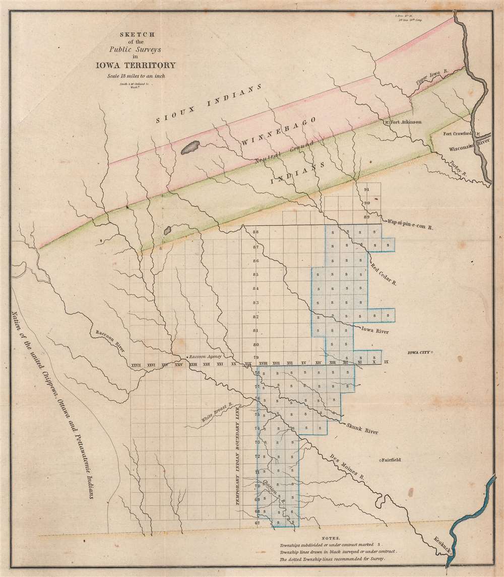
Sketch of the Public Surveys in Iowa Territory.
1845 (undated) 13.375 x 11.75 in (33.9725 x 29.845 cm) 1 : 1140480
1845 (undated) 13.375 x 11.75 in (33.9725 x 29.845 cm) 1 : 1140480
Description
This is an 1845 General Land Office map of the Iowa Territory, covering lands west of the Wisconsin River. The 'Neutral Ground' separating the warring Sioux and Sac and Fox Indian nations dominates the upper map. Fort Atkinson, established to protect the forcibly resettled Winnebago, is labeled within the 'Neutral Ground'. Townships appear below the 'Neutral Ground', and the settlements of Iowa City, Fairfield, and Keokuck are labeled.
This did not last. Minerals were discovered in modern-day southern Wisconsin in what was then Winnebago land. When miners began encroaching, the Winnebago removed them and defended their lands. Hoping to avoid further conflicted, the Federal government negotiated the cession of the Winnebago lands. The Winnebago were forcibly relocated to the 'Neutral Ground'.
While this idea likely appeared sound to the government officials to organized it, the move failed to take into account the Winnebago themselves. The Winnebago had little desire to move across the Mississippi. Further, reassigning the 'Neutral Ground' placed the Winnebago between two more powerful, antagonistic nations, the Sioux and the Sac and Fox. The Sac and Fox in particular held lingering animosity toward the Winnebago from the Black Hawk War (April 6, 1832 - August 27, 1832). Fort Atkinson was established on the Turkey River to protect the Winnebago, a daunting two-regiment force that kept the tenuous peace from 1843 to 1849, when the Winnebago were again relocated, this time to Minnesota.
Neutral Ground
Two strips of land stretching from the Mississippi River to the upper Des Moines River (labeled here as Raccoon River) illustrate what was known as the 'Neutral Ground'. In 1830, the U.S. government decided to intervene in a war between the Sioux and the Sac and Fox. The forced peace treaty stipulated that both tribes cede a strip of land twenty miles wide extending from the Mississippi River to the Des Moines River to the U.S. government. This area was intended as a 'buffer zone' to reduce future conflict. The agreement worked well, with both tribes peacefully using the 'Neutral Ground' as hunting ground.This did not last. Minerals were discovered in modern-day southern Wisconsin in what was then Winnebago land. When miners began encroaching, the Winnebago removed them and defended their lands. Hoping to avoid further conflicted, the Federal government negotiated the cession of the Winnebago lands. The Winnebago were forcibly relocated to the 'Neutral Ground'.
While this idea likely appeared sound to the government officials to organized it, the move failed to take into account the Winnebago themselves. The Winnebago had little desire to move across the Mississippi. Further, reassigning the 'Neutral Ground' placed the Winnebago between two more powerful, antagonistic nations, the Sioux and the Sac and Fox. The Sac and Fox in particular held lingering animosity toward the Winnebago from the Black Hawk War (April 6, 1832 - August 27, 1832). Fort Atkinson was established on the Turkey River to protect the Winnebago, a daunting two-regiment force that kept the tenuous peace from 1843 to 1849, when the Winnebago were again relocated, this time to Minnesota.
Townships
Townships are platted below the 'Neutral Ground' west of Iowa City. Some townships are marked with an 'S', indicating that they have been subdivided and sold. Those marked by solid black lines and no 'S' were surveyed or under contract. Townships marked by dotted lines were recommended to be surveyed.A Short Explanation of a Township
The township was created as the measure of the Public Land Survey System, which was first widely implemented to survey the Northwest Ordinance. The Public Land Survey System allowed for the systematic surveying and mapping of any territory gained by the United States. It played a pivotal role in subsequent settlement and administration new territories and states. The work of the survey influenced American Indian removal efforts, town building, railroad grants, new settlement, and more. Moreover, the efforts of the Federal Land Survey were significant in centralizing power with the Federal Government at the expense of states.Publication History and Census
This map was created for and published by the General Land Office for a report to the United States Congress in 1845. We note eleven examples of the separate map cataloged in OCLC, including at Yale University, Harvard University, the University of Illinois at Urbana Champaign, the University of Iowa, Iowa State University, and the University of Oregon.Cartographer
The General Land Office (GLO) (1812 - 1946) was an independent agency of the United States government responsible for public domain lands in the United States. Created in 1812, it took over functions previously conducted by the Department of the Treasury. The GLO oversaw the surveying, platting, and sale of public lands in the western United States. It also administered the Preemption Act of 1841, which allowed individuals who were already living on federal land to purchase up to 160 acres of land before it was offered for sale to the general public, if they met certain requirements. Following the passage of the Homestead Act in 1862, which was also administered by the GLO, claims under the Preemption Act sharply decreased. The GLO became a part of the newly-created Department of the Interior in 1849. In 1891 Grover Cleveland and Congress created 17 forest reserves, due to public concern over forest conservation, which were initially managed by the GLO, until they were transferred to the Forest Service in 1905. In 1946 the Government Land Office was merged with the United States Grazing Service to become the Bureau of Land Management. Today the Bureau of Land Management administers the roughly 246 million acres of public land remaining under federal ownership. More by this mapmaker...
Condition
Very good. Light wear along original fold lines. Light foxing. Two printer's creases evident.
References
OCLC 24001053.