1849 / 1857 Jones Map of Ancient Canals near Baghdad, Iraq
IraqAncientCanals-jones-1857$950.00

Title
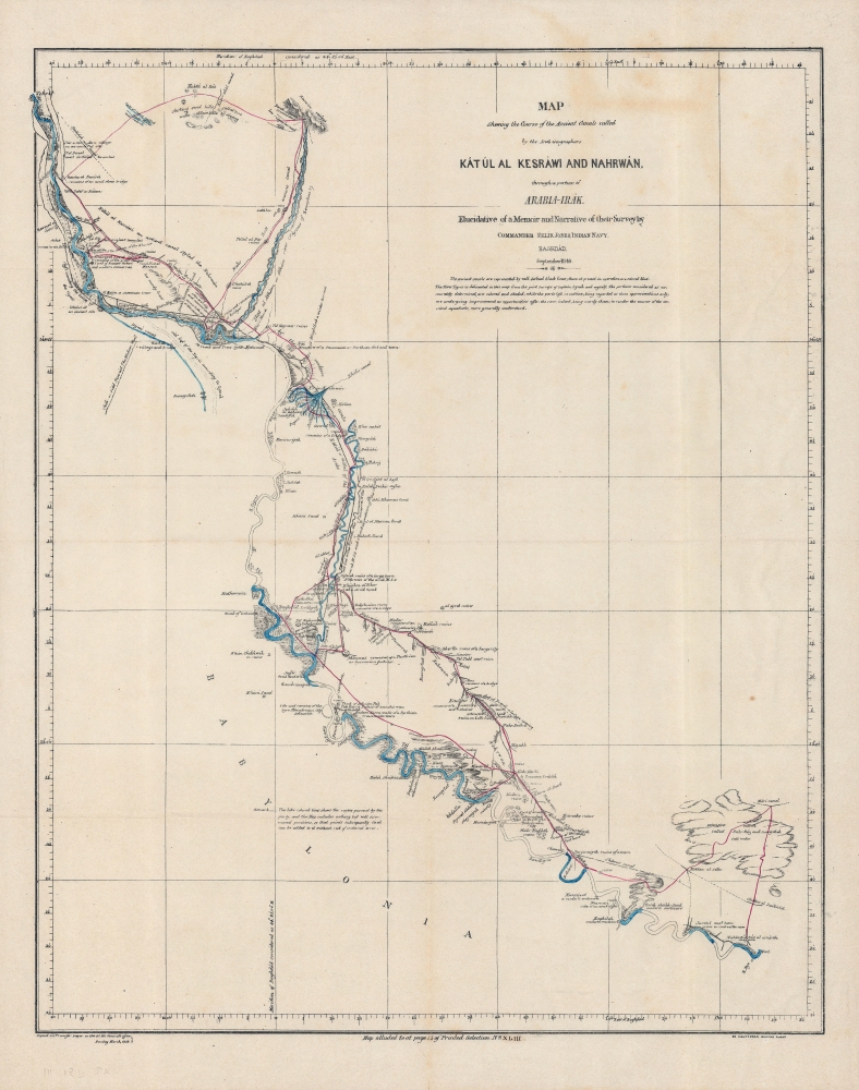
Map shewing the course of the ancient canals called by the Arab geographers Kátúl al Kesráwi and Nahrwán through a portion of Arabia-Irak : elucidative of a memoir and narrative of their survey by Commander Felix Jones, Indian Navy, Baghdad, September 1849.
1857 (dated) 22 x 17.5 in (55.88 x 44.45 cm) 1 : 490000
1857 (dated) 22 x 17.5 in (55.88 x 44.45 cm) 1 : 490000
Description
A rare 1849 map of the region around Baghdad that appeared in James Felix Jones' Memoirs (published 1857), one of the most important English-language sources on Ottoman Iraq. Jones highlights the ancient Nahrawan Canal system on the Tigris and Diyala Rivers, which was the main source of water for the region in the Sassanid (3-7th century CE) and early Islamic eras.
This initial construction of the city was badly damaged in the early 9th century CE in a conflict between brothers vying for the title of caliph. A century later, the canal system was deliberately breached in a failed bid to suppress a revolt against Muhammad ibn Ra'iq, a regent for the caliphate. This event caused extensive flooding in the region, ruining its agricultural productivity, and became a notorious act which signaled a steep decline in Abbasid power. Though Baghdad rebounded and subsequent rulers occasionally attempted to revive the canals, they mostly remained a dry riverbed, including through late Ottoman times, when Jones explored them.
A Closer Look
Ranging from Tikrit in the north, past Baghdad at center towards left, and southwards toward Kut, this map focuses on the Tigris River, some of its tributaries (especially the Diyala), and ancient canals that were built to provide the region with water. Throughout, ancient settlement sites, tombs, fortresses, bridges, and ruins are noted in detail. The portions of river traversed by Jones are shaded blue, while the ancient canals referred to in the title, collectively referred to simply as the Nahrawan Canal, are drawn in purple.Early Islamic Baghdad and the Nahrawan Canal
Though dating as early as the 3rd century CE, the canal system seen here is remembered for providing Baghdad with water as it grew into a renowned metropolis of learning and culture in the Abbasid period. Replacing Ctesiphon-Seleucia to the southeast along the Tigris (labeled here), Baghdad was founded in 762 CE (144 AH) as the capital of the Abbasid Caliphate. It was a planned city, known in its first manifestation as the 'round city,' and required thousands of architects, surveyors, and laborers to construct.This initial construction of the city was badly damaged in the early 9th century CE in a conflict between brothers vying for the title of caliph. A century later, the canal system was deliberately breached in a failed bid to suppress a revolt against Muhammad ibn Ra'iq, a regent for the caliphate. This event caused extensive flooding in the region, ruining its agricultural productivity, and became a notorious act which signaled a steep decline in Abbasid power. Though Baghdad rebounded and subsequent rulers occasionally attempted to revive the canals, they mostly remained a dry riverbed, including through late Ottoman times, when Jones explored them.
Publication History and Census
This map was drawn in 1849 and appeared in Jones' Memoirs by Commander James Felix Jones, I.N. Steam-Trip to the North of Baghdad, in April 1846…, published in 1857 in Bombay (Mumbai). Jones and his collaborators travelled extensively throughout Baghdad and its surrounding region, gaining greater access than other Western travelers of the era. As a result, Jones' memoirs became a major source of information about Ottoman Iraq and Baghdad in particular. This map is quite rare, being independently cataloged with the University of Oxford and the Zentralbibliothek Zürich, and having no known history on the market, while Jones' entire memoir is held by perhaps twenty-five institutions worldwide.Cartographer
James Felix Jones (September 5, 1813 - September 3, 1878) was British officer of the East India Company and the Indian Navy. He served as surveyor, and amateur archeologist active in the Middle East in the mid-19th century. He was born in Shoreditch, London, England. He joined the Bombay Marine at 14, where an aptitude at mathematics led him to be taught surveying. He became involved in various British survey projects throughout the Middle East. As a midshipman on the RIMS Palinurus, he completed a series of surveys of the Red Sea littoral. By the 1820s, he was reassigned to the Persian Gulf, where he worked on the first British survey of those waters. In 1839, he surveyed Kuwait harbor. In addition to his military surveys, he accompanied Henry Creswicke Rawlinson on an overland journey from Baghdad to Hamadān, along the way producing a series of seminal archeological surveys of the ruins of antiquity. These included including the course of the ancient Nahrwan Canal (1848), the course of the Tigris and what he believed to be the site of Opis (1850), the Assyrian heartland (1852), Nimrud and Nineveh (1852), and the Baghdad area (1853). With years of Middle East experience behind him, Jones was assigned the position of Political Agent in the Persian Gulf. It has been argued that, in this capacity, he played a role in the British invasion of Persia (1856 - 1857). He retired from active service in 1862, suffering ill health and returning to London. He settled in Upper Norwood, Surrey, where he nonetheless continued to produce geographical work for the India Office. In 1875, he completed a beautifully drawn map of western Asia, including the valleys of the Tigris and Euphrates, which survives in manuscript but remains unpublished. Jones' 1878 Geographical Magazine obituary called him 'one of the greatest ornaments of the old Indian Navy'. More by this mapmaker...
Source
Jones, J. F. (R. Hughes Thomas, comp.), Memoirs by Commander James Felix Jones I.N: steam-trip to the North of Baghdad in April 1846 with notes on various objects of interest en route..., (Bombay: Bombay Education Society's Press) 1857.
Condition
Very good. Verso repairs to fold separations. Closed margin tears professionally repaired on verso.
References
OCLC 941071204, 1283582901.