This item has been sold, but you can get on the Waitlist to be notified if another example becomes available, or purchase a digital scan.
1747 Bowen Map of Ireland
Ireland-bowen-1747$150.00

Title
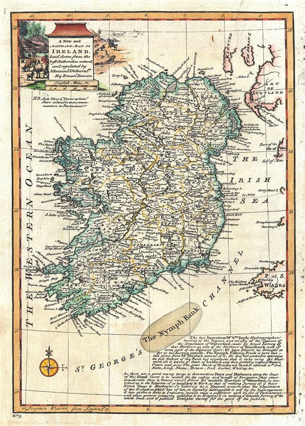
A New and Accurate Map of Ireland.
1747 (undated) 13.5 x 9.5 in (34.29 x 24.13 cm) 1 : 2300000
1747 (undated) 13.5 x 9.5 in (34.29 x 24.13 cm) 1 : 2300000
Description
This is an appealing 1747 map of Ireland by the British cartographer Emanuel Bowen. The map covers all of Ireland, noting important towns, cities bays, harbors, roads, etc. Forests, mountains are rendered pictorially. The lower right quadrant of the map includes notes about the bays and harbors along the coast of Ireland, and about the Nymph Bank according to Mr. William Doyle's accounts. A beautifully illustrated title cartouche in the upper left quadrant depicts scenes of hunting and cattle grazing. This map was prepares by Emanuel Bowen as plate no. 9 for the 1747 issue of A Complete System of Geography.
Cartographer
Emanuel Bowen (1694 - May 8, 1767) had the high distinction to be named Royal Mapmaker to both to King George II of England and Louis XV of France. Bowen was born in Talley, Carmarthen, Wales, to a distinguished but not noble family. He apprenticed to Charles Price, Merchant Taylor, from 1709. He was admitted to the Merchant Taylors Livery Company on October 3, 1716, but had been active in London from about 1714. A early as 1726 he was noted as one of the leading London engravers. Bowen is highly regarded for producing some of the largest, most detailed, most accurate and most attractive maps of his era. He is known to have worked with most British cartographic figures of the period including Herman Moll and John Owen. Among his multiple apprentices, the most notable were Thomas Kitchin, Thomas Jeffreys, and John Lodge. Another apprentice, John Oakman (1748 - 1793) who had an affair with and eventually married, Bowen's daughter. Other Bowen apprentices include Thomas Buss, John Pryer, Samuel Lyne, his son Thomas Bowen, and William Fowler. Despite achieving peer respect, renown, and royal patronage, Bowen, like many cartographers, died in poverty. Upon Emanuel Bowen's death, his cartographic work was taken over by his son, Thomas Bowen (1733 - 1790) who also died in poverty. More by this mapmaker...
Source
Bowen, E., A complete system of geography. Being a description of all the countries, islands, cities, chief towns, harbours, lakes, and rivers, mountains, mines, etc., of the known world …, (London) 1747.
Condition
Very good. Original platemark visible. Minor wear and verso repair over top border, extending up to an inch over printed area. Verso repair on bottom and right border, not extending onto printed area.
References
Rumsey 3733.008. Philips (atlases) 614 (1752 edition).