This item has been sold, but you can get on the Waitlist to be notified if another example becomes available.
1838 S. D. U. K. Map of Ireland
Ireland-sduk-1838$100.00

Title
Ireland
1838 (dated) 23.5 x 19 in (59.69 x 48.26 cm) 1 : 785000
1838 (dated) 23.5 x 19 in (59.69 x 48.26 cm) 1 : 785000
Description
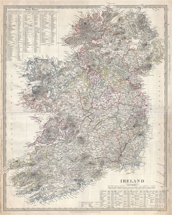
This is an appealing 1838 Map of Ireland issued by the Society for the Diffusion of Useful Knowledge, or S.D.U.K. It depicts the entire Emerald divided into 32 counties. It covers from Donegal in the north to Cork in the south. Towns, rivers, mountains, railroads, roads and various other important topographical details are noted. Elevation throughout is rendered by hachure and political and territorial boundaries are outlined in color. It also names the four ancient provinces of Leister, Ulster, Munster, and Connaught. A statistic table for the four provinces is included in the lower right quadrant of the map, while the upper left quadrant features a list of the 'round towers.' Tuscar Rock near the southeast coast of Ireland, known to have destroyed more ships than any other Irish coastal feature, is identified.
After the Norman Invasion the old provincial structure was supplemented with modern system of counties - even so the old provinces are still referenced today. In 1801, the island of Ireland became part of the United Kingdom of Great Britain and Ireland. Though Britain flourished during the 19th century, Ireland suffered a series of famines, the worst being the Great Irish Famine, which lasted from 1845 - 1849 and killed about a million people. As a result Ireland experienced a widespread exodus - mostly to the United States. By the end of the 19th century, almost 50% of immigrants into the United States hailed from Ireland.
This map was engraved by J. and C. Walker and published under the superintendence of the Society for the Diffusion of Useful Knowledge, or S.D.U.K. Although the Society formally closed its doors in 1848, subsequent reissues of the S.D.U.K. atlas were printed well into the 1870s by Chapman and Hall, who acquired the original plates.
Cartographer
The "Society for the Diffusion of Useful Knowledge" (1826 - 1848) was a Whiggish organization founded in 1828 at the instigation of idealistic British lord Henry Peter Brougham. The admirable goal of the Society was to distribute useful information via a series of publications to the English working and middle classes. It promoted self-education and the egalitarian sharing of all knowledge. While closely tied to the London University and publishing houses on the order of Baldwin and Cradock, Chapman and Hall, and Charles Knight, the Society failed to achieve its many lofty goals in finally closed its doors in 1848. Most likely the failure of the Society resulted from its publications being too expensive for its intended lower to middle class markets and yet not large and fine enough to appeal to the aristocratic market. Nonetheless, it did manage to publish several extraordinary atlases of impressive detail and sophistication. Their most prominent atlas consisted of some 200 separately issued maps initially published by Baldwin and Cradock and sold by subscription from 1829 to 1844. Afterwards, the Society combined the maps into a single world atlas published under the Chapman and Hall imprint. In its day, this atlas was unprecedented in its quality, scope, and cost effectiveness. Today Society, or S.D.U.K. as it is commonly known, maps are among the most impressive examples of mid-19th century English mass market cartographic publishing available. The S.D.U.K. is especially known for its beautiful and accurately detailed city plans. More by this mapmaker...
Source
Maps of the Society for the Diffusion of Useful Knowledge, Vol. 1, (London: Chapman and Hall) 1844.
Condition
Very good. Minor wear and verso repair along original fold lines. Paper exhibits slight warping. Minor foxing along margins.
References
Rumsey 0890.026, 0890.027. Philips (Atlases) 794.