This item has been sold, but you can get on the Waitlist to be notified if another example becomes available, or purchase a digital scan.
1853 Wyld Pocket or Case Map of Ireland
Ireland-wyld-1853$375.00

Title
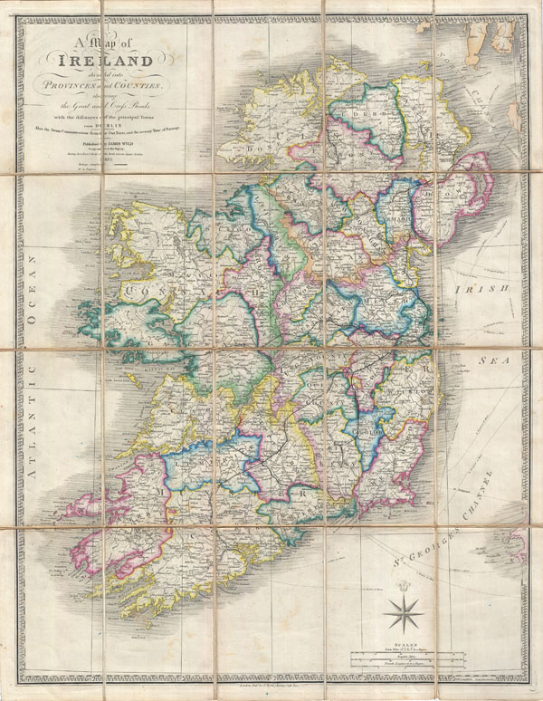
A Map of Ireland divided into Provinces and Counties shewing the Great and Cross Roads with distances of the principal Towns from Dublin. Also the Steam Communications from the Out Ports, and the average Time of Passage.
1853 (dated) 29 x 23 in (73.66 x 58.42 cm)
1853 (dated) 29 x 23 in (73.66 x 58.42 cm)
Description
A stunning example of James Wyld's 1853 case map of Ireland. Covers the entirety of Ireland as well as the major nautical and ferry routes between Ireland, England and Scotland. Divided and color coded into provinces and counties. Offers extraordinary detail throughout, identifying all major towns, rail lines, post roads, rivers, canals, and some undersea formations. Cartographically this map is based upon William Faden's map of 1798, the plates for which Wyld acquired upon Faden's death in 1836. Wyld updated the original plate with new cartographic information and a more contemporary keyboard style border. This particular example was prepared as a pocket or case map, being dissected and mounted on linen for easy folding. Comes with original binder which suggests that the may must have been originally acquired by a library Perth, Australia before being deaccessioned and finding its way to us.
Cartographer
Wyld (1823 - 1893) was a British publishing firm active throughout the 19th century. It was operated by James Wyld I (1790 - 1836) and his son James Wyld II (November 20, 1812 - 1887) were the principles of an English mapmaking dynasty active in London during much of the 19th century. The elder Wyld was a map publisher under William Faden (1749 - 1836) and did considerable work on the Ordinance Survey. On Faden's retirement in 1823, Wyld took over Faden's workshop, acquiring many of his plates. Wyld's work can often be distinguished from his son's maps through his imprint, which he signed as 'Successor to Faden'. Following in his father's footsteps, the younger Wyld joined the Royal Geographical Society in 1830 at the tender age of 18. When his father died in 1836, James Wyld II was prepared to fully take over and expand his father's considerable cartographic enterprise. Like his father and Faden, Wyld II held the title of official Geographer to the Crown, in this case, Queen Victoria. In 1852, he moved operations from William Faden's old office at Charing Cross East (1837 - 1852) to a new, larger space at 475 Strand. Wyld II also chose to remove Faden's name from all of his updated map plates. Wyld II continued to update and republish both his father's work and the work of William Faden well into the late 1880s. One of Wyld's most eccentric and notable achievements is his 1851 construction of a globe 19 meters (60 feet) in diameter in the heart of Leicester Square, London. In the 1840s, Wyld also embarked upon a political career, being elected to parliament in 1847 and again in 1857. He died in 1887 following a prolific and distinguished career. After Wyld II's death, the family business was briefly taken over by James John Cooper Wyld (1844 - 1907), his son, who ran it from 1887 to 1893 before selling the business to Edward Stanford. All three Wylds are notable for producing, in addition to their atlas maps, short-run maps expounding upon important historical events - illustrating history as it was happening - among them are maps related to the California Gold Rush, the New South Wales Gold Rush, the Scramble for Africa, the Oregon Question, and more. More by this mapmaker...
Condition
Very good condition. Dissected and mounted onto linen in 20 sections. Original linen backing. Comes with original linen slipcase.
References
Rumsey 2104.009 (Faden).