This item has been sold, but you can get on the Waitlist to be notified if another example becomes available, or purchase a digital scan.
1712 Wells Map of Islands of the Aegean Sea or the Greek Archipelago /w Crete
IslandsAgaeanSea-wells-1712$200.00

Title
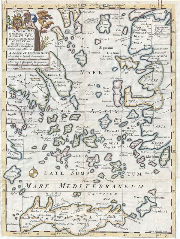
A New Map of the Islands of the Aegaean Sea, Together with The Island of Crete And the Adjoining Isles.
1712 (undated) 20 x 14.5 in (50.8 x 36.83 cm) 1 : 950000
1712 (undated) 20 x 14.5 in (50.8 x 36.83 cm) 1 : 950000
Description
This is a beautiful 1712 map of the Islands of the Aegean Sea by Edward Wells of Oxford. The map covers the Greek Isles or the Islands of the Aegean Sea from Myrina south to include Crete and from Cythera east as far as Rhodes. Includes the island of Euboea, originally believed to be a part of the mainland until it was separated by an earthquake and is the second largest island in Greece after Crete. The Cyclades, the Sporades, the Ionian Islands and several other Greek Islands are noted. Important cities, rivers and mountains are noted.
A decorative cartouche appears on the top left quadrant of the map featuring the coat of arms of the Duke of Gloucester. This, like many other Wells maps, is dedicated to Prince William, Duke of Gloucester and son of Queen Anne, who, when this map was being prepared, was a student at Oxford. Engraved by Sutton Nicholls and published by T. Bonwicke for the 1712 edition of Edward Wells' Atlas, A New Sett of Maps both of Ancient and Present Geography.
A decorative cartouche appears on the top left quadrant of the map featuring the coat of arms of the Duke of Gloucester. This, like many other Wells maps, is dedicated to Prince William, Duke of Gloucester and son of Queen Anne, who, when this map was being prepared, was a student at Oxford. Engraved by Sutton Nicholls and published by T. Bonwicke for the 1712 edition of Edward Wells' Atlas, A New Sett of Maps both of Ancient and Present Geography.
Cartographer
Edward Wells (1667 - 1727) was an English mathematician, geographer, and classical scholar based at Christ Church College, Oxford. Wells trained for the ministry but quickly found himself unsuited to religious life and instead applied for an academic position at Oxford, where he authored numerous well respected works on a wide range of mathematical and scientific topics. He tutored Prince William, the sickly son of Queen Anne, who was likely about 11 at the time this map was prepared. Wells dedicated nearly all of the maps in his atlas, A New Sett of Maps both of Ancient and Present Geography, to the young prince - quite possibly posthumously, as William died in July of 1700 shortly prior to the publication of the atlas. Nonetheless, Wells' geography proved popular and was published in number editions well into the 1730s. More by this mapmaker...
Source
Wells, E., A New Sett of Maps both of Ancient and Present Geography, (London, T. w. Bonwicke) c. 1712.
A New Sett of Maps both of Ancient and Present Geography was published by Edward Wells in various editions between 1701 and 1730. The publication contained some 40 maps all of which were dedicated to Prince William, Duke of Gloucester. Wells tutored the young prince at Christchurch, Oxford and seems to have developed a close relationship with him. At just 11 years of age, William died in 1700 and never had the opportunity to see the published work that he inspired. The atlas was intended for educational purposes with a focus on school use.
Condition
Very good. Original platemark visible. Minor wear along original fold lines. Narrow margins. Top margin shows rusted paperclip stains.