This item has been sold, but you can get on the Waitlist to be notified if another example becomes available, or purchase a digital scan.
1763 Bellin Map of Mauritius
IsledeFrance-bellin-1763$375.00


Title
Carte de l'Isle de France Dressée au Dépost des Cartes et Plans de la Marine Pour le Service des Vaisseaux du Roy Par Ordre de M. le Duc de Choiseul Colonel Général des Suisses et Grisons Ministre de la Guerre et de la Marine.
1763 (dated) 23 x 34.75 in (58.42 x 88.265 cm) 1 : 110000
1763 (dated) 23 x 34.75 in (58.42 x 88.265 cm) 1 : 110000
Description
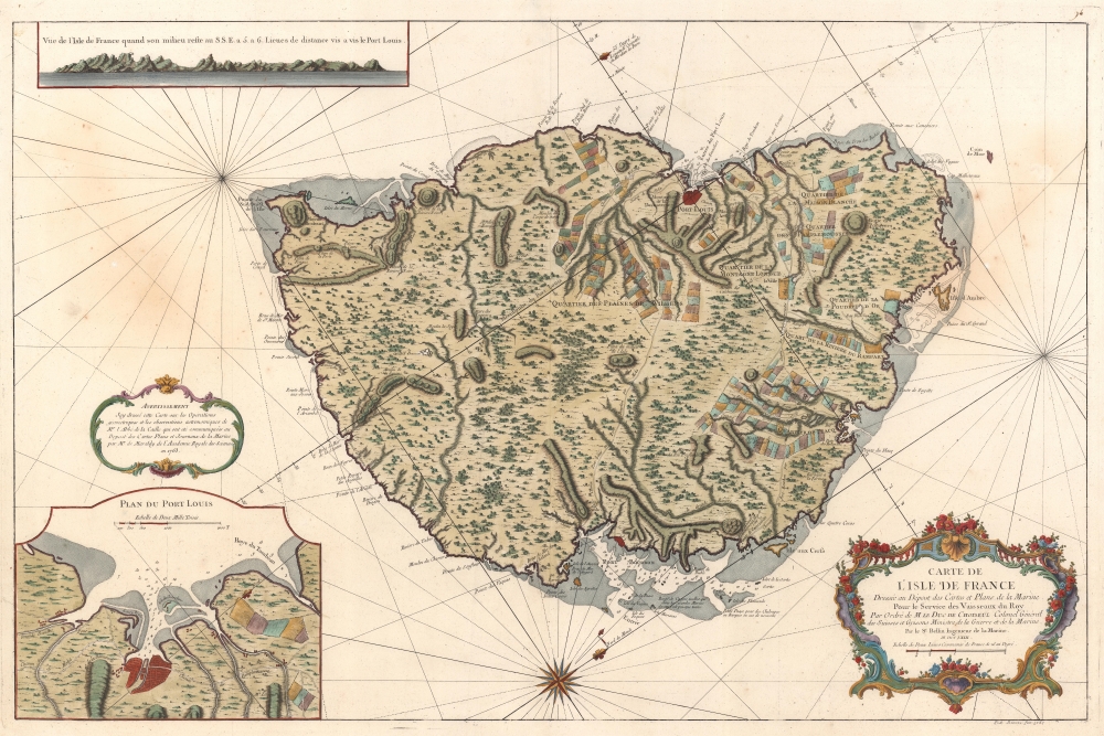
This is a 1763 Jacques-Nicolas Bellin map of Mauritius. It was issued near the peak of French colonial power, before the French Revolution and the Napoleonic Wars. Mauritius is here represented as the darling of French colonial power in the Indian Ocean. Not only was Isle de France a critical stopping point on the East India Trade (and not just for the French), under management of the French East India Company, it was also a highly productive agrarian colony.
A Closer Look
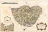
Mauritius, then Isle de France, is an island in the Indian Ocean east of Madagascar. Despite being framed as a nautical chart, this map offers better inland than maritime detail. We note topography, river courses, and even individual farm grants. Coastal points, river mouths, small islands, and other landmarks are noted along the coast. An inset in the lower left focuses on Port Louis, an important stopping point on the East India trade routes. A second inset, in the upper right, presents a coastal profile view from five or six leagues south-southeast of Port Louis. Such profiles played an important role in navigation, allowing mariners to recognize distant shorelines.Mauritius or Isle de France as a French Colony
From 1715 - 1810, Mauritius (Isle de France) was controlled by the French East India Company. During the French period, Port Louis developed into a major port, warehousing, and commercial center. The French East India Company gave land grants to colonists, soldiers, and workers which promoted the development of private farm enterprise, as grantees were required to cultivate their land for at least three years. One-tenth of each farm's production was returned to the French East India Company. In a bid to make the farms more profitable, each grantee was given twenty slaves. This alone dramatically increased the slave trade to Isle de France, with the number of slaves quadrupling between 1735 and 1740. The efforts were successful and Isle de France's production helped make France the largest European maritime trading power by the 1780s, with exports totaling £25 million, compared with Great Britain's £20 million. French dominance of Mauritius ended in 1810 during the Napoleonic Wars, when Britain captured the island.Publication History and Census
This map was drawn by Jacques-Nicolas Bellin, engraved by P. A. Rameau, and published by the Dépôt des Cartes de la Marine in 1763. We note five examples cataloged in OCLC which are part of the collections at the University of Michigan, the Bibliothèque Nationale de France, the Sächsische Landesbibliothek - Staats- und Universitätsbibliothek Dresden, the Universitätsbibliothek Bern, and the Biblioteca Nacional de España. It is rarely offered on the private market.CartographerS
Jacques-Nicolas Bellin (1703 - March 21, 1772) was one of the most important cartographers of the 18th century. With a career spanning some 50 years, Bellin is best understood as geographe de cabinet and transitional mapmaker spanning the gap between 18th and early-19th century cartographic styles. His long career as Hydrographer and Ingénieur Hydrographe at the French Dépôt des cartes et plans de la Marine resulted in hundreds of high quality nautical charts of practically everywhere in the world. A true child of the Enlightenment Era, Bellin's work focuses on function and accuracy tending in the process to be less decorative than the earlier 17th and 18th century cartographic work. Unlike many of his contemporaries, Bellin was always careful to cite his references and his scholarly corpus consists of over 1400 articles on geography prepared for Diderot's Encyclopedie. Bellin, despite his extraordinary success, may not have enjoyed his work, which is described as "long, unpleasant, and hard." In addition to numerous maps and charts published during his lifetime, many of Bellin's maps were updated (or not) and published posthumously. He was succeeded as Ingénieur Hydrographe by his student, also a prolific and influential cartographer, Rigobert Bonne. More by this mapmaker...
Dépôt des Cartes et Plans de la Marine (fl. 1720 - present), often called the Dépôt de Marine, was a French hydrographic mapping organization founded in 1720 under Charles-Hercule of Albert de Luynes (1674 - 1734). Much like the U.S. Coast Survey, the British Admiralty, and the Spanish Deposito Hydrografico, the Dépôt was initiated as a storehouse and distribution center of existing nautical and marine charts. Eventually the Dépôt initiated its own mapping activities in an attempt to improve and expand upon existing material. Some of the more prominent cartographers and hydrographers associated with the of Dépôt des Cartes were, Philippe Buache, Jacques-Nicholas Bellin, Giovanni Rizzi-Zannoni, Rigobert Bonne, and Jean Nicolas Buache. Learn More...
Condition
Very good. Light wear along original centerfold.
References
OCLC 1291428735, 494572177, 956305893, 776736155.