This item has been sold, but you can get on the Waitlist to be notified if another example becomes available, or purchase a digital scan.
1752 Bellin Map of Mariana Island (Guam and Tinian)
IslesMarianes-bellin-1752$75.00

Title
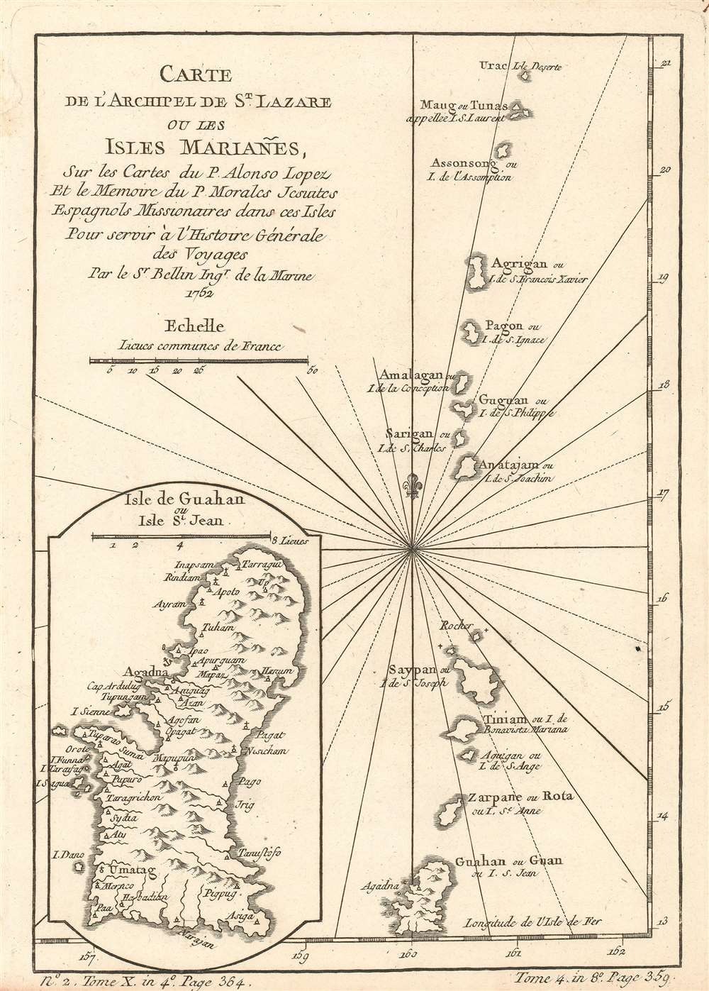
Carte de l'Archipel de St. Lazare ou les isles Mariañes.
1752 (dated) 8.5 x 6 in (21.59 x 15.24 cm) 1 : 1506880
1752 (dated) 8.5 x 6 in (21.59 x 15.24 cm) 1 : 1506880
Description
This is a 1752 Jacques-Nicolas Bellin map of the Marianas Islands, a crescent-spaped archipelago in the western North Pacific Ocean. The map depicts the archipelago from Farallon de Pajaros (Urac) to Guam and illustrates fourteen islands including the Maug Islands, Asuncion Island (Assonsong), Pagan (Pagon), Saipan, Tinian, and Guam. A fairly detailed inset map of Guam is situated in the lower left corner and labels villages and a handful of coastal sites. Agadna is labeled as a safe port by the inclusion of an anchor emblem.
A Short Colonial History of the Mariana Islands
The first colonial power to occupy the Marianas was Spain, when an expedition trying to circumnavigate the Earth discovered the islands in 1521. Spain sold the Marianas, along with the Carolines and Pelew Islands, to Germany is 1899 following their defeat in the Spanish-American War. Germany lost control of the Marianas during World War I when they were captured by the Japanese, who held them until the United States captured Saipan and Tinian during World War II. Today, the Northern Mariana Islands are now a U.S. commonwealth, while Guam is a U.S. territory.Census and Publication History
This map was created by Jacques-Nicolas Bellin for publication in in Abbé Prévost's Histoire Générale des Voyages.Cartographer
Jacques-Nicolas Bellin (1703 - March 21, 1772) was one of the most important cartographers of the 18th century. With a career spanning some 50 years, Bellin is best understood as geographe de cabinet and transitional mapmaker spanning the gap between 18th and early-19th century cartographic styles. His long career as Hydrographer and Ingénieur Hydrographe at the French Dépôt des cartes et plans de la Marine resulted in hundreds of high quality nautical charts of practically everywhere in the world. A true child of the Enlightenment Era, Bellin's work focuses on function and accuracy tending in the process to be less decorative than the earlier 17th and 18th century cartographic work. Unlike many of his contemporaries, Bellin was always careful to cite his references and his scholarly corpus consists of over 1400 articles on geography prepared for Diderot's Encyclopedie. Bellin, despite his extraordinary success, may not have enjoyed his work, which is described as "long, unpleasant, and hard." In addition to numerous maps and charts published during his lifetime, many of Bellin's maps were updated (or not) and published posthumously. He was succeeded as Ingénieur Hydrographe by his student, also a prolific and influential cartographer, Rigobert Bonne. More by this mapmaker...
Condition
Very good. Even overall toning. Light wear along original fold lines. Close bottom margin. Blank on verso.
References
OCLC 53992157