This item has been sold, but you can get on the Waitlist to be notified if another example becomes available, or purchase a digital scan.
1950 Israeli / Hebrew Barlevi Pictorial Map of Israel
Israel-barlevi-1950$275.00

Title
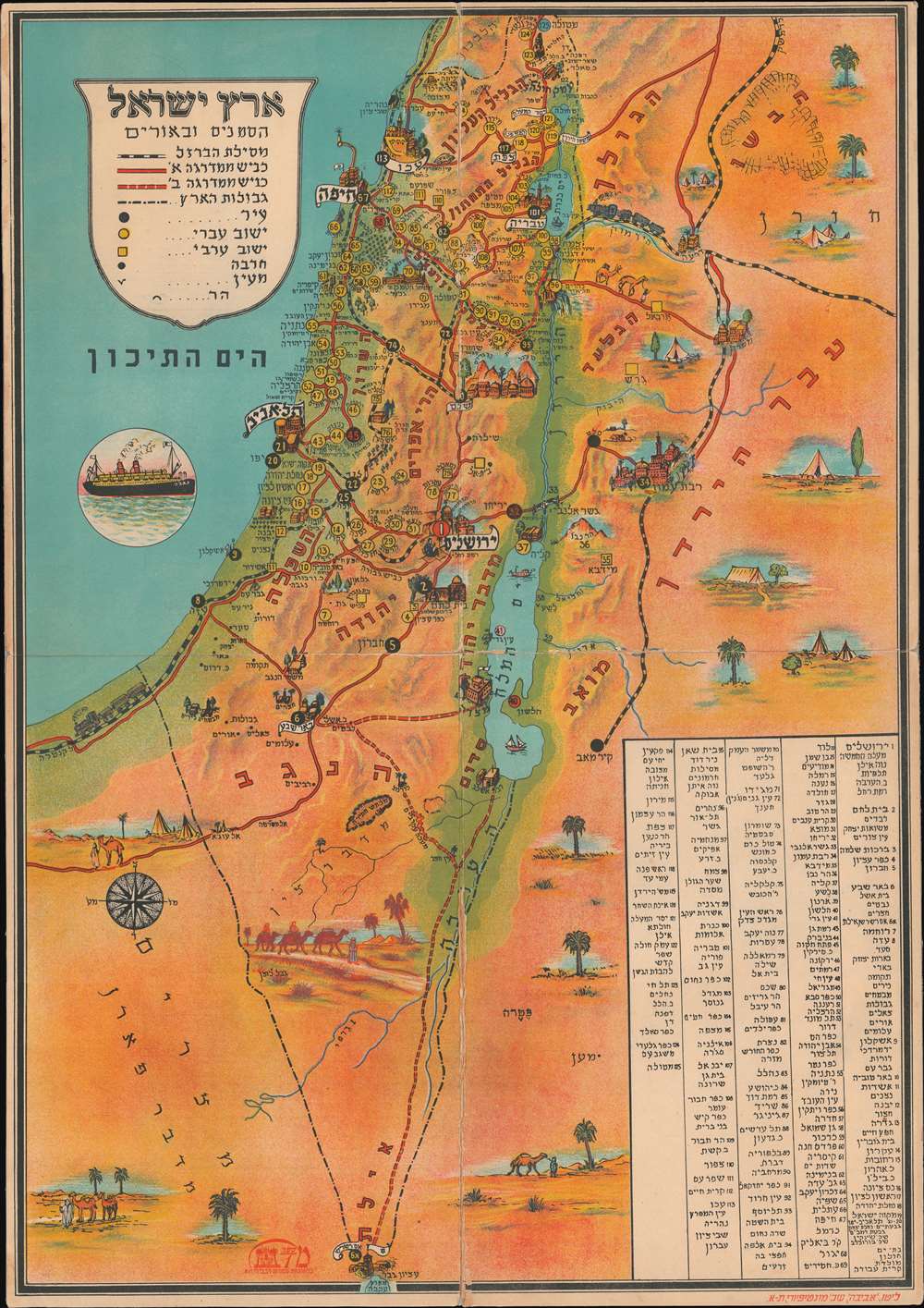
Eretz Israel Hasanim and Orim / אריך ישראל הסנים ובאורים
1950 (undated) 26.25 x 18 in (66.675 x 45.72 cm) 1 : 638000
1950 (undated) 26.25 x 18 in (66.675 x 45.72 cm) 1 : 638000
Description
A striking c. 1950 Hebrew Zionist chromolithograph pictorial map and game board by Binyamin Bar-Levi, Tel-Aviv. This map / game was issued shortly after Israel's founding. Important cities and historical sites are identified pictorially. The map illustrates railroad lines connecting Israel to the surrounding countries - many of which are now defunct. Some 125 locations are numbered with a corresponding index in the lower right. Interestingly, yellow circles represent Israeli settlements, while yellow squares represent Arab settlements.
Zionism for Children
Bar-Levi was an ardent Zionist and this map, like most of his work, is intended to indoctrinate Jewish youth into the Zionist ideology. While the map offers no overtly anti-Arab elements the message is clear, by working over the map, the youth connected closely with the land and Jewish history within Israel - much of it dating to the Second Temple Period. A large steamer in the Mediterranean underscores Jewish immigration. While Israel itself is full of roads, railways, and locations of interest, the surrounding country is barren, full of tents, camels, and empty desert - emphasizing Israel as the 'land of milk and honey'. The whole underscores a singularly Zionistic concept - this is your land, come here and build.Chromolithography
Chromolithography is a color lithographic technique developed in the mid-19th century. The process involved using multiple lithographic stones, one for each color, to yield a rich composite effect. Oftentimes, the process would start with a black basecoat upon which subsequent colors were layered. Some chromolithographs used 30 or more separate lithographic stones to achieve the desired product. Chromolithograph color could also be effectively blended for even more dramatic results. The process became extremely popular in the late 19th and early 20th centuries, when it emerged as the dominate method of color printing. The vivid color chromolithography produced made it exceptionally effective for advertising and propaganda imagery.Publication History and Census
This map was published in Tel Aviv by the game maker Binyamin Bar-Levi. We do not know if this map is associated with an actual game, or if so, how it might be played as there are no clear 'game indicators' present.Cartographer
Binyamin Bar-Levi (fl. c. 1940 - 1950) was an Israeli publisher of children's books, maps, graphics, and games based in Tel Aviv. Bar-Levi is considered a pioneer in the Israeli children's games industry. He published more than 250 games and children's works - many of which were based upon travel and cartography, with rich historical or geographical elements. He was an ardent Zionist, and his work was designed to indoctrinate Jewish children into Zionist values, goals, and enterprise. More by this mapmaker...
Condition
Average. Map on thick stock. Splits on seams from frequent folding. The whole has been stabilized on linen.