1956 Szapiro Map of the Middle East During the Suez Crisis
IsraelSinaiEnglish-szapiro-1956$500.00

Title
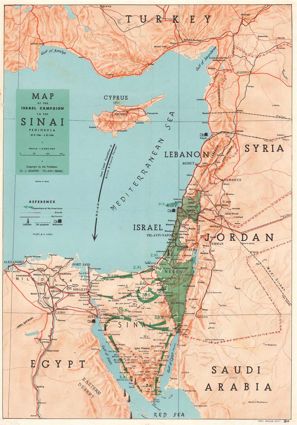
Map of the Israel Campaign in the Sinai Peninsula.
1956 (undated) 19 x 13.5 in (48.26 x 34.29 cm) 1 : 2500000
1956 (undated) 19 x 13.5 in (48.26 x 34.29 cm) 1 : 2500000
Description
This is a 1956 Dr. J. Szapiro map of the Middle East centered on Israel during the 1956 Suez Crisis, which is also known as the Second Arab-Israeli War. Tracing the events of the war, the map depicts the region from Alexandria, Egypt to Syria and Saudi Arabia, and from Turkey to the Red Sea. Israel is shaded in green, making it stand out in contrast to the other countries in the region, and the movements of the Israeli armed forces across the Sinai Peninsula are also illustrated in green. These arrows are dated, allowing the viewer to follow the actions of the Israelis throughout the war. A notation in the Mediterranean Sea also marks the presence of the British and French Suez Canal Expedition. Roads and railways are also illustrated, as are oil fields, oil pipelines, and refineries.
The Suez Crisis or the Second Arab-Israeli War
The Suez Crisis is also known by several other names, including the Second Arab-Israeli War, the tripartite aggression in the Arab world, and the Sinai War in Israel. This conflict was an invasion of Egypt by Israel, followed closely by the United Kingdom and France, to gain Western control of the Suez Canal after Egyptian President Gamal Abdel Nassar nationalized the canal. The conflict lasted from October 29, 1956 – November 7, 1956. Following the Israeli invasion of the Egyptian Sinai Peninsula on October 29, the U.K. and France issued a joint ultimatum to end the fighting, which was ignored. This led to Britain and France landing paratroopers along the Suez Canal on November 5, which defeated the Egyptian forces guarding the canal. Through political pressure, the United States, the Soviet Union, and the United Nations forced the withdrawal of all three nations from the Sinai. However, the Israelis occupied the peninsula until March 1957. Later it became clear that Israel, France, and the United Kingdom had coordinated their plans before the conflict began. In the end, the episode humiliated Britain and France, with some historians stating that the episode signified the end of Britain's reign as a significant world power. It also achieved the opposite of one of their stated goals: instead of removing Nassar from power, the Suez Crisis only strengthened his position.Publication History and Census
This map was created by Dr. J. Szapiro and published the Israel American Offset in Tel Aviv in 1956. There are two editions of this map: the present example, which is printed only in English, and a second edition, published in both English and Hebrew. The present example appears to be uncataloged in OCLC and the bilingual edition is part of three institutional collections.Condition
Very good. Exhibits wear along original fold lines. Light soiling. Blank on verso.