This item has been sold, but you can get on the Waitlist to be notified if another example becomes available, or purchase a digital scan.
1815 Heymann Dissected Wall Map of Italy
Italia-heymann-1815$500.00

Title
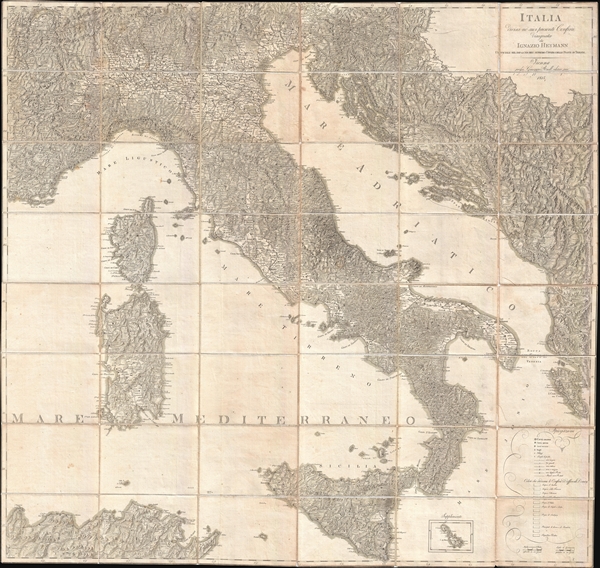
Italia Divisa ne' suoi Presenti Confini.
1815 (dated) 50 x 44 in (127 x 111.76 cm) 1 : 1080000
1815 (dated) 50 x 44 in (127 x 111.76 cm) 1 : 1080000
Description
A beautifully engraved 1815 large format postal map of Italy by the Austrian cartographer Ignaz Heymann. This remarkable map covers from Lake Geneva to Sicily and from Toulon to Corfu, covering in the process all of Italy, Sardinia, Corsica, and Sicily, as well as parts of Tunisia in north Africa, Istria, and Monte Negro. Naturally for a map of this size the detail throughout is outstanding, with even tiny hamlets identified. Mountains in particular are beautifully rendered in profile with additional shading to further elucidate terrain. An inset in the lower right details Malta.
Heymann originally published this map in 1806. It received several updates, this 1815 edition being the last under Heymann, published in the very year his death. It was issued in Vienna and edited by Giuseppe Riedl.
Heymann originally published this map in 1806. It received several updates, this 1815 edition being the last under Heymann, published in the very year his death. It was issued in Vienna and edited by Giuseppe Riedl.
Cartographer
Ignaz Heymann (1765-1815) was an Austrian postmaster, publisher, and cartographer active in Italy during late 18th and early 19th century. Heymann was born in Karansebes (modern day Romania). At age 7 he moved with his parents to Milan where, as a young man, he attended the Jesuit College of Brera. In 1874 he traveled throughout Italy, visiting Florence, Rome, Naples, and Venice, finally landing in Gorizia, where he took a job with the local tax regulatory commission. Afterwards he relocated to Trieste where he found work with the Postal Service. The Napoleonic occupation of Trieste in 1809 forced him to move again, this time to Vienna, where he again took work with the postal service. He retired from the postal service in 1811, after 25 years of service. For his distinguished civil service to the Hapsburg Empire he was awarded the Große Goldene Civil-Verdienstmedaille (Great Golden Civil Merit Medal). He published a number of large format maps, most associated with the postal service. His earliest cartographic studies appeared in 1797. Numerous maps followed, most depicting various parts of the Hapsburg Empire and Italy. Heymann died in 1815. More by this mapmaker...
Condition
Good condition. Light soiling and even overall toning. The original linen is naturally week and reinforced in places. Dissected and mounted in 48 panels.
References
OCLC 741020616. BLKÖ, 8 (1862), p. 462. Wiener Zeitung, 25.3.1807. Vaterländische Blätter für den österreichischen Kaiserstaat, 1815, p. 149-150. Dörflinger II, KIC 29b. Cf. Dörflinger II, p. 735ff.