This item has been sold, but you can get on the Waitlist to be notified if another example becomes available, or purchase a digital scan.
1770 Janvier Map of Italy
Italy-janvier-1770$125.00

Title
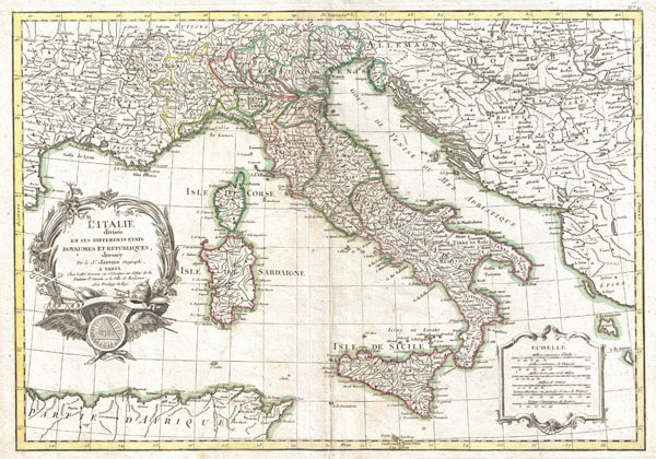
L'Italie divisee en ses differents etats Royaumes et Republiques.
1770 (undated) 12.5 x 17.5 in (31.75 x 44.45 cm)
1770 (undated) 12.5 x 17.5 in (31.75 x 44.45 cm)
Description
A beautiful example of Le Sieur Janvier's 1770 decorative map of Italy. Covers from the Gulf of Eyon eastward to include all of Corsica, Sardinia, Italy, the Adriatic, and parts of Hungary and Turkey in Europe. Extends south to include adjacent parts of Africa and north as far as Lake Geneva. An elaborate title cartouche rendered with Papal accoutrements appears in the lower left hand quadrant. A secondary cartouche bearing a six distance scales appears in the lower right.
This map shows the Italian peninsula prior to its struggle for national solidarity which would emerge as a movement about 50 years later in the early 19th century. The peninsula is divided into numerous independent states, duchies, republics, kingdoms and, of course, the Papal States (States of the Church).
Overall, a fine map of the region. Drawn J. Janvier c. 1770 for issue as plate nos. 10 in Jean Lattre's 1776 issue of the Atlas Moderne.
CartographerS
Jean Denis Janvier (fl. 1746 - 1776), sometime also known as 'Robert', was a Paris based cartographer active in the mid to late 18th century. Janvier signed his maps Signor Janvier. By the late 18th century, Janvier was awarded the title of 'Geographe Avec Privilege du Roi' and this designation appears on many of his later maps. Janvier worked with many of the most prominent French, English and Italian map publishers of his day, including Longchamps, Faden, Lattre, Bonne, Santini, Zannoni, Delamarche, and Desnos. More by this mapmaker...
Jean Lattré (170x - 178x) was a Paris based bookseller, engraver, globe maker, calligrapher, and map publisher active in the mid to late 18th century. Lattré published a large corpus of maps, globes, and atlases in conjunction with a number of other important French cartographic figures, including Janvier, Zannoni, Bonne and Delamarche. He is also known to have worked with other European cartographers such as William Faden of London and the Italian cartographer Santini. Map piracy and copyright violations were common in 18th century France. Paris court records indicate that Lattré brought charges against several other period map publishers, including fellow Frenchman Desnos and the Italian map engraver Zannoni, both of whom he accused of copying his work. Lattré likes trained his wife Madame Lattré (né Vérard), as an engraver, as a late 18th century trade card promotes the world of 'Lattré et son Epouse.' Lattré's offices and bookshop were located at 20 rue St. Jaques, Paris, France. Later in life he relocated to Bordeaux. Learn More...
Source
Lattre, Jean, Atlas Moderne ou Collection de Cartes sur Toutes les Parties du Globe Terrestre, c. 1775.
Condition
Very good condition. Original centerfold exhibits minor toning. Blank on verso.
References
Rumsey 2612.027. Phillips (Atlases) 664. National Maritime Museum, 215.