This item has been sold, but you can get on the Waitlist to be notified if another example becomes available, or purchase a digital scan.
1762 Janvier Map of Italy
Italy2-janvier-1762$137.50

Title
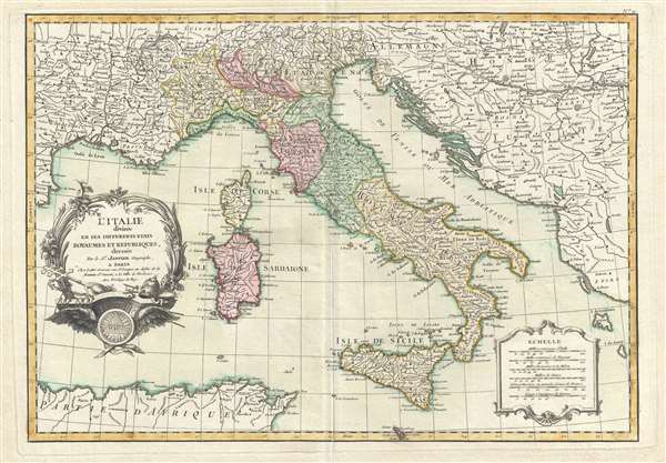
l'Italie divisée en ses Differents Etats Royaumes et Republiques.
1762 (undated) 12.25 x 17.5 in (31.115 x 44.45 cm) 1 : 4000000
1762 (undated) 12.25 x 17.5 in (31.115 x 44.45 cm) 1 : 4000000
Description
This is a 1762 Jean Janvier map of Italy. The map depicts from the Gulf of Lyon to parts of Hungary and Turkey in Europe and from Lake Geneva in Switzerland to Sicily and North Africa. Depicting the Italian peninsula prior to its struggle for national solidarity, the peninsula remains divided into numerous independent states, duchies, republics, kingdoms and the Papal States (Etat de l'Eglise). Myriad rivers and numerous cities and towns are labeled throughout Italy and the adjacent territory in France and across the Adriatic (also referred to here as the Golfe de Venise, or the Gulf of Venice). Both Corsica and Sardinia are depicted. An elaborate title cartouche featuring Papal accoutrements appears on the lower left. A secondary cartouche bearing six distance scales appears on the lower right.
This map was drawn by Jean Janvier and included in the first edition of Jean Lattre's 1762 issue of the Atlas Moderne.
This map was drawn by Jean Janvier and included in the first edition of Jean Lattre's 1762 issue of the Atlas Moderne.
CartographerS
Jean Denis Janvier (fl. 1746 - 1776), sometime also known as 'Robert', was a Paris based cartographer active in the mid to late 18th century. Janvier signed his maps Signor Janvier. By the late 18th century, Janvier was awarded the title of 'Geographe Avec Privilege du Roi' and this designation appears on many of his later maps. Janvier worked with many of the most prominent French, English and Italian map publishers of his day, including Longchamps, Faden, Lattre, Bonne, Santini, Zannoni, Delamarche, and Desnos. More by this mapmaker...
Jean Lattré (170x - 178x) was a Paris based bookseller, engraver, globe maker, calligrapher, and map publisher active in the mid to late 18th century. Lattré published a large corpus of maps, globes, and atlases in conjunction with a number of other important French cartographic figures, including Janvier, Zannoni, Bonne and Delamarche. He is also known to have worked with other European cartographers such as William Faden of London and the Italian cartographer Santini. Map piracy and copyright violations were common in 18th century France. Paris court records indicate that Lattré brought charges against several other period map publishers, including fellow Frenchman Desnos and the Italian map engraver Zannoni, both of whom he accused of copying his work. Lattré likes trained his wife Madame Lattré (né Vérard), as an engraver, as a late 18th century trade card promotes the world of 'Lattré et son Epouse.' Lattré's offices and bookshop were located at 20 rue St. Jaques, Paris, France. Later in life he relocated to Bordeaux. Learn More...
Source
Lattre, Jean, Atlas Moderne ou Collection de Cartes sur Toutes les Parties du Globe Terrestre Par Plusieurs Auteurs, Paris, 1762.
Condition
Very good. Original platemark visible. Minor wear along original centerfold. Overall toning. Vero repair of centerfold separation. Closed margin tears professionally repaired on verso. Blank on verso.
References
Rumsey 2612.027. Phillips (Atlases) 664. National Maritime Museum, 215.