This item has been sold, but you can get on the Waitlist to be notified if another example becomes available, or purchase a digital scan.
1939 Sundberg Map of Italy and its New Empire on the Eve of WWII
ItalyEmpire-sundberg-1939$137.50

Title
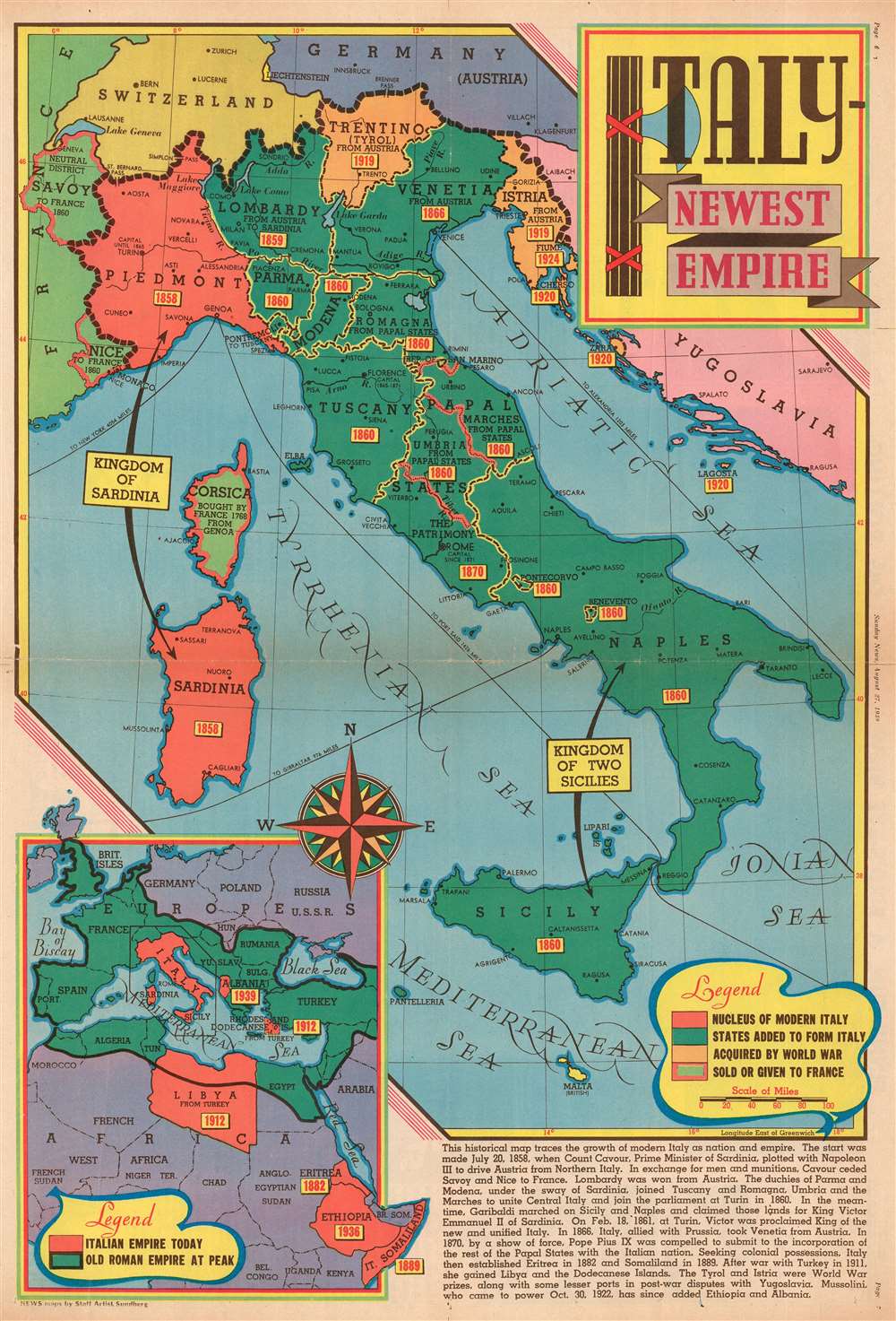
Italy - Newest Empire.
1939 (dated) 22.25 x 15 in (56.515 x 38.1 cm) 1 : 3000000
1939 (dated) 22.25 x 15 in (56.515 x 38.1 cm) 1 : 3000000
Description
This is a 1939 Edwin Sundberg map of Italy published days before the outbreak of World War II. The map depicts the region from France to Yugoslavia and from Germany and Switzerland to Sicily and the Mediterranean Sea. Focusing on the development of Italy from a collection of principalities and duchies into a unified country, small yellow boxes with red font boldly declare when each area was incorporated into the whole. An inset map in the lower left corner highlights Italy's territorial gains outside its home peninsula, placing its colonial adventurism in Africa and its war gains in contrast with the Ancient Roman Empire, which served as Mussolini's inspiration.
After Mussolini came to power in 1922, he continued the Italian drive for expansion, conquering Ethiopia in 1936 after winning the Second Italo-Ethiopian War. Then, Italy invaded the Kingdom of Albania in April 1939, deposed King Zog I, and conquered the country in five days. Albania was then annexed by the Italian Empire as a protectorate.
The Italian Empire
A narrative in the lower right corner provides more context, explaining that the Prime Minister of Sardinia, Count Cavour, conspired with French Emperor, to evict Austria out of northern Italy. Napoleon III provided men and arms and received Nice and Savoy for his trouble. Lombardy was won from Austria in 1859, and Parma, Modena, Romagna, Tuscany, the Marches and Umbria joined with Sardinia to unite central Italy in 1860. Garibaldi conquered Naples and Sicily for King Victor Emmanuel II that same year, who was then proclaimed King of the new unified Italy on February 18, 1861. The remaining Papal States managed to hold out for another nine years, but eventually they succumbed to pressure and joined the Italian nation. Italy established two African colonies, Eritrea and Somaliland, in 1882 and 1889 respectively, and won Libya and the Dodecanese Islands from Turkey after winning a war in 1911.After Mussolini came to power in 1922, he continued the Italian drive for expansion, conquering Ethiopia in 1936 after winning the Second Italo-Ethiopian War. Then, Italy invaded the Kingdom of Albania in April 1939, deposed King Zog I, and conquered the country in five days. Albania was then annexed by the Italian Empire as a protectorate.
Publication History and Census
This map was created by Edwin Sundberg and published by the Sunday News on August 27, 1939. Even though Sundberg's works were produced for a New York City newspaper, his maps vary in scarcity today. We have been unable to locate any other known examples of this map in institutional collection or on the private market.Cartographer
Edwin L. Sundberg (1898 - 1978) was an American cartographer known for his pictorial pieces. Sundberg was a staff artist for the Sunday News in New York City and eventually became Chief Cartographer in charge of a small staff of artists. More by this mapmaker...
Condition
Very good. Newsprint. Closed margin tears professionally repaired on verso. Wear along original fold lines. Verso reinforcements along original centerfold. Text and printed photographs on verso.