This item has been sold, but you can get on the Waitlist to be notified if another example becomes available, or purchase a digital scan.
1840 Black Map of North Italy: Tuscany, Piedmont, Venice
ItalyNorth-black-1840$75.00

Title
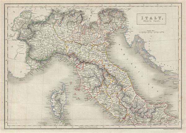
Italy, North Part.
1840 (undated) 11.5 x 16 in (29.21 x 40.64 cm)
1840 (undated) 11.5 x 16 in (29.21 x 40.64 cm)
Description
A fine example of Adam and Charles Black's 1840 map of northern Italy. The map covers the island of Corsica and Northern Italy, depicting the regions of Tuscany, Modena, Parma, the Sardinian States, Venetian Lombardy, the States of the Church, and Corsica. It also shows the northern part of the Kingdom of Naples. As this map was drawn, revolutionary sentiments favoring the unification of Italy were gaining popularity under Giuseppe Garibaldi, paving the way to Italian solidarity. This map was engraved by S. Hall for issue in the 1840 edition of Black's General Atlas.
Cartographer
Charles and Adam Black (fl. 1807 - present) were map and book publishers based in Edinburgh. Charles and his uncle, Adam, both of Edinburgh, Scotland, founded their publishing firm in 1807. They published a series of maps and atlases throughout the 19th century. In addition to an array of atlases, the Black firm is known for their editions of the Encyclopedia Britannica (1817 - 1826) and the first publishing of Sir Walter Scott's novels in 1854. In 1889 the A. & C. Black publishing house moved to London where it remains in operation to this day. More by this mapmaker...
Source
Hall, Sydney, Black's General Atlas: A series of Fifty-Four Maps from the Latest and Most Authentic Sources, Engraved on Steel, In the First Style of the Art, (Edinburgh: Adam and Charles Black) 1840.
Condition
Very good. Blank on verso. Original platemark visible.
References
Philips (atlases) 4334.