This item has been sold, but you can get on the Waitlist to be notified if another example becomes available, or purchase a digital scan.
1944 U.S. Navy Map of Iwo Jima with Manuscript Notations
IwoJima-usnavy-1944$3,500.00

Title
Iwo Jima Volcano Islands.
1944 (dated) 39.75 x 26.25 in (100.965 x 66.675 cm) 1 : 10000
1944 (dated) 39.75 x 26.25 in (100.965 x 66.675 cm) 1 : 10000
Description
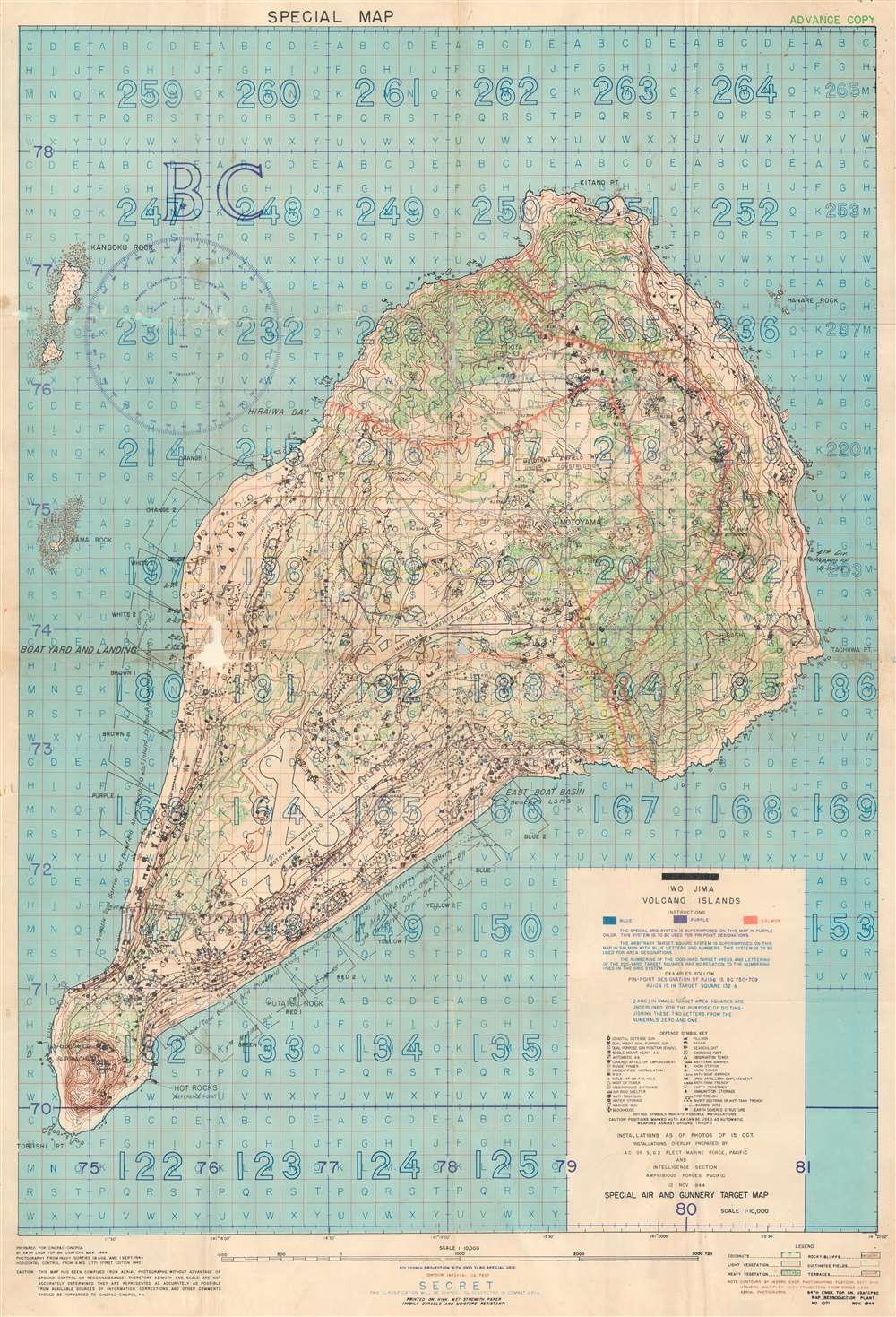
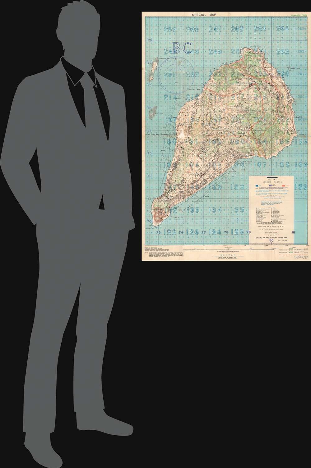
This is a 1944 U.S. Navy map of Iwo Jima. Depicting the entirety of the island, Iwo Jima's terrain is illustrated in detail, with contour lines emphasizing changes in elevation while color highlights changes in vegetation. Both airfields are identified and thirty-four symbols mark locations of Japanese positions, including pillboxes, radar, anti-tank guns, and machine guns. Unfortunately for the Marines landing on Iwo Jima, these installations were identified in November 1944, three months before the invasion in February 1945, meaning that this map is likely inaccurate. The invasion beaches are noted along the southern coasts of the island and their codenames, including Yellow 1 and Yellow 2, are provided. A grid meant to be used for directing airstrikes, artillery fire, and bombardment from naval vessels is superimposed over the entire map and instructions for how to direct this fire are provided.
Manuscript Notations
Manuscript notations throughout this map follow the battle from the landings on February 19 until March 18, eight days before the battle was declared over. Battle lines in various colors progress along the island, with each line identified by the month and day. Other manuscript notations identify the landing zones of the 5th Marine Division, 4th Marine Division, and the 3rd Marine Division.The Map's Original Owner
This map was owned by Edward Leroy 'Roy' Jones III (January 29, 1920 - October 31, 2006), a member of the 133rd Naval Construction Battalion. Jones, from Arizona, and the 133rd landed on D-Day at Iwo Jima with the 4th Marine Division on the Yellow and Blue beaches. The 133rd was one of the units tasked with getting the airfield operational after it was captured three days after D-Day. Very little is known about Jones. From newspaper articles we know that he served two years with the Seabees after graduating from the University of Arizona in 1943 and was discharged in February 1946. He married Lola Beth Thomas on June 22, 1946, in Bisbee, Arizona. He died in San Diego, California, and is buried at Ft. Rosecrans National Cemetery.The Battle of Iwo Jima
The Battle of Iwo Jima (February 19 - March 26, 1945) was an American invasion of the island of Iwo Jima. One of the Japanese Volcano Islands, Iwo Jima translates to 'Sulphur Island' and is 750 miles south of Tokyo. Over the course of the thirty-six-day battle, American forces suffered over 6,800 killed in battle (of which 6,102 were Marines) and over 27,000 casualties. Of the approximately 20,000 Japanese soldiers defending the island, only 216 were taken prisoner. Iwo Jima is still remembered for its brutality and its heavy cost. Since the battle, the island's significance as a strategic asset has become disputed. In April 1945, less than a month after the end of the battle, retired Chief of Naval Operations William V. Pratt was quoted in Newsweek as saying that theexpenditure of manpower to acquire a small, God-forsaken island, useless to the Army as a staging base and useless to the Navy as a fleet base…[one] wonders if the same sort of airbase could not have been reached by acquiring other strategic localities at lower cost'.The iconic photograph taken by Joe Rosenthal of six Marines raising the U.S. flag at the top of Mount Suribachi, which subsequently became the U.S. Marine Corps War Memorial, is perhaps the most recognizable piece of the battle.
Creation of the Map
The installations overlay was prepared by the 'A C of S, G2 Fleet Marine Force, Pacific and Intelligence Section Amphibious Forces Pacific 12 Nov 1944'. Translated from military speak that means it was created by the Assistant Chief of Staff, Intelligence (the G2 Section is the Intelligence Section of U.S. Army and Marine Corps staff) of the Marines (which was referred to administratively as the 'Fleet Marine Forces') likely on the staff of the Commander of the Amphibious Forces Pacific. The map was compiled from photography from Navy sorties from August 19 through September 1, 1944. The contours were executed by the 1633rd Engineer Photomapping Platoon in September 1944 using aerial photographs and was prepared for CINCPAC - CINCPOA (Commander in Chief Pacific - Commander in Chief Pacific Operations Areas) by the 64th Engineer Topographic Battalion in November 1944. It is unclear if the 64th had any more involvement in the creation of this piece than its printing.Publication History and Census
This map was created for CINCPAC - CINCPOA in November 1944 by the 64th Engineer Topographic Battalion. We note a single example cataloged in OCLC, at the Wisconsin Veterans Museum Research Center. We note a handful of other examples of this map appearing on the market in recent years, one without any manuscript notations and another bearing completely different notations. Considering the unique nature of the notations present on this map tracing the battle from beginning to end, this is a unique piece that would make a wonderful addition to any collection.Condition
Fair. Areas of loss. Soiling. Wear along original fold lines. Verso repairs to fold separations. Manuscript notations tracing advance of battle from landing to final day.
References
OCLC 263880544.