
1913 / 1919 Grosser City Plan or Map of Jacksonville, Florida

This item has been sold.
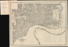
Map of Jacksonville Duval County Florida. / Jacksonville Street Guide and City Directory with Index Map.
The Gateway City.
- Digital Map Information
- Suitable for large format printing
- Full resolution TIFF file
- ICC color profile embedded
- Delivered instantly via download link
The Gateway City.
This is a 1913 map of Jacksonville, Florida, issued in a 1919 street guide and city directory published by J.C. Grosser of the Florida News Co. It captures the city in the midst of breakneck development, recovering from the 1901 Great Fire, operating as the gateway to the Florida Land Boom, and attracting a long-forgotten film industry that, at the time, rivaled Hollywood.A Closer Look
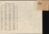
This map covers the contemporary city of Jacksonville, which expanded continuously in subsequent decades, such that it now covers 900 square miles, most of Duval County (the city and county governments having consolidated in 1968), and is the largest city by total area in the contiguous United States. At the time of this map's publication, however, the city was limited to today's downtown portion of Jacksonville. City blocks and lots are numbered throughout, while streets are labeled and also listed in an index on the verso corresponding to a grid surrounding the map. Rail lines, waterways, ferry routes, and pierhead and bulkhead lines along the shore are also traced and labeled throughout. Some of the larger lots have their owners labeled, generally railways or industrial enterprises, as well as city property, parks, and cemeteries, though some individual landowners hold such plots, especially in the northern part of the city. One such lot in the northern part of the city is labeled 'Cookman Institute,' at that time a co-ed high school that in 1923 merged with the Daytona Educational and Industrial Training School for Negro Girls to create the Daytona Cookman Collegiate Institute, now Bethune-Cookman University, a Historically Black University located in Daytona Beach.Historical Context
Despite having suffered greatly in the Great Fire of 1901, which burned down most of downtown Jacksonville, by the time this map was produced, the city had recovered handsomely. Dubbed the 'Gateway City' due to its extensive rail network and expanding deepwater port, it served as the essential transit point for tourists, land speculators, and northern capital moving south during the Florida Real Estate Boom. Architectural pioneer Henry John Klutho spearheaded a dramatic physical transformation of the city, erecting Florida's earliest modern skyscrapers and introducing 'Prairie School' style to the downtown core. Thus, by the end of the 1910s, Jacksonville was a financial and logistical anchor for Florida's accelerating land speculation, and the city's population was approaching 100,000, having been less than 30,000 at the start of the century.In these years, Jacksonville also earned national and international renown as a major center for the emerging film industry. Lured by warm weather (most film studios were hitherto based in New York City), consistent sunlight, cheap labor, and varied natural scenery, more than 30 silent-picture studios established production hubs in the city, including industry pioneers such as Kalem, Lubin, Thanhouser, and Metro. Early screen legends like Oliver Hardy began their careers in Jacksonville, which hosted hundreds of productions ranging from comedies to 'race films,' which featured African-American cast members in dignified roles and were intended for Black audiences (produced by Norman Studios). However, local frustration over wild stunt filming, disrupted streetcars, and rowdy production crews became a central issue in the 1917 mayoral race, leading to the election of anti-film candidate John W. Martin. This local political friction, paired with the allure of Southern California's varied topography, ultimately prompted studios to migrate west to Hollywood.
Publication History and Census
This is a reduced version of a large (107 x 132 cm) 1913 map of Jacksonville 'drawn by B.L.H and H.H.F.' of the City Engineering Department (OCLC 70803853) that is held by the Newberry Library and the University of Wisconsin - Milwaukee (the OCLC also records an example at Western Michigan University but their own catalog does not reflect this). The present map and guide with the reduced map was published in 1919 by the Florida News Co., which notes J.C. Grosser as a general manager. Examples are held by the University of North Florida and the Boston Public Library's Leventhal Map Center.Cartographer
John Charles Grosser (February 21, 1863 - December 12, 1929) was a newspaper man in Jacksonville, Florida in the early 20th century. He was born in Schuylkill County, Pennsylvania to German immigrant parents from Prussia. Having initially apprenticed to become a plasterer, Grosser and his first wife had relocated to Gainesville, Florida by 1895 if not earlier. Following his wife's death that year, Grosser relocated to South Jacksonville and remarried (though his second wife also died young, in 1903), working for some twenty years as a railway mail clerk. By the late 1910s, he had shifted to the newspaper industry and was working as a 'General Manager' for the Florida News Co., which was based in Tampa, suggesting that Grosser was the local manager of the company in Jacksonville. Soon thereafter, Grosser devoted his energies fully to real estate investment, cashing in no doubt on the Florida Real Estate Boom of the era, and various civic activities. He was known as a well-established resident of South Jacksonville by the time of his death. Grosser married three times, his first two wives having predeceased him, and had six children. Further Details...
Condition
Very good. Wear on old fold lines. A few minor archival verso reinforcements. Attached to original booklet, containing a street guide and directory.
References
OCLC 50437249.