1835 Bruguière Comparative Chart of the World's Great Waterfalls
Waterfalls-andriveaugoujon-1835$750.00

Title
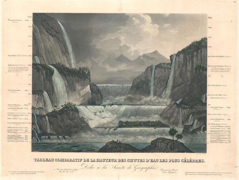
Tableau Comparatif de la Hauteur des Chutes d'Eau Les Plus Célèbres.
1835 (undated) 17.75 x 23.5 in (45.085 x 59.69 cm)
1835 (undated) 17.75 x 23.5 in (45.085 x 59.69 cm)
Description
A striking c. 1835 comparative chart illustrating the world's most famous waterfalls. The chart, in the 'Tableau Comparatif' model, sets the world's greatest waterfalls, as understood in the early 19th century, in sharp contrast with one another. When this chart was issued, the great waterfalls of the African Rift Valley and South America had yet to be discovered by Europeans. Thus, the tallest waterfall in the world is here presented as the Cascade de Gavarnie (422m), located in the Hautes-Pyrénées, France. Other waterfalls noted include the falls of the Missouri (186m), Niagara Falls (51m), and Switzerland's Staubbach Falls (297m). The artist, Himely, here attempts to represent the falls somewhat as they look in life, although has them all flowing into a single theoretical basin.
Publication History and Census
This map was compiled by the French mountaineer and geologist Louis Bruguière and drawn by the Swiss painter Sigismond Himely. It was published c. 1835 by the firm of Andriveau-Goujon for in editions of their popular Atlas Classique et Universel..CartographerS
Louis Bruguière (fl. c. 1820 - 1835) was a French mountaineer and geologist active in Europe in the first half of the 19th century. Bruguière is best known for his geological classification tables for the Alps which he laid out in his famous book, Orographie de l'Europe. He was a friend and correspondent of Alexander von Humboldt. In the 1830s he produced a series of 'Tableau Comparatif' charts for the publisher Andriveau-Goujon. More by this mapmaker...
Sigismond Himely (June 7, 1801 - 1872) was a Swiss painter, viewmaker, acquaint engraver active in Paris during the middle part of the 19th century. Hinley was born in La Neuveville, Bern, Switzerland, but moved to Paris to study painting with Copley Fielding (1787 - 1855) and Jean-Victor Bertin (1775 - 1842). He exhibited in the Paris Salons between 1824 and 1869. He is known for his work engraving aquatints for English watercolorists and his names is associated with numerous historical views, city bird's-eye panoramas, architectural illustrations, and ethnographic images, among them rare illustrations of Asia, Africa, and the Americas. Learn More...
Eugène Andriveau-Goujon (1832 - 1897) was a map publisher and cartographer active in 19th century Paris. The firm was created in 1825 when Eugène Andriveau married the daughter of map publisher Jean Goujon - thus creating Andriveau-Goujon. Maps by Andriveau-Goujon are often confusing to identify as they can be alternately singed J. Goujon, J. Andriveau, J. Andriveau-Goujon, E. Andriveau-Goujon, or simply Andriveau-Goujon. This refers to the multiple generations of the Andriveau-Goujon dynasty and the tendency to republish older material without updating the imprint. The earliest maps to have the Andriveau-Goujon imprint were released by Jean Andriveau-Goujon. He passed the business to his son Gilbert-Gabriel Andriveau-Goujon, who in 1858 passed to his son, Eugène Andriveau-Goujon, under whose management the firm was most prolific. Andriveau-Goujon published numerous fine pocket maps and atlases throughout the 19th century and often worked with other prominent French cartographers of the time such as Brue and Levasseur. The firm's stock was acquired by M. Barrère in 1892. Learn More...
Source
Classic and Universal Atlas of Ancient and Modern Geography, (Paris: Andriveau-Goujon) 1835.
Condition
Very good. Even overall toning. Light foxing and centerfold wear.