This item has been sold, but you can get on the Waitlist to be notified if another example becomes available, or purchase a digital scan.
1753 Bellin Map of the Empire of Japan
Japan-bellin-1753$400.00

Title
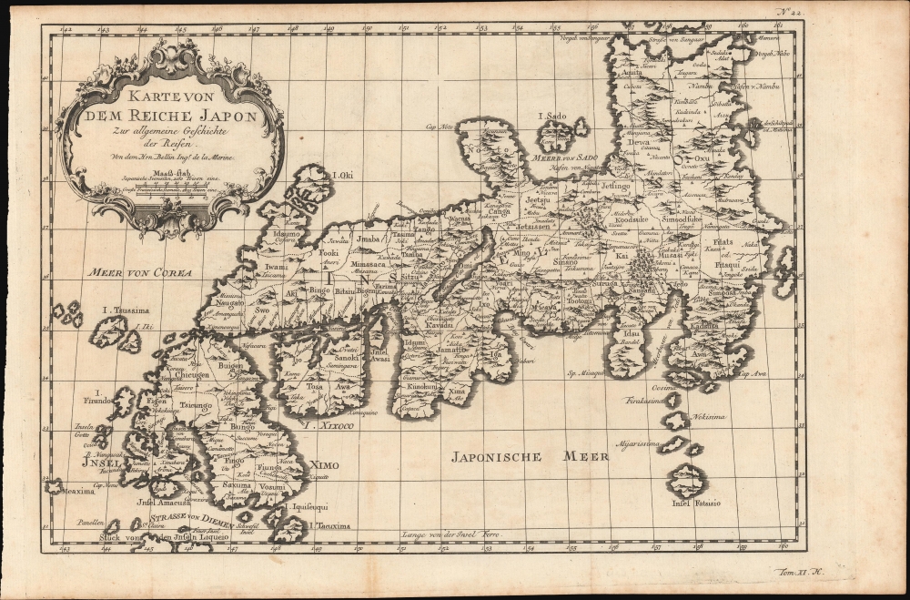
Karte Von Dem Reiche Japon.
1753 (undated) 9 x 13 in (22.86 x 33.02 cm) 1 : 5433000
1753 (undated) 9 x 13 in (22.86 x 33.02 cm) 1 : 5433000
Description
This is a beautiful 1753 Bellin map of the empire of Japan - here in the first German edition.
The map overall is highly inaccurate. Shikoku Island (here identified as I. Xixoco) appears to be almost square with a deep inlet on its northern side, while Kyushu (Insel Ximo) is slanted to the east. On the island of Honshu (Insel Nippon), the Aomori Prefecture is foreshortened while the Oki Islands appear exaggerated. The Shimane prefecture and the Noto Peninsula are also distorted. A rococo title cartouche is included in the upper left.
A Closer Look
Centered on the Bay of Osaka, this map covers from Hirado (here identified as I. Firando) and Nagasaki to Akita (Aquita), to include most of Tokugawa (Edo) era Japan. Hokkaido is not included. Towns, harbors, bays, provinces, mountains and daimyo are noted, although many are speculative.The map overall is highly inaccurate. Shikoku Island (here identified as I. Xixoco) appears to be almost square with a deep inlet on its northern side, while Kyushu (Insel Ximo) is slanted to the east. On the island of Honshu (Insel Nippon), the Aomori Prefecture is foreshortened while the Oki Islands appear exaggerated. The Shimane prefecture and the Noto Peninsula are also distorted. A rococo title cartouche is included in the upper left.
Sea of Korea / Sea of Japan
The sea between Japan and Korea, whose name, either the 'Sea of Korea', 'East Sea', or the 'Sea of Japan,' is here identified in favor of Korea (Meer von Corea). Maps published before the Japanese annexed Korea make references to the 'East Sea' or 'Sea of Korea'. Over time, neighboring and western countries have identified Korea's East Sea using various terms. The St. Petersburg Academy of Sciences referred to the east Sea as 'Koreiskoe Mope' or 'Sea of Korea' in their 1745 map of Asia. Other 17th and 18th century Russian maps alternate between 'Sea of Korea' and 'Eastern Ocean'. The 18th century Russian and French explorers Adam Johan von Krusenstern and La Perouse called it the 'Sea of Japan', a term that became popular worldwide. Nonetheless, the last official map published by the Russians names the East Sea the 'Sea of Korea'. The name is currently still a matter of historical and political dispute between the countries.Publication History and Census
This map first appeared in the 1752 French edition of A. F. Prevost's Histoire Generale des Voyages. Generally, the German editions are printed on stronger paper and have a sharper imprint. The present example was re-engraved for the 1753 first German edition of that work, Allgemeine Historie der Reisen zu Wasser und zu Lande.Cartographer
Jacques-Nicolas Bellin (1703 - March 21, 1772) was one of the most important cartographers of the 18th century. With a career spanning some 50 years, Bellin is best understood as geographe de cabinet and transitional mapmaker spanning the gap between 18th and early-19th century cartographic styles. His long career as Hydrographer and Ingénieur Hydrographe at the French Dépôt des cartes et plans de la Marine resulted in hundreds of high quality nautical charts of practically everywhere in the world. A true child of the Enlightenment Era, Bellin's work focuses on function and accuracy tending in the process to be less decorative than the earlier 17th and 18th century cartographic work. Unlike many of his contemporaries, Bellin was always careful to cite his references and his scholarly corpus consists of over 1400 articles on geography prepared for Diderot's Encyclopedie. Bellin, despite his extraordinary success, may not have enjoyed his work, which is described as "long, unpleasant, and hard." In addition to numerous maps and charts published during his lifetime, many of Bellin's maps were updated (or not) and published posthumously. He was succeeded as Ingénieur Hydrographe by his student, also a prolific and influential cartographer, Rigobert Bonne. More by this mapmaker...
Source
Prévost, A., Allgemeine Historie der Reisen zur Wasser und zu Lande: oder Sammlung aller Reisebeschreibungen.. in Englischen zusammen getragen, und aus demselben und dem Französischen ins Deutsche übersetzt,, tr. by Johann Joachim Schwabe, (Leipzig: Arkstee und Merkus) c. 1760.
Prévost's Histoire Générale des Voyages is a 15-volume compendium of travel literature initiated by Antoine François Prévost (Provost; 1697 - 1763) in 1746, intended as a universal history of exploration and geography. The initial publication, compiled from 1746 to 1759, spans 15 volumes and draws from a vast array of sources - travelers, explorers, missionaries, merchants, and diplomats - to present detailed narratives of significant global journeys. The work was initially published in Paris by Didot and offers ethnographic, political, religious, and natural observations about the peoples, cultures, flora, fauna, and geography. It is an ambitious attempt to organize knowledge about the world's diversity according to Enlightenment values, reflecting both scientific curiosity and imperial ideology. It functioned as both an informative reference and a literary work, influencing how European audiences understood and imagined distant lands. It proved extremely successful, and both reissues other publishers and pirate editions emerged, most notably Pierre de Hondt's 1747 Dutch edition and Jean-Franćois de la Harpe's 1780 abridged version. In addition to reissues of the original work, between 1768 and 1801, additional expanded volumes emerged, adding new voyages and histories. We have seen some sets with as many as 80 volumes. Over time, the Histoire générale des voyages became one of the most comprehensive and widely read travel collections of the 18th century, notable for blending factual reporting with the period's characteristic intellectual ambition.
Condition
Very good.
References
Walter, L., Japan a Cartographic Vision, p. 223.