This item has been sold, but you can get on the Waitlist to be notified if another example becomes available, or purchase a digital scan.
1943 Wisner Map of the Japanese Empire During WWII for the <i>Chicago Sunday Tribune</i>
JapansMilitaryExpansion-wisner-1943$112.50


Title
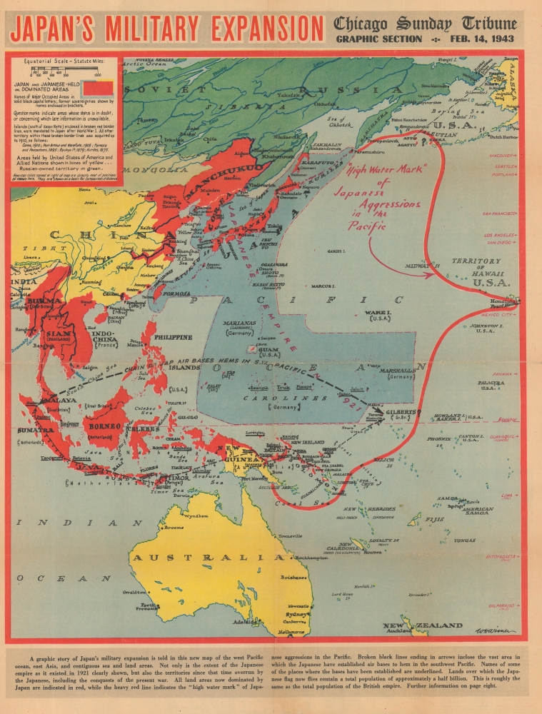
Japan's Military Expansion.
1943 (dated) 19 x 14.5 in (48.26 x 36.83 cm) 1 : 31680000
1943 (dated) 19 x 14.5 in (48.26 x 36.83 cm) 1 : 31680000
Description
This is a 1943 William Wisner map of the Japanese Empire during World War II. Published on February 14, 1943, Wisner's map captures the moment when the tide of the war was turning in the Allies' favor. The American Navy sank 4 Japanese aircraft carriers during the June 1942 Battle of Midway, and the Japanese had been on the back foot since. The Battle of Guadalcanal ended just days before this map's publication, securing the first Allied ground victory in the Pacific. By publishing this map, the Chicago Sunday Tribune gave its readers a visual summary of the status of the war in the Pacific following the critical victory at Guadalcanal.
A Closer Look
Depicting the western Pacific and East Asia, a dashed-and-dotted line encloses the Japanese Empire from Karafuto south to the Caroline Islands and the Marshall Islands. Japan and its overrun territories are highlighted in red, including Southeast Asia, the Philippines, Indonesia, and parts of China. Half of New Guinea and Guadalcanal are yellow after the Allies successfully captured Guadalcanal and invaded New Guinea. The bold red line marks the 'high water mark' of Japanese aggression in the Pacific, but it doesn't quite reach Pearl Harbor, which appears along the right. The black dashed line encircles the area where the Japanese have established air bases that could reach Australia and other Allied positions.Publication History and Census
This map was drawn by William Wisner and published by the Chicago Sunday Times on February 14, 1943. We note a single cataloged example in OCLC, at the University of Chicago.Cartographer
William H. Wisner (1894 - December 11, 1963) was the manager of the editorial art department of The Chicago Tribune. Born in Brooklyn, Wisner attended Columbia University and the College of the City of New York. He then attended the Julian academy in Paris where he received his formal art training. He began working for the Tribune in 1913, but left the newspaper during World War I to serve as an attache to the inter-allied mission for propaganda. He rejoined the Tribune in 1919 as head of its editorial art department. Wisner held several posts over the course of his career with the Tribune, including several influential and revolutionary positions concerning the integration of photography into the newspaper. His greatest work, though, was 'when he devoted himself entirely to the complicated task of preparing full-color maps which provided Tribune readers with up-to-the-minute developments on the global battlefronts.' In 1948, Wisner resumed full management of the editorial art department and held that position until his retirement in January 1963. More by this mapmaker...
Condition
Good. Newsprint. Light wear along original fold lines. Closed edge tears professionally repaired on verso. Repair on recto in margin not effecting printed image. Close left margin.
References
OCLC 921254277.