This item has been sold, but you can get on the Waitlist to be notified if another example becomes available, or purchase a digital scan.
1660 Hollar View of Jerusalem at the time of the First Temple
Jerusalem-hollar-1660$4,250.00


Title
Ierusalem. Hierusalem Veteris Imago Vera.
1660 (dated) 16.25 x 43.5 in (41.275 x 110.49 cm)
1660 (dated) 16.25 x 43.5 in (41.275 x 110.49 cm)
Description
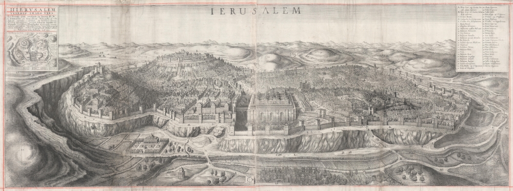
A spectacularly engraved large-scale 1660 Wenceslaus Hollar bird's-eye of Jerusalem during the period of the Solomon's Temple. The view is based upon the 1604 writings and drawings of Juan Bautista Villalpando (Villalpandus; 1552 - 1608), a Spanish Jesuit of Sephardic ancestry. The work, although mostly imaginary, proved highly influential.
A Closer Look
The view looks westward on the walled city of Jerusalem from the heights of Gethsemene, with the Valley of Josaphat in the foreground. Temple Mount, with the colonnaded Temple of Solomon on an enormous masonry base, bearing a decidedly European flair, occupies center field, with Solomon's Palace just to the south (left). The background is dominated by the Mountain Zion, with the City of David and David's Palace identified. A key in the upper right notes 55 landmarks, buildings, and monuments. Much of the ancillary architectures more closely resembles 17th century European cities, although with more domes, than anything then extent in Jerusalem. The Tomb of Absalom, however, in the lower left, is remarkably true to form. The whole is surrounded by red-ruled borders, as is common to most examples.Villalpando's Jerusalem
Villalpando's Jerusalem was a combination of fact and fantasy. It is particularly noteworthy for his imaginative recreation of Solomon's Temple. He believed that the Temple could be conceptually reconstructed based upon the laws of geometry, which he argued were laid down directly by God, via the prophet Ezekiel, and so unchanging and inviolate. Curiously, Villalpando's designs for the Temple, and may other buildings in Jerusalem, closely resemble Spanish architecture of his period, particularly the work of his mentor Juan de Herrera, whose designed incorporated quadratic inner courtyards and risalits - as here. Although Villalpando's Biblical interpretations earned him the ire of the Inquisition, it proved highly influential in the construction of multiple monasteries and other religious buildings, as well as theoretical depictions of Jerusalem (and Solomons Temple) as here, the construction of some European synagogues, and even 19th century Masonic literature.Publication History and Census
The source publication is unclear, and the piece may have been issued separately. In his Descriptive Catalogue of the Etched Work of Wenceslaus Hollar (Cambridge, 1982), Richard Pennington states the view was originally included in John Field's 1660 Restoration Bible (Cambridge). It does not however, appear in any known example of this publication. It is rare, we note an example appeared at Christies in 2017, where it sold for about 11000 USD. We were able to trace 2 further examples in private hands. OCLC records 2 institutional holdings. A further holding is known at the Metropolitan Museum of Art.Cartographer
Wenceslaus Hollar (July 23, 1607 - March 25, 1677) was a Czech / Bohemian artist, etcher and engraver, much of whose life was spent in England. He is known primarily for his engravings and etchings, of which nearly 2800 plates are known. These include a number of excellent maps and city views. He was born in Prague where he initially studied law. The 1620 Sack of Prague during the Thirty Years' War (1618 - 1648) ruined his family's fortunes. Hollar came out of the disruption on the path to becoming an artist. His earliest known works are small engravings, one of which was a copy of a Dürer 'Virgin and Child' and the other is very likely a 1625 outline map of Europe. By 1627 he was in Frankfurt, apprenticed to engraver Matthias Merian (1593 - 1650). Following his apprenticeship, he traveled throughout the Rhineland producing views of towns, castles, and landscapes. His work eventually attracted the notice and patronage of nobleman and art collector Thomas Howard, 21st Earl of Arundel (1585 - 1646). Hollar traveled with Howard from 1636 as a draftsman for the Earl's diplomatic mission to the court of Holy Roman Emperor Ferdinand II (1578 - 1637), as well as to Vienna and Prague. He also accompanied Arundel to England in 1637, where he remained for many years attached to the earl's household. He was not exclusively in the Earl's employ, producing work for many authors and publishers. He produced some very famous views of London following the Great Fire, and was sent in 1668 by the King to Tangier in order to produce views of the towns and forts there. He produced a number of maps for Richard Blome's subscription atlas, the first English atlas actually engraved in England. Unfortunately, his ties with the loyalists during the English Civil War (1642 - 1651) sharply affected his sales, and his patronage declined. He appears not to have been a particularly apt businessman: a friend is recorded as having said of him that he was, 'a very friendly good-natured man as could be, but shiftlesse to the world.' It cannot have helped matters that he only charged a shilling an hour for his labors. Despite the quality of his work, he would die in poverty. More by this mapmaker...
Condition
Good. Some edge wear and margin repairs. Area of expert reinstatement just west of the Tomb of Absalom (Mons Absolon). Wear and soling along some of the original fold lines. Two sheets, joined at center by publisher. Manuscript red ruling.
References
OCLC 974373830.