1645 Visscher Map of Biblical Jerusalem
Jerusalem-visscher-1645$950.00

Title
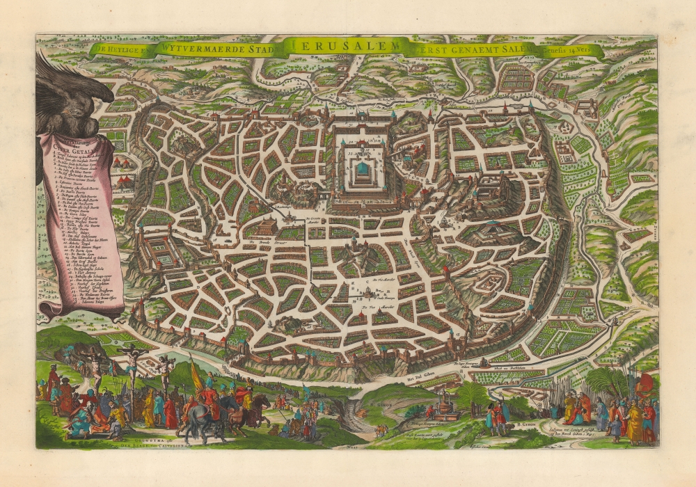
De heylige en wytvermaerde stadt Ierusalem eerst genaemt Salem: Genesis 14, vers 18.
1645 (undated) 12.5 x 18.75 in (31.75 x 47.625 cm) 1 : 5000
1645 (undated) 12.5 x 18.75 in (31.75 x 47.625 cm) 1 : 5000
Description
This is Claes Janszoon Visscher's scarce 1645 view/map of Biblical Jerusalem, depicting the Temple of Solomon, Herod's Palace, and the city's streets and markets as derived from scriptural sources. Vignettes include Solomon's anointment in the lower right, and the Crucifixion on the lower left. The plan's title is displayed across the top. To the left, a banner held unfurled by an eagle offers a legend of thirty-six numbered features.
Visscher's source is the unacquirable 1630 plan printed by Lünenburg theological publishers Johann and Heinrich Stern. The present work is larger than the Sterm map, and is of a much higher caliber of engraving artistry. While there are certainly earlier depictions of the Holy City based on scriptural sources, most such were based on the fanciful 1584 Christian van Adrichom map. The Stern brothers perspective is both accurate and sophisticated.
Visscher's source is the unacquirable 1630 plan printed by Lünenburg theological publishers Johann and Heinrich Stern. The present work is larger than the Sterm map, and is of a much higher caliber of engraving artistry. While there are certainly earlier depictions of the Holy City based on scriptural sources, most such were based on the fanciful 1584 Christian van Adrichom map. The Stern brothers perspective is both accurate and sophisticated.
Publication History and Census
This map was engraved by C. J. Visscher, as early as 1645. It was number four in a series of six maps engraved for inclusion in Dutch Bibles as late as the 1660s. Laor dates other maps in this series more emphatically as 1645, and so we will follow that dating here. The text at the bottom to the right of center 'Dese Kaerte wert gestalt voor het 3 Cap. Nehemia' indicates the intention that it be inserted in a Bible before Nehemiah, chapter 3. This map is very frequently miscatalogued both as Visscher's dated 1643 map of the same title (whose legend appears in a text box at lower left instead of the Crucifixion scene) and inexplicably also as the 1648 Jaco Savry map, copied from the 1643 Visscher. We see only two separate examples listed (incontrovertibly) in OCLC at the University of Florida and the Universiteit van Amsterdam.CartographerS
Claes Jansz Visscher (1587 - 1652) established the Visscher family publishing firm, which were prominent Dutch map publishers for nearly a century. The Visscher cartographic story beings with Claes Jansz Visscher who established the firm in Amsterdam near the offices of Pieter van den Keer and Jadocus Hondius. Many hypothesize that Visscher may have been one of Hondius's pupils and, under examination, this seems logical. The first Visscher maps appear around 1620 and include numerous individual maps as well as an atlas compiled of maps by various cartographers including Visscher himself. Upon the death of Claes, the firm fell into the hands of his son Nicholas Visscher I (1618 - 1679), who in 1677 received a privilege to publish from the States of Holland and West Friesland. The firm would in turn be passed on to his son, Nicholas Visscher II (1649 - 1702). Visscher II applied for his own privilege, receiving it in 1682. Most of the maps bearing the Visscher imprint were produced by these two men. Many Visscher maps also bear the imprint Piscator (a Latinized version of Visscher) and often feature the image of an elderly fisherman - an allusion to the family name. Upon the death of Nicholas Visscher II, the business was carried on by the widowed Elizabeth Verseyl Visscher (16?? - 1726). After her death, the firm and all of its plates was liquidated to Peter Schenk. More by this mapmaker...
Johann von Stern (1582-1656) and Heinrich Stern (1592-1665) were publishers in Lünenburg, Germany. They were prolific, with a focus primarily on religious matter: theological works, hymnals and Bibles. They produced an emngraved plan of the Biblical Jerusalem in 1630 which would be copied by various mapmakers, notably Visscher. The Sterns' version appears to be extremely rare. Learn More...
Condition
Excellent. Bottom margin expertly extended, beginning nearly an inch outside printed area. Margins complete with a sharp strike and fine hand color.
References
OCLC 945554660. Laor, E., Maps of the Holy Land, #1155.