This item has been sold, but you can get on the Waitlist to be notified if another example becomes available.
1955 Steimatsky Pictorial Map of Jerusalem in Hebrew
JerusalemHebrew-steimatsky-1955-2$275.00

Title
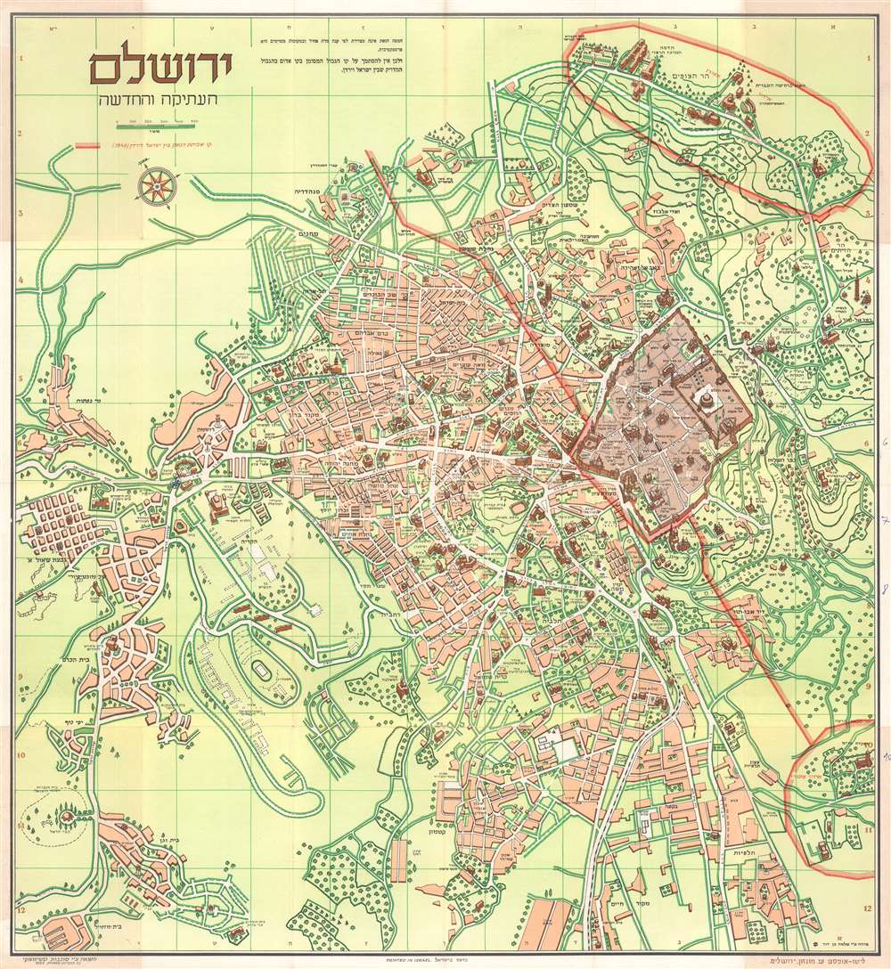
ירושלם העתיקה והחדשה. / Jerusalem Old and New.
1955 (dated) 26.5 x 24.5 in (67.31 x 62.23 cm) 1 : 9250
1955 (dated) 26.5 x 24.5 in (67.31 x 62.23 cm) 1 : 9250
Description
This is a 1955 Steimatzky pictorial map of Jerusalem in Hebrew. The map depicts the city from the Beth Hakerem neighborhood to the Mount of Olives and the 'Hill of Evil Counsel' and from Mt. Scopus to Meqor Hayim and Beth Mazmil. Perhaps most significantly, it dates from 1955, when the 1949 Armistice Agreement between Israel and Jordan was still in effect (the borders remained unchanged until after the 1967 Six-Day War), illustrated here by a rather thick red line.
Later, however, during the meetings in Rhodes to hammer out the 1949 Armistice Agreements, the map between these two commanders was found to be the only official document indicating the line dividing Jerusalem that was agreed upon by both parties. Thus, the informality and the inaccuracies went from being a ceasefire agreement between two commanders on the ground to a binding international border. This meant that neighborhoods, streets, and even houses became points of contentious international dispute, as the line drawn on this map was rough at best. The border quickly became fortified, with military positions springing up all along the border and landmines were deployed in the No Man's Land. Included in this agreement was an Israeli-controlled area on Mt. Scopus, which is encircled here by the same red line that bisects the city. A bi-weekly convoy to the Israeli enclave on Mt. Scopus crossed the border between the two states through the Mandelbaum Gate, which is labeled here.
Jerusalem's Pre-1967 Borders, also known as 'The Green Line
The 'Green Line' agreement was never meant to signify permanent international borders, only a temporary demarcation between Israel and Jordan following the 1948 Arab-Israeli War. The 'Green Line' even extended through Jerusalem, dividing the city into East Jerusalem, which was part of the Kingdom of Jordan, and West Jerusalem, the capital of the newly-created State of Israel. When the ceasefire was finally declared, an Israeli and Jordanian commander met in an abandoned house to outline the boundaries of the ceasefire. The Israeli commander used a green wax pencil to outline Israeli-controlled positions, while the Jordanian commander used a red pencil to outline positions under Jordanian control, with the area between the two lines becoming a No Man's Land. Neither commander believed that this informally arrived at agreement represented anything more than a temporary ceasefire line, meaning that little notice was given to inaccuracies and errors included in their work due to the thickness of the pencils, deviations in the drawings, or segments of discontinuous lines.Later, however, during the meetings in Rhodes to hammer out the 1949 Armistice Agreements, the map between these two commanders was found to be the only official document indicating the line dividing Jerusalem that was agreed upon by both parties. Thus, the informality and the inaccuracies went from being a ceasefire agreement between two commanders on the ground to a binding international border. This meant that neighborhoods, streets, and even houses became points of contentious international dispute, as the line drawn on this map was rough at best. The border quickly became fortified, with military positions springing up all along the border and landmines were deployed in the No Man's Land. Included in this agreement was an Israeli-controlled area on Mt. Scopus, which is encircled here by the same red line that bisects the city. A bi-weekly convoy to the Israeli enclave on Mt. Scopus crossed the border between the two states through the Mandelbaum Gate, which is labeled here.
A Closer Look at the Map
A charming and highly detailed map, locations throughout the city are labeled. Major streets cross the city and roads to other towns, such as Bethlehem and Ramallah, are noted. Numerous buildings are illustrated in profile and labeled, including the walls and gates of the Old City, the Dome of the Rock, and the Wailing Wall. Important religious sites are also labeled, such as the Tomb of the Virgin and the Tomb of Zacharias, intermixed with modern sites, including the National Library, a police training school, a public pool, and a Barclays bank branch. Two sites are ghosted into the Israeli portion of the city: one illustrates the Tenth Roman Legion camp, while the other traces the projected site for Hebrew University buildings.Publication History and Census
This map was drawn by Shlomo Ben David and published by Steimatzky in 1955. This map is well represented in institutional collections and is part of the collections at the New York Public Library, the Massachusetts Institute of Technology, Duke University, Arizona State University, and the National Library of Israel.Cartographer
Steimatzky (1920 – present) is the oldest and largest bookstore chain in Israel. Founded by Tzvi Steimatzky in 1920, the first store was opened in Tel Aviv at 6 Hertzel Street. Steimatzky's half-brother Yechezkel Steimatzky opened the second store on Jaffa Road in Jerusalem in 1925. Yechezkel, a Russian-born immigrant from Germany, originally went to the British Mandate of Palestine for the opening of the Hebrew University of Jerusalem, but decided to stay after he saw the potential for success in opening a foreign language bookstore whose clients would be a growing population of immigrants along with British Army soldiers serving under the British Mandate. He found that the bookstore was so successful that he opened another store in Haifa the following year. By 1927, the Steimatzky brand had expanded outside the British Mandate, when a store opened in Beirut. During World War II, a Steimatzky store opened in Baghdad next to the British Army base, and branches in Cairo, Alexandria, and Damascus soon followed. After the outbreak of the 1948 Arab-Israeli War, the expansion throughout the Middle East came to an end. In 1948 another store opened in Tel Aviv on Allenby Street. Eri Steimatzky, Yechezkel's son, joined the company and became its general manager in 1963. By 2010, Steimatzky operated over 160 stores throughout Israel, dominating the market in Israel. By September 2017, however, the gap between Steimatzky and its closest competitor, Tzomet Sfarim, was closing; Steimatzky had reduced their number of branches to 140 compared to Tzomet Sfarim's 96 stores. More by this mapmaker...
Condition
Very good. Exhibits light wear along original fold lines. Exhibits some toning. Exhibits small areas of loss along a fold line and at a handful of fold intersections. Exhibits manuscript ink notations in right margin. All text in Hebrew. Text on verso.
References
OCLC 53991773.