1943 Army Orientation Course Newsmap of the Mediterranean Sea and North Africa
June21-newsmap-1943$300.00

Title
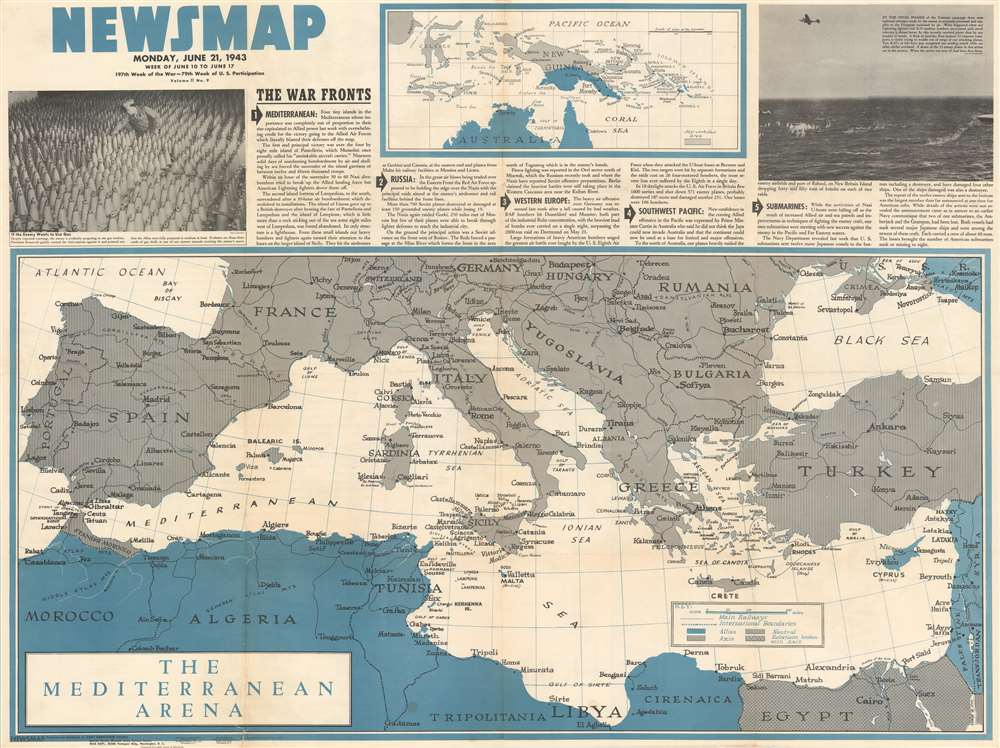
NEWSMAP Monday, June 21, 1943. Week of June 10 to June 17.
1943 (dated) 34.5 x 46.5 in (87.63 x 118.11 cm) 1 : 12672000
1943 (dated) 34.5 x 46.5 in (87.63 x 118.11 cm) 1 : 12672000
Description
This 1943 Army Orientation Course Newsmap map of the Mediterranean, Europe, and North Africa details Allied operations in the middle of June. Short paragraphs describe five significant events from the past week. The most important, particularly with the benefit of hindsight, garners top recognition: The Allied capture of four small islands in the Mediterranean. Published only a few weeks before the Allied invasion of Sicily, codenamed Operation Husky, the eviction of Italian forces from these islands removed one of the last hurdles to the forthcoming landings. From Sicily, the Allies would jump to mainland Italy, the first Western Allied assault on Axis-occupied Europe. Other actions recounted include brutal fighting on the Eastern Front between the Nazis and the Red Army, British and American aerial bombardments of targets in Germany, and an announcement that U.S. submarines sunk another dozen Japanese ships the previous week.
The Mediterranean and South Pacific Maps
A brilliant blue shades areas occupied by the Allies, including the four islands discussed above. Gray regions mark Axis occupied countries and Spain, Portugal, and Turkey are marked as neutral.Publication History and Census
This map was created and distributed by the Army Orientation Course in 1943. Seven examples are cataloged in OCLC and are part of the institutional collections at the Boston Athenaeum, Pennsylvania State University, Denison University, Davidson College, the Library of Michigan, Southern Illinois University at Edwardsville, and the Denver Public Library.Cartographer
The Army Orientation Branch (1940 - c. 1949) created special maps for teaching the Army Orientation Course and was based at The Pentagon in Washington, D.C. The Army Orientation Branch was part of the Information and Education Division. More by this mapmaker...
Source
NEWSMAP Series.
Newsmaps were published weekly between April 1942 and March 1946. Their content usually featured world maps, short summaries of the week’s military action, and photographs of troops and materiel. Early Newsmaps were printed on one side only, but, later in the war, they were printed on both sides, with the reverse bearing large-format maps, photographs, or other visual information. Several different versions of Newsmaps were produced: a large domestic version, a smaller overseas version, and an industrial version, which included more information about war production efforts. Two other editions appear in the United States Government Publications Monthly Catalogs, a 'Newsmap Special Edition' and a 'Newsmap Special Supplement for Special Training Units'.
Per the National Archives and Records Administration, ‘NEWSMAPS were not issued for general distribution. The posters were distributed to military installations, government and civilian groups working on War Department projects, and certain depository libraries, as designate by Congress, and one copy to Congressmen, if requested.’ The importance of the Newsmaps to the Army is related in the 1944 Basic Field Manual for The Special Service Company. The Manual states that as soon as the company reaches its destination ‘the company commander should contact the Special Service Branch in theater of operations headquarters, for copies of the weekly Newsmap.’ Also per the Manual
Per the National Archives and Records Administration, ‘NEWSMAPS were not issued for general distribution. The posters were distributed to military installations, government and civilian groups working on War Department projects, and certain depository libraries, as designate by Congress, and one copy to Congressmen, if requested.’ The importance of the Newsmaps to the Army is related in the 1944 Basic Field Manual for The Special Service Company. The Manual states that as soon as the company reaches its destination ‘the company commander should contact the Special Service Branch in theater of operations headquarters, for copies of the weekly Newsmap.’ Also per the Manual
The librarian should check the weekly Newsmap as soon as it is made available and should post it in a conspicuous place. He should take steps to see that the place where the Newsmap is posted is made known to all troops of the area in which the company or platoon is operating. This can be done effectively through notices in soldier newspapers, verbal announcements by those directly in charge of troops, and by posting announcements on bulletin boards.
Condition
Very good. Exhibits wear and soiling along original fold lines. Verso repair to fold separation. 'Disease in the Tropics' illustrations and information printed on verso.
References
OCLC 60847355.