1920 Gallup Map Company Map of Kansas City, Missouri
KansasCity-gallup-1920$375.00


Title
Official guide and map for greater Kansas City...
1920 (undated) 22.5 x 13 in (57.15 x 33.02 cm) 1 : 30500
1920 (undated) 22.5 x 13 in (57.15 x 33.02 cm) 1 : 30500
Description
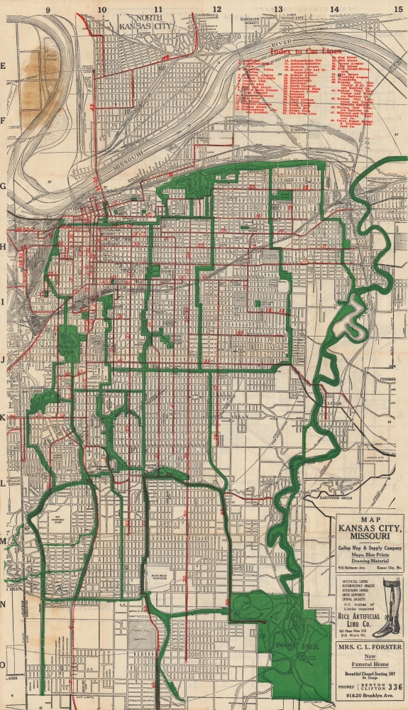
A c. 1920 folding map of Kansas City, Missouri published by the Gallup Map and Supply Company. It shows the city near its population peak, when a series of impressive infrastructure and public works projects reshaped the city.
At left near top are the Kansas City Stockyards, which boomed during the second half of the 19th century and by 1871 were the second largest stockyards in the United States, only behind Chicago. However, the Great Flood of 1951 destroyed the Kansas City Stockyards and they never fully recovered.
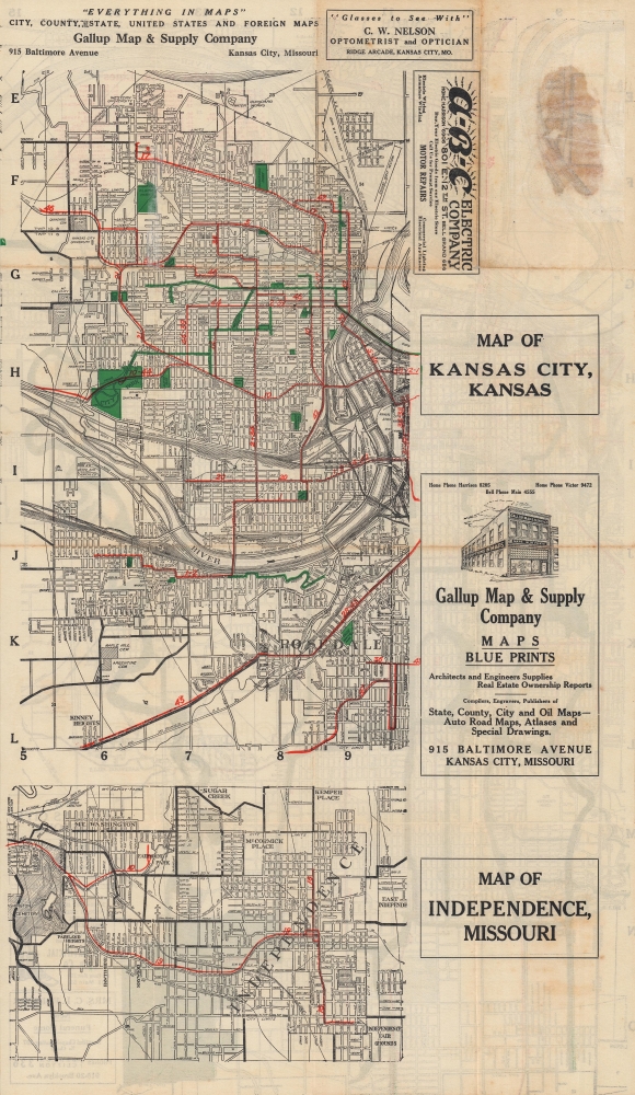
The verso includes two maps: at top, is a continuation of the map on the recto, extending further west to the suburbs on the Kansas side of the border. At bottom is a map of Independence, Missouri, a suburb but also a city in its own right. Both sides include advertisements, including a depiction of Gallup's own building at 915 Baltimore Ave.
This map was produced in the 'Pendergast era' when the Democratic political machine run by bosses (and brothers) Tom and James Pendergast controlled the city. Among the results of this system was the effective lack of enforcement of federal Prohibition laws, carrying on the tradition of Kansas City serving as a refuge from Kansas's statewide prohibition laws dating to the 1880s. Though marred by corruption (the Pendergasts owned a concrete company that reliably received city contracts) and even violence, the era also saw the revamping and beautification of the city's major boulevards and public spaces, resulting in the extensive system of parks and parkways seen here.
A Closer Look
The most striking feature of this map is the bold red and green colors used to mark out the city's streetcar lines (48 of them, indexed at top) and greenspaces, respectively. These serve as a reminder of the conception of urban planning in the era before automobiles became dominant. An alphanumeric grid in the margins provides an easy method for locating sites and neighborhoods throughout the city. Concentric circles emanate from Union Station at the city's historic center at left.At left near top are the Kansas City Stockyards, which boomed during the second half of the 19th century and by 1871 were the second largest stockyards in the United States, only behind Chicago. However, the Great Flood of 1951 destroyed the Kansas City Stockyards and they never fully recovered.
The verso includes two maps: at top, is a continuation of the map on the recto, extending further west to the suburbs on the Kansas side of the border. At bottom is a map of Independence, Missouri, a suburb but also a city in its own right. Both sides include advertisements, including a depiction of Gallup's own building at 915 Baltimore Ave.
This map was produced in the 'Pendergast era' when the Democratic political machine run by bosses (and brothers) Tom and James Pendergast controlled the city. Among the results of this system was the effective lack of enforcement of federal Prohibition laws, carrying on the tradition of Kansas City serving as a refuge from Kansas's statewide prohibition laws dating to the 1880s. Though marred by corruption (the Pendergasts owned a concrete company that reliably received city contracts) and even violence, the era also saw the revamping and beautification of the city's major boulevards and public spaces, resulting in the extensive system of parks and parkways seen here.
Publication History and Census
This map was published by the Gallup Map and Supply Company around or before 1920. The prevalence of streetcar lines and the style of text or advertisements would likely preclude a later date. The map also lacks the Liberty Memorial, now the National World War I Museum and Memorial, built in Penn Valley Park, which broke ground in 1921 and opened in 1926. Maps with this title or similar titles were published by Gallup from the 1910s - 1950s, but we are unable to locate any other examples of the present map in institutional collections or on the market.Cartographer
Gallup Map and Supply Company (1875 - present) is an American map company founded in Kansas City, Missouri in 1875. Originally, the Gallup Map Company created local street atlases and wall maps and, with the advent of cell phones and GPS, have transitioned into creating reproductions of historical and vintage maps. More by this mapmaker...
Condition
Very good. Light wear along original fold lines. Two small areas of loss at fold intersections. Verso repair to a fold separation. Soiling where previously attached to guidebook. Map of Kansas City, Kansas on verso.