This item has been sold, but you can get on the Waitlist to be notified if another example becomes available, or purchase a digital scan.
1838 Carless Map of Karachi City and Harbor - fist map of Karachi!
Karachi-carless-1838$2,750.00

Title
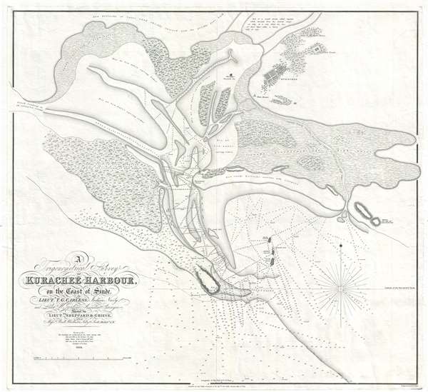
A Trigonometrical Survey of Kurachee Harbour, on the Coast of Sinde.
1844 (dated) 25.5 x 28 in (64.77 x 71.12 cm) 1 : 84500
1844 (dated) 25.5 x 28 in (64.77 x 71.12 cm) 1 : 84500
Description
This is the first map of Karachi city and harbor, modern day Pakistan, drawn from Thomas Greer Carless' exploratory surveys of 1838. Carless, along with fellow India Navy Officers W. Jardine, Sheppard, and Grieve, was sent to survey the coast of Sinde in the vicinity of Karachi in 1838. Their work produced this, the first mathematical survey of Karachi city and harbor, and set the stage of the British East Indian Company occupation of Karachi in February of 1839.
The old fort and city of 'Kurachee,' then, according to Carless, a diverse town of about 14000 appears in the upper right. The survey reveals a port almost inaccessible to large vessels, with a low water depth of only 1 or 2 feet close to the city. Nonetheless, with a tidal variation of about 15 feet, the city could be accessed at certain times of the day and the British East India Company, recognizing the need for an additional defensible port on the Indian Ocean, determined that Karachi was ideally suited. Following the occupation, they began an extensive series of improvements, roughly lasting to 1869, which opened the port fully to deep water shipping at all times. Today Karachi is a major Indian Ocean port and one of the world's largest cities, with a population of nearly 22 million.
The map notes a number of additional important sites, including the 17th century Talpur Dynasty Qasim Fort on Manora Point. The map also notes the ruins of an abandoned English factory just north of the city. Also northeast of the city is the 'Fakeers Tank' or Fakir's Tank, where early travelers to the region, including Leopold Von Orlich, writing in 1845, claimed that the fakirs kept some 30 alligators which were trained 'like so many dogs.'
Although this map was submitted to the government in 1838, following the completion of Carless' survey, it was not published until 1844 by John Walker in 1844. We have found no evidence of an earlier edition and in fact, no other original examples are known, but it is highly likely that at least one such is held in the archives of the British Library.
CartographerS
Thomas Greer Carless (1806 - December 16, 1848) was a British hydrographer and naval officer active in the Indian Navy. Carless distinguished himself in the First Anglo-Burmese War (1824-1826). Following the war, he was assigned to assist Robert Moresby in the important 1831 – 1833 survey of the Red Sea, for which he is today best known. Carless was next assigned to Captain Haines where he produced a hydrographic survey of the South Coast of Arabia. In 1837, he was transferred to Africa in the vicinity of Cape Guardafui (Ras Asir, Somalia) where he surveyed much of the coast. In 1838, Carless was sent to survey the Indus River, work for which he is less well known but which is perhaps his most historically significant. This included the first survey of Karachi Harbor, presaging the 1839 British East India Company occupation of subsequent development of that city as a major port. Carless' work with Moresby in the Red Sea was highly praised for by none other than Richard F. Burton, who wrote in First Footsteps in East Africa,
The beautiful maps of the Red Sea, drafted by the late Commodore Carless, then a lieutenant, will ever remain permanent monuments of Indian Naval Science, and the daring of its officers and men.He was subsequently variously employed throughout the region, including 1846 survey correction work in the Persian Gulf. There he attained the rank of Commodore and was given command of the Persian Gulf Squadron, but he unfortunately contacted Small Pox shortly after and died in the city of Bushehr (Iran). More by this mapmaker...
John Walker (1787 - April 19, 1873) was a British map seller, engraver, lithographer, hydrographer, geographer, draughtsman, and publisher active in London during the 19th century. Walker published both nautical charts and geographical maps. His nautical work is particularly distinguished as he was an official hydrographer for the British East India Company, a position, incidentally, also held by his father of the same name. Walker's maps, mostly published after 1827, were primarily produced with his brothers Charles Walker and Alexander Walker under the imprint J. and C. Walker. Among their joint projects are more than 200 maps for the influential Society for the Diffusion of Useful Knowledge Atlas (SDUK). In addition they published numerous charts for James Horsburgh and the British Admiralty Hydrographic Office, including Belcher's important map of Hong Kong and Carless' exploratory map of Karachi. The J. and C. Walker firm continued to publish after both Walkers died in the 1870s. Learn More...
Condition
Very good. Original plate mark visible.
References
OCLC 316443633 (facsimile, Library of Scotland)